Maps of Europe

Kompas omniumkaart bevattende: Noorwegen, Zweden, Finland, Europeesch Rusland, Europ. en Aziatisch Turkije, Irak, Middell. Zeegebied, en Suez
1 : 5500000 Den Haag : Kompas
Rußland
1 : 18000000 Russland / Europäischer Teil
Rußland
1 : 18000000 Russland / Europäischer Teil
Skandinavien und Rußland
1 : 18000000 Skandinavien, Osteuropa
Skandinavien und Rußland
1 : 18000000 Skandinavien, Osteuropa
Europaeisches Russland
E. von Sydow's Schul-Atlas in sechs und dreissig Karten Sydow, Emil von bei Justus Perthes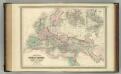
Roman Empire at the Time of Christ.
1 : 12300000 Johnson, A.J.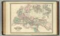
Roman Empire at the Time of Christ.
1 : 12300000 Johnson, A.J.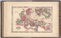
Roman Empire.
1 : 14630000 Johnson, A.J.
[Neuer Atlas der ganzen Erde nach den neuesten Bestimmungen ... : II.] Europa
Entworfen und gezeichnet von F.W. Streit H. Leutemann sc. Leipzig : J.C. Hinrichs'sche Buchhandlung
Russland
Volksschul-Atlas über alle Teile der Erde Lange, Henry Druck und Verlag von Georg Westermann
Carte générale orographique et hydrographique de l'Europe, qui montre les principales ramifications des montagnes, fleuves et chemins avec les principales villes
1 : 4600000 dressée d'aprés les meilleures cartes des auteurs les plus acredités par le Général Baron Sorriot de L'Host gravée par Joseph List. Vienne, [s.n.]
Europaeisches Russland mit Kasan, Astrachan und Georgien
Schul-Atlas über alle Theile der Erde nach dem neuesten Zustande, und über das Weltgebäude Stieler, Adolf Justus Perthes
Europa nach seinem politischen Zustande im Jahr 1828
Historisch-genealogisch-geographischer Atlas von Le Sage Las Cases, Emmanuel Auguste Dieudonné Marius Joseph de Johann Velten, Kunsthändler
Europa um 1740
1 : 15000000 Europa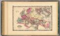
Roman Empire.
1 : 14572800 Johnson, A.J.
Europa
Schul-Atlas in 36 Karten Völter, Daniel Verlag der J.M. Dannheimer'schen Buchhandlung
Europa zur Uebersicht der Flussgebiete und Höhenzüge
Hand-Atlas über alle Theile der Erde nach dem neuesten Zustande und über das Weltgebäude Stieler, Adolf bei Justus Perthes
Carte générale des chemins de fer de la Russie
1 : 6000000 Napoléon Chaix
[Karte von Europa, Zur Übersicht der Wärme-Verbreitung in diesem Erdtheile]
Erster Band, enthaltend in vier Abtheilungen die Erscheinungen der anorganischen Natur: 1. Meteorologie und Klimatographie. 2. Hydrologie und Hydrographie. 3. Geologie. 4. Tellurischer Magnetismus Humboldt, Alexander von Verlag von Justus Perthes
Europe.
1 : 43000000 Bowen, Frances
Europa nach seinen ethnographischen Verhältnissen in der Mitte des XIX Jahrhunderts
1 : 15000000 Europa ethnische Gruppe
Europa Übersicht der politischen Verhältnisse und Hauptverkehrswege
1 : 20000000 Europa Verkehrsnetz
Machtverhältnisse der Europ. Staaten
1 : 14000000 Übersichtskarte Block, Maurice Justus Perthes
Europa
Atlas der Geologie Zittel, K.v. ; Berghaus, Hermann Justus Perthes
Europa, Staatenkarte
1 : 25000000 Europa
Hauptverbindungslinien von Europa als Mittelpunkt des Welverkehrs
Geographischer Atlas über alle Theile der Erde Ziegler, Jakob Melchior Verlag von Joh. Wurster um Comp.
Tabula Russiae [...] [Karte] Moscua ad Architypum Foedori Borißowitsi [Planvedute, Karte], in: Le théâtre du monde, ou, Nouvel atlas contenant les chartes et descriptions de tous les païs de la terre, Bd. 1, S. 67.
1 Karte aus Atlas Blaeu, Willem Janszoon und Blaeu, Joan Blaeu, Willem Janszoon
Imperium Romanorum latissime patens
Evropa Spruner, Karl von Justus Perthes


