Maps of Europe
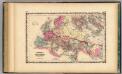
Roman Empire.
1 : 14572800 Johnson, A.J.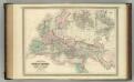
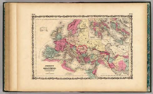
Roman Empire at the Time of Christ.
1 : 12300000 Johnson, A.J.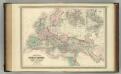
Roman Empire at the Time of Christ.
1 : 12300000 Johnson, A.J.
Carte générale orographique et hydrographique de l'Europe, qui montre les principales ramifications des montagnes, fleuves et chemins avec les principales villes
1 : 4600000 dressée d'aprés les meilleures cartes des auteurs les plus acredités par le Général Baron Sorriot de L'Host gravée par Joseph List. Vienne, [s.n.]
[Neuer Atlas der ganzen Erde nach den neuesten Bestimmungen ... : II.] Europa
Entworfen und gezeichnet von F.W. Streit H. Leutemann sc. Leipzig : J.C. Hinrichs'sche Buchhandlung
Kaart van Europa voor schoolgebruik bewerkt / door H. Blink
1 : 3000000 Annotatie: Met: Lengte en vermogen van eenige stroomen onderling vergeleken; Annotatie geografische gegevens: Schaalstok van 300 km; Legenda; 3 bijkaarten 1: Typisch voorbeeld van ligging en profil der fjorden in Noorwegen, 15,5 x 19,5 cm. 2: Simplonpas en St. Gothardspoorweg, schaal 3:500.000, 15,5 x 18,5 cm, resp. 24,5 x 9,5 cm. 3: Kaart van de Alpen, schaal 1:1.500.000, 34 x 49 cm Ten Brink, Meppel Meppel : H. ten Brink / (Groningen : J.H. van de Weijer)
Europa
Hypsometrischer Atlas Ziegler, Jakob Melchior Topogr. Anstalt v. J. Wurster u. Comp.
Europa
Handatlas über alle Theile der Erde und über das Weltgebäude Stieler, Adolf Justus Perthes
Europe.
1 : 43000000 Bowen, Frances
Hauptverbindungslinien von Europa als Mittelpunkt des Welverkehrs
Geographischer Atlas über alle Theile der Erde Ziegler, Jakob Melchior Verlag von Joh. Wurster um Comp.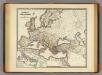
Imperium Romanorum inde a Constantini Magni tempore.
1 : 15500000 Menke, Th.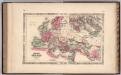
Roman Empire.
1 : 14630000 Johnson, A.J.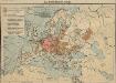
Das Deutschtum in Europa
1 : 36000000 Europa Ethnische Gruppe, Deutsche
Europa
Schul-Atlas in 36 Karten Völter, Daniel Verlag der J.M. Dannheimer'schen Buchhandlung
Imperium Romanorum latissime patens
Evropa Spruner, Karl von Justus Perthes
Imperium Romanorum post divisionem occidentale & orientale
Evropa Spruner, Karl von Justus Perthes
Europa
Neuer Handatlas über alle Theile der Erde Kiepert, Heinrich Verlag von Dietrich Reimer
Europa zur Zeit Napoleon's I. (um 1810)
1 : 15000000 Europa Napoleon I., Frankreich, Kaiser
Europa, Staatenkarte
1 : 25000000 Europa
[Karte von Europa, Zur Übersicht der Wärme-Verbreitung in diesem Erdtheile]
Erster Band, enthaltend in vier Abtheilungen die Erscheinungen der anorganischen Natur: 1. Meteorologie und Klimatographie. 2. Hydrologie und Hydrographie. 3. Geologie. 4. Tellurischer Magnetismus Humboldt, Alexander von Verlag von Justus Perthes
Europa nach seinen ethnographischen Verhältnissen in der Mitte des XIX Jahrhunderts
1 : 15000000 Europa ethnische Gruppe
Machtverhältnisse der Europ. Staaten
1 : 14000000 Übersichtskarte Block, Maurice Justus Perthes
Europa nach dem Wiener Congress 1815
1 : 15000000 Europa
Europa um die Mitte des Vierzehnten Jahrhunderts
1 : 15000000 Europa
Europa
Atlas der Geologie Zittel, K.v. ; Berghaus, Hermann Justus Perthes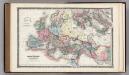
Roman Empire.
1 : 14495100 Fisher, Richard Swainson
Europa um 1740
1 : 15000000 Europa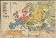
Völkerkarte von Europa
1 : 36000000 Europa Ethnische Gruppe
Europa ad magnae Europae Gerardi Mercatoris P. imitationem [...] [Karte], in: Gerardi Mercatoris Atlas, sive, Cosmographicae meditationes de fabrica mundi et fabricati figura, S. 61.
1 Karte aus Atlas Mercator, Gerhard Montanus, Petrus