Maps of Europe

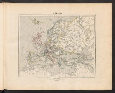
Europa
[Allgemeiner Atlas über alle Theile der Erde in 29 Blättern] Ziegler, Jakob Melchior Top. Anstalt v. J. Wurster u. Comp.
Florenkarte von Europa
Atlas der Pflanzenverbreitung Drude, Oscar Justus Perthes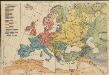
Völkerkarte von Europa
1 : 36000000 Europa Ethnische Gruppe
Handelskaart van Europa : ten dienste van het onderwijs / door J.J. ten Have
1 : 3333000 Annotatie: Met handelsprodukten en belangrijke handelsroutes J.J. ten Have 's-Gravenhage : Ykema
Hyetographic or Rain Map of Europe
The physical atlas Johnston, Alexander Keith William Blackwood & Sons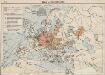
Das Deutschtum in Europa
1 : 36000000 Europa Ethnische Gruppe, Deutsche
Europa
Schul-Atlas in 36 Karten Völter, Daniel Verlag der J.M. Dannheimer'schen Buchhandlung
Europa
Geographischer Atlas über alle Theile der Erde Ziegler, Jakob Melchior Verlag von Dietrich Reimer
Europa
Adolf Stieler's Handatlas über alle Theile der Erde und über das Weltgebäude Stieler, Adolf Justus Perthes
Europa Übersicht der politischen Verhältnisse und Hauptverkehrswege
1 : 20000000 Europa Verkehrsnetz
Europa mit politischer Begränzung der einzelnen Staaten
Stieler's Hand-Atlas Stieler, Adolf bei Justus Perthes
Europa
Atlas der Geologie Zittel, K.v. ; Berghaus, Hermann Justus Perthes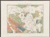
Europa ad magnae Europae Gerardi Mercatoris P. imitationem [...] [Karte], in: Gerardi Mercatoris Atlas, sive, Cosmographicae meditationes de fabrica mundi et fabricati figura, S. 61.
1 Karte aus Atlas Mercator, Gerhard Montanus, Petrus
[Karte von Europa, Zur Übersicht der Wärme-Verbreitung in diesem Erdtheile]
Erster Band, enthaltend in vier Abtheilungen die Erscheinungen der anorganischen Natur: 1. Meteorologie und Klimatographie. 2. Hydrologie und Hydrographie. 3. Geologie. 4. Tellurischer Magnetismus Humboldt, Alexander von Verlag von Justus Perthes
Europa
Atlas der Pflanzengeographie über alle Theile der Erde Rudolphi, Ludwig Verlag der Nicolaischen Buchhandlung
Europa, Staatenkarte
1 : 25000000 Europa
Europa
Schul-Atlas in 36 Karten Völter, Daniel Verlag der J.M. Dannheimer'schen Buchhandlung
[Recto], uit: Europa exactissime descripta / auctore Henrico Hondio
1 : 11500000 Annotatie: Uit: L'appendice de l'atlas de Gerard Mercator et Iudocus Hondius ... - Amsterdam : Henry Hondius, 1633; Met opdracht aan Lodewijk XIII Hondius, Henricus Amstelodami : sumptibus auctoris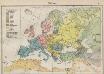
Völkerkarte von Europa
1 : 36000000 Europa Ethnische Gruppe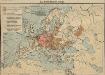
Das Deutschtum in Europa
1 : 36000000 Europa Ethnische Gruppe, Deutsche
Europe.
1 : 21542400 Lucas, Fielding Jr.
Europa um die Mitte des Vierzehnten Jahrhunderts
1 : 15000000 Europa
Machtverhältnisse der Europ. Staaten
1 : 14000000 Übersichtskarte Block, Maurice Justus Perthes
Europa
E. von Sydow's Schul-Atlas in sechs und dreissig Karten Sydow, Emil von bei Justus Perthes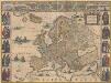
Europa recens descripta [Karte], in: Novus Atlas, das ist, Weltbeschreibung, Bd. 1, S. 22.
1 Karte aus Atlas Blaeu, Joan Blaeu, Willem Janszoon
[Verbreitung der Mammalia oder Säugethiere in Europa]
Zweiter Band, enthaltend in vier Abtheilungen die Vertheilung der Organismen: 5. Pflanzen-Geographie, 6. Thier-Geographie, 7. Anthropographie, 8. Ethnographie Humboldt, Alexander von Verlag von Justus Perthes
Europa
Hand-Atlas über alle Theile der Erde und über das Weltgebäude Stieler, Adolf Justus Perthes
Europa
Neuer Handatlas über alle Theile der Erde Kiepert, Heinrich Verlag von Dietrich Reimer
Europa
Schul-Atlas über alle Theile der Erde nach dem neuesten Zustande, und über das Weltgebäude Stieler, Adolf Justus Perthes