Maps of Belarus

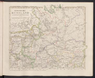
Europäisches Russland
Hand-Atlas über alle Theile der Erde nach dem neuesten Zustande und über das Weltgebäude Stieler, Adolf bei Justus Perthes
Vollstaendiger Kriegs-Schauplatz in Pohlen und Russland im Jahre 1812
1 : 2312000 Polsko im Kunst und Industrie Komptoir
[V]oll[st]and[i]ger Kriegs-Schauplatz in [P]o[h]len [und Rus]sland im Jahre [1]812
1 : 2312000 Polsko Kunst und Industrie Komptoir
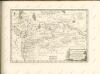
Moscoviae imperivm
1 : 11000000 1 Karte : Kupferdruck ; 20 x 27 cm Bussemacher, Johannes formulis Jani Bussemecheri
Moscovia Sigmunds Freyherrns zu Herberstain / Neyperg und Guetenhag
1 : 6400000 1 Karte : Holzschnitt ; 27 x 38 cm Herberstein, Sigmund von durch Michael Zimmermann in S. Annenhof
Russland 1462-1762
1 : 18000000 Russland
[IX], uit: Geognostische Karte des Oesterreichischen Kaiserstaates mit einem grossen Theile Deutschland's u. Italien / hauptsachlich nach ... Haidinger's geognostischer Karte dieses Staates bearb. von Josef Scheda
1 : 3000000 titelvariant: General-Karte von Europa in 25 Blättern; Annotatie: Bijlage bij: General-Karte von Europa in 25 Blättern. - 1:2.592.000. - 1845-1847 Scheda, Joseph Wien : K.K. Militär. Geografisch. Institut
Moschovia nuova tavola
1 : 11000000 1 Karte : Kupferdruck ; 19 x 24 cm Ptolemaeus, Claudius [Vincenzo Valgrisi]
Moschovia nuova tavola
1 : 11000000 1 Karte : Kupferdruck ; 19 x 24 cm Ptolemaeus, Claudius [Vincenzo Valgrisi]
Europäisches Russland
Stieler's Hand-Atlas Stieler, Adolf bei Justus Perthes
[Sarmatia Europae et Tauricam Chersonesum]
1 : 3900000 1 Karte : Holzschnitt ; 29 x 47 cm Ptolemaeus, Claudius [Gaspard Trechsel]
69-70. Russia centrale.
1 : 3000000 Touring club italiano
Europäisches Russland
Hand-Atlas über alle Theile der Erde nach dem neuesten Zustande und über das Weltgebäude Stieler, Adolf bei Justus Perthes
Eur. Russland
Rusko severní
La Moscovie septentrionale, suivant les nouvelles observations de Messrs. de L'Académie Royale de S
1 : 5800000 2 Karten auf einem Blatt : Kupferdruck ; 22 x 30 cm (gesamt, inklusive Rahmen 52 x 39) Chez Pierre vander Aa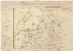
Ukazanije slavjanskago gorodstva v sevěro-zapadnoj časti Rossii
Finsko
Zweiter Theil der Karte von Europa
1 : 2870000 Dánsko Anville, Jean-Baptiste Bourguinon d' Benedicti, Hieronymus F.A. Schraembl
Carte hydrographique de la principale partie de la Russia Europeenne
1 : 3000000 Rusko západní Wiebeking, Carl Friedrich von Ranzinger, Jean
Partie septentrionale de la Russie européenne / par Robert de Vaugondy ; corrigée par le C.en Lama
1 : 7400000 1 Karte : Kupferdruck ; 23 x 30 cm Delamarche, Charles François [Verlag nicht ermittelbar]
Partie septentrionale de la Russie européenne / d'aprés le détail de l'Atlas Russien par le Sr. R
1 : 3400000 1 Karte auf 2 Blatt : Kupferdruck ; 47 x 58 cm Robert de Vaugondy, Didier [Verlag nicht ermittelbar]
Europaischen Russland I.
1 : 5000000 Handtke, Friedrich H.
Mappae Imperii Moscovitici pars Septentrionalis
1 : 2600000 adornata per Guillielmum De L'Isle nunc vero aeri incisa et venalis exposita a Matth. Seutter Aug. [Vindelicorum] : Matt. Seutter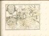

Geologičeskoe stroenīe ozernoj oblasti
Russland Russland (Nord) Geologie Geol. Komitet
Počvy ozernoj oblasti
Russland Russland (Nord) Geografie Sibircev, K.
Plemena ozernoj oblasti
Russland Russland (Nord) Ethnische Gruppe Stavrovskij, Ja.
Plotnost' naselenīja ozernoj oblasti
Russland Russland (Nord) Bevölkerungsdichte Moračevskij, V.
Rel'ef ozernoj oblasti
Russland Russland (Nord) Geografie Tillo, A. ; Šokal'skij, Ju.