Maps of Europe

Europa
Neuester Schul-Atlas Walch, Johann im Verlag bei Joh. Walch
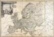
Europa delineata et recens edita per Nicolaum Visscher. [Karte], in: Novus atlas absolutissimus, Bd. 1, S. 28.
1 Karte aus Atlas Janssonius Offizin
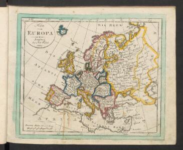
Neue Carte von Europa welche die merkwürdigsten Producte und vornehmsten Handelspläze nebst den Flächen-Inhalt aller Europäischen Länder in deutschen Quadrat-Meilen enthält
1 : 9000000 von A.F.W. Crome T.A. Pingeling sculpsit Hamburg Dessau ; [s.n.]
Nova et accurate divisa in regna et regiones praecipuas Europae descriptio
1 : 10000000 per F. de Witt Amstelodami [Amsterdam] : ex officina I. Cóvens et C. Mortier
Europa Exactissime Descripta [Karte], in: Novus atlas absolutissimus, Bd. 1, S. 25.
1 Karte aus Atlas Janssonius Offizin
Europa, nach seiner politischen Gestalt vom Jahr 1812
Historisch-genealogisch-geographischer Atlas von Le Sage Las Cases, Emmanuel Auguste Dieudonné Marius Joseph de Johann Velten, Kunsthändler
Europa
Allgemeiner Atlas [Walch, Johannes] im Verlag bei Johannes Walch
Nova Europae Descriptio [Karte], in: Gerardi Mercatoris Atlas, sive, Cosmographicae meditationes de fabrica mundi et fabricati figura, S. 64.
1 Karte aus Atlas Mercator, Gerhard Montanus, Petrus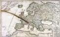
Der Austritt des Mond=Schattens von der Erd=Kugel/ oder das zum Theil eine Finsternuss leidende/ zum Theil davon frey bleibende Europa
1 Karte : Kupferdruck ; 52 x 85 cm Bodenehr zufinden bey Gabriel Bodenehr/ Kupfferst
[Evropa]
Evropa
[Recto], uit: Europa exactissime descripta / auctore Henrico Hondio
1 : 11500000 Annotatie: Uit: L'appendice de l'atlas de Gerard Mercator et Iudocus Hondius ... - Amsterdam : Henry Hondius, 1633; Met opdracht aan Lodewijk XIII Hondius, Henricus Amstelodami : sumptibus auctoris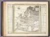
Botanisch-Geographisch-Statistische Karte Von Europa.
1 : 16000000 Berghaus, Heinrich
Accuratissima Europæ tabula
1 Karte : Kupferdruck ; 49 x 58 cm Allard ex officina I. Cóvens et C. Mortier
Nova et accurate divisa in regna et regiones præcipuas Europæ descriptio
1 Karte : Kupferdruck ; 43 x 53 cm Wit ex officina I. Cóvens et C. Mortier
Europa excultissima
1 Karte : Kupferdruck ; 48 x 57 cm Schenk Pieter Schenk
Accuratissima Europæ tabula
1 Karte : Kupferdruck ; 48 x 57 cm Allard Carel Allard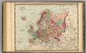
Europe.
1 : 22176000 Johnson, A.J.
General Karte von Europa
1 Karte : Kupferdruck ; 50 x 58 cm von der kön. privileg: Schneider und Weigelschen Kunst und Buchhandlung
L'Europe dans son etat actuel
1 Karte : Kupferdruck ; 47 x 61 cm Hérisson; Desray; Glot; Picquet chez Desray libraire rue Hautefeuille no. 4, chez Picquet géog.he graveur du cab. topographique de S. M. l'empereur et roi et de S. M. le roi de Hollande quai Malaquais no. 15
Ewropa
1 : 32000000 Evropa Merklas, Václav
Europa nach seinen kirchlichen Verhältnissen im Mittelalter
1 : 15000000 Europa Kirchengeschichte
Europa
1 Karte : Kupferdruck ; 45 x 53 cm Götze im Verlage des Geograph: Instituts
Europa
1 Karte : Kupferdruck ; 45 x 55 cm Götze im Verlage des Geograph. Instituts
Europa
1 Karte : Kupferdruck ; 46 x 54 cm Götze im Verlage des Geograph. Instituts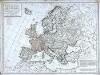
Carte politique de l'Europe
1 Karte : Kupferdruck ; 50 x 68 cm Poirson; Jean; Brion de la Tour chez Jean rue Jean de Beauvais no. 10
Carte politique hydrographique [et] routiere de l'Europe
1 Karte : Kupferdruck ; 48 x 54 cm Champion; Hinrichs chez J. C. Hinrichs libraire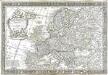
L'Europe
1 Karte : Kupferdruck ; 43 x 66 cm Nolin; Boniselle; Jean chez Jean rue Jean de Beauvais no. 32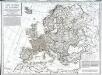
Carte politique de l'Europe
1 Karte : Kupferdruck ; 50 x 68 cm Poirson; Jean; Brion de la Tour chez Jean rue Jean de Beauvais no. 32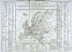
Tableau général de l'Europe
1 Karte : Kupferdruck ; 35 x 44 cm, Bildgrösse: 52 x 73 cm Brion de la Tour; Le Campion; Le Campion chés les Campion freres m.ds d'estampes rue St. Jacques près la f.e S. Severin à la ville de Rouen