Maps of Africa

Der Atlantische Ocean
Hand-Atlas über alle Theile der Erde nach dem neuesten Zustande und über das Weltgebäude Stieler, Adolf bei Justus Perthes
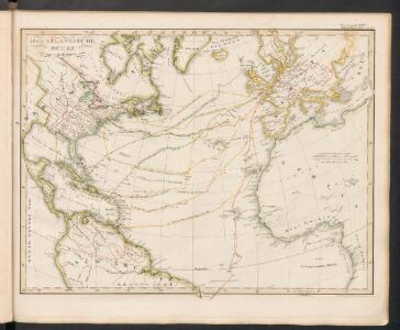
[Die Luftströmungen auf dem Nordatlantischen Ocean; Im westlichen Gebiet der Alten und im Östlichen Theil der neuen Welt]
Erster Band, enthaltend in vier Abtheilungen die Erscheinungen der anorganischen Natur: 1. Meteorologie und Klimatographie. 2. Hydrologie und Hydrographie. 3. Geologie. 4. Tellurischer Magnetismus Humboldt, Alexander von Verlag von Justus Perthes
Calculus Eclipsis Solis Observatae die 19. Novemberis 1816
Atlantic Ocean.
1 : 31000000 Johnston, Alexander Keith, 1804-1871
[Karte vom atlantischen Ocean; Zur Übersicht der Strömungen und Handelsstrassen, der Wärme-Verbreitung, des Seebodens]
Erster Band, enthaltend in vier Abtheilungen die Erscheinungen der anorganischen Natur: 1. Meteorologie und Klimatographie. 2. Hydrologie und Hydrographie. 3. Geologie. 4. Tellurischer Magnetismus Humboldt, Alexander von Verlag von Justus Perthes
Map of the United States, the British provinces, Mexico, &c. : showing the routes of the U.S. mail steam packets to California and a plan of the gold region / drawn & engraved by J.M. Atwood, New York.
from Whole
Tabula Terre Nove [Karte], in: Claudii Ptolemei viri Alexandrini mathematice discipline philosophi doctissimi geographie opus [...], S. 233.
1 Karte aus Atlas Waldseemüller, Martin [und Ptolemaeus, Claudius] Übelin, Georg
No. 1. Pacifico.
1 : 46000000 U.S. Coast and Geodetic Survey
L'Ocean.
1 : 70000000 Buache, Philippe, 1700-1773
Physical Chart of the Atlantic Ocean
The physical atlas Johnston, Alexander Keith William Blackwood & Sons
Die Luftstromungen auf dem Nordatlantishcen Ocean.
1 : 29000000 Berghaus, Heinrich
[Stromgebiete der Neuen Welt]
Erster Band, enthaltend in vier Abtheilungen die Erscheinungen der anorganischen Natur: 1. Meteorologie und Klimatographie. 2. Hydrologie und Hydrographie. 3. Geologie. 4. Tellurischer Magnetismus Humboldt, Alexander von Verlag von Justus Perthes
Der Atlantische Ocean
Hand-Atlas über alle Theile der Erde nach dem neuesten Zustande und über das Weltgebäude Stieler, Adolf bei Justus Perthes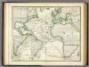
Karte vom Atlantischen Ocean.
1 : 90000000 Berghaus, Heinrich
Chart of the Atlantic Ocean, with the British, French, & Spanish settlements in North America and the West Indies : as also on the coast of Africa / by Thos. Jefferys, geographer to His Majesty.
from Atlantic Ocean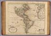
Carte d'Amerique.
1 : 31000000 L'Isle, Guillaume de, 1675-1726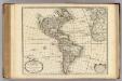
Carte d'Amerique.
1 : 31000000 L'Isle, Guillaume de, 1675-1726
Asia.
1 : 70000000 Finley, Anthony
A general chart of the West India's [sic] / by John Seller, His Maties. hydrographer.
from Atlas maritimus, or, A book of charts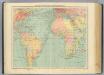
4-5. Linee di comunicazione, Oceano Atlantico.
1 : 30000000 Touring club italiano
Asia.
1 : 55000000 Lucas, Fielding Jr.
A new generall chart for the West Indies....
from English pilot. The fourth book.
Australien
Austrálie Mollo, Tranquillo bey Tranquillo Mollo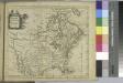
North America / drawn from the best authorities by T. Kitchin.
from A new geographical, historical, and commercial grammar : and present state of the several kingdoms of the world ... : to which are added, I. A geographical index, with the names and places alphabetically arranged ... / by William Guthrie, esq.
Nova & accuratissima totius terrarum orbis tabula nautica, 2
1 Blatt : 51 x 52 cm R. & I. Ottens
Asia.
1 : 75000000 Tanner, Henry S.
Asia.
1 : 63000000 Cummings, J. A. (Jacob Abbot)
Atlantic cables, wireless stations.
1 : 40000000 Philip, George
Asia.
1 : 65000000 Worcester, J. E.