Maps of United States

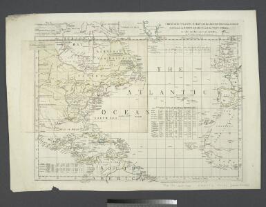
Chart of the Atlantic Ocean, with the British, French, & Spanish settlements in North America and the West Indies : as also on the coast of Africa / by Thos. Jefferys, geographer to His Majesty.
from Atlantic Ocean
[Stromgebiete der Neuen Welt]
Erster Band, enthaltend in vier Abtheilungen die Erscheinungen der anorganischen Natur: 1. Meteorologie und Klimatographie. 2. Hydrologie und Hydrographie. 3. Geologie. 4. Tellurischer Magnetismus Humboldt, Alexander von Verlag von Justus Perthes
Asia (political).
1 : 43819000 Fisher, Richard Swainson
Carte de l'Asie.
1 : 25000000 Robert de Vaugondy, Gilles, 1688-1766
Asia.
1 : 48000000 Mitchell, Samuel Augustus
Asia.
1 : 45000000 Tanner, Henry S.
Asia.
1 : 30000000 Andree, Richard; Times (London, England)
A new generall chart for the West Indies....
from English pilot. The fourth book.
Asia.
1 : 55000000 Lucas, Fielding Jr.
Asia.
1 : 37000000 Stulpnagel, F.v.
Bez titulu: Mapy kontinentů

Carte d'Amérique
1 Karte : Kupferdruck ; 46 x 59 cm L'Isle; Buache; Dezauche chez l'auteur rue des Noyers
Asia.
1 : 50000000 D.F. Robinson & Co.
Asia.
1 : 57000000 Carey, Mathew
Asia.
1 : 56000000 Carey, Mathew
Mexico, or, New Spain.
from Atlas minimus, or, A book of geography : shewing all the empires, monarchies, kingdomes, regions, dominions, principalities and countries, in the whole world / by John Seller ...
Asia.
1 : 95000000 Brudin, J. L.; Stieler, Adolf
Accuratissima totius Asiae tabula / in omnes partes divisa, de novo correcta, ac in lucem edita per
1 : 22000000 1 Karte : Kupferdruck ; 47 x 56 cm Wit, Frederick de F. de Wit excudit
Asia.
1 : 70000000 Finley, Anthony
Map of the United States, the British provinces, Mexico, &c. : showing the routes of the U.S. mail steam packets to California and a plan of the gold region / drawn & engraved by J.M. Atwood, New York.
from Whole
Asia.
1 : 48000000 Tanner, Henry S.
Asia.
1 : 48000000 Tanner, Henry S.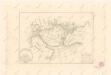
Calculus Eclipsis Solis Observatae die 19. Novemberis 1816
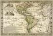
L'Amerique meridionale et septentrionale
1 Karte : Kupferdruck ; 42 x 63 cm, Bildgrösse 48 x 70 cm Desbois; Danet chez Desbois rue S. Jacques a la sphere royale
Asia / ex magna orbis terr[ae] descriptione Gerardi Mercatoris desumpta, studio et industria G. M. i
1 : 28000000 1 Karte : Kupferdruck ; 36 x 45 cm Mercator, Gerhard [Jodocus Hondius]
Asia.
1 : 63000000 Cummings, J. A. (Jacob Abbot)
Carte d'Amérique
1 Karte : Kupferdruck ; 49 x 67 cm Poirson; Jean chez Jean rue Jean de Beauvais no. 32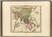
Asia.
1 : 36000000 Tanner, Henry S.
Carte d'Amérique
1 Karte : Kupferdruck ; 46 x 59 cm L'Isle; Buache; Dezauche chez l'auteur rue des Noyers