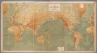
Maps of Seven Seas (Open Ocean)

L'Ocean.
1 : 70000000 Buache, Philippe, 1700-1773
Atlantic Ocean.
1 : 49000000 Goodrich, S.G.
Carte physique de l'ocean où l'on voit des grandes chaînes de montagnes qui traversent les continents d'Europe, d'Afrique et d'Amérique
1 Karte : Kupferdruck ; 27 x 34 cm, Blattgrösse 47 x 62 cm Buache; Desbruslins Philippe Buache
Atlantischer Ocean
E. von Sydow's Schul-Atlas in sechs und dreissig Karten Sydow, Emil von bei Justus Perthes
Atlantic Ocean.
1 : 31000000 Johnston, Alexander Keith, 1804-1871
Calculus Eclipsis Solis Observatae die 19. Novemberis 1816

Atlantic Ocean.
1 : 95000000 Huntington, Hezekiah, 1795-1865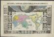
Le monde ou panorama géographique du globe terrestre, représentant les terres et les mers du globe, ses accidents physiques, les phénomènes, les règnes de la nature [...]
1 : 177600000 réd. d'après Mr. De Humbold et les savans les plus distingués par E. Hocquart [S.l.] : [s.n.]
Atlas über die Entwicklung von Industrie und Handel der Schweiz in dem Zeitraume vom Jahr 1770 bis zum Jahr 1870
1 : 45000000 1 Atlas ([3], VIII Bl.) im Auftrage der schweizerischen Commission für die additionellen Ausstellungen in Wien, bearbeitet von Dr. Hermann Wartmann Wurster Randegger & Co., Winterthur
Die Vulkanischen Erscheinungen Der Atlen Welt.
1 : 65000000 Berghaus, Heinrich
Animals - World.
Woodbridge, William C.
Karte vom Atlantischen Ocean.
1 : 90000000 Berghaus, Heinrich
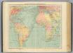
America
A new general atlas of modern geography, consisting of a complete collection of maps of the four quarters of the globe Wyld, James James Wyld
245-246. Atlantic Ocean. The World Atlas.
1 : 40000000 USSR (Union of Soviet Socialist Republics).
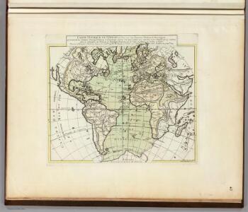
Mappe-Monde = Geo-Hydrographique, ou Descritption Generale Du Globe Terrestre Et Aquatique En Deux-Plans-Hemispheres. [Karte], in: Atlas nouveau, contenant toutes les parties du monde [...], Bd. 1, S. 32.
1 Karte aus Atlas Sanson, Nicolas Jaillot, Alexis Hubert und Mortier, Pieter
Inhabited World.
1 : 93000000 Woodbridge, William C.
Isothermal chart, productions.
1 : 80000000 Woodbridge, William C.
Isothermal chart.
1 : 95000000 Woodbridge, William C.
[Karte vom atlantischen Ocean; Zur Übersicht der Strömungen und Handelsstrassen, der Wärme-Verbreitung, des Seebodens]
Erster Band, enthaltend in vier Abtheilungen die Erscheinungen der anorganischen Natur: 1. Meteorologie und Klimatographie. 2. Hydrologie und Hydrographie. 3. Geologie. 4. Tellurischer Magnetismus Humboldt, Alexander von Verlag von Justus Perthes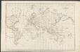
Allgemeine Weltcharte
1 : 45400000 nach Mercators Projection entworfen von A.I. Krusenstern, Capitain der Russischen Marine J. Walker sculpt. ; verb. bis zum Jahre 1818. London : [s.n.]
Composite: Pacific Ocean.
1 : 25000000 John Bartholomew and Son
Objevy zemí na hranici středního a nového věku
Weltkarte zur Übersicht der Meerestiefen & Höhenschichten, mit Angabe der unterseeischen Telegraphen-Kabel und Überland-Telegraphen, sowie der Kohlenstationen & Docks / bearb. u. gez. v. K. Blume ; gestochen im Atelier v. H. Petters
1 : 28000000 Blume, K.; Petters, H. Berlin : Hydrographisches Amt des Reichs-Marine-Amts [etc.]

Physical Chart of the Atlantic Ocean
The physical atlas Johnston, Alexander Keith William Blackwood & Sons
Australia y Oceania
1 mapa. Datat al s.XIX. 0 Gras y compañia, editores. Madrid
Oceanica.
1 : 66000000 Mitchell, Samuel Augustus
Longueurs du pendule.
1 : 75000000 L'Isle, Guillaume de, 1675-1726
Calculus Eclipsis Solis Observatae die 19. Novemberis 1816