Maps of Auvergne-Rhône-Alpes

[Frankreich in 4 Blättern, Südöstliches Frankreich]
Hand-Atlas über alle Theile der Erde und über das Weltgebäude Stieler, Adolf Justus Perthes
Carte de la République française, 4
1 Blatt : 42 x 51 cm P.G. Chanlaire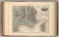
France S.E.
1 : 1615000 Migeon, J.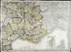
Carte de la France, 4
1 Blatt : mehrfarbig ; 61 x 82 cm de Belleyme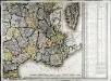
Carte de la France, 4
1 Blatt : 61 x 83 cm de Belleyme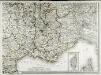
Carte de la France, 4
1 Blatt : 61 x 83 cm de Belleyme
Vorstellvng des Weges den Hannibal genom[m]en durch Gallien und über die Alpen bis in Italien
1 : 2650000 Alpy Baumgarten, Siegmund Jakob Glasser, I. F. Johann Justinus Gebauer
Frankreich SO.
1 : 1700000 Handtke, Friedrich H.
France.
1 : 4400000 Vivien de St Martin, L.

IX, uit: General-Karte von Mittel-Europa in 12 Blättern, im Masse 1:1.200.000 / entworfen, bearb. und hrsg. von Josef Schlacher
1 : 1200000 Annotatie: Blad 6 ontbreekt; Annotatie geografische gegevens: 21 maatstokken op blad 9; Legenda op blad 9 Wien : K.K. Militär Geografisches Institut
[Frankreich in 4 Blättern, Blatt 4]
Handatlas über alle Theile der Erde und über das Weltgebäude Stieler, Adolf Justus Perthes
[Frankreich, Blatt 4]
Adolf Stieler's Handatlas über alle Theile der Erde und über das Weltgebäude Stieler, Adolf Justus Perthes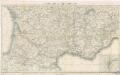
Reisekarte von Süd - Frankreich

Frankreich In 4 Blattern, Blatt 4.
1 : 1500000 Vogel, C.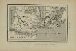
Marche des Visigoths en Gaule
Frankreich Gallien Westgoten Völkerwanderungszeit Völkerwanderung
Les royau.mes de Bourgogne, et d'Arles
1 Karte : Kupferdruck ; 39 x 49 cm, Bildgrösse 40 x 56 cm Duval chez l'auteur en l'isle du Palais sur le quay de l'Orloge au coin de la rüe de Harlay
Le royaume de France, 5
1 Blatt : 48 x 42 cm Jaillot
Postkarte von Frankreichs südoestlichen Departements oder von Languedoc, Provence, Delphinat und Savoyen
Dauphiné (Francie) Müller, Franz im von Reillyschen Landkarten und Kunstwerke Verschleiss Komptoir
France Flle. S.E.
1 : 1000000 Vivien St Martin, L.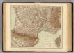
France S., Corsica.
1 : 1750000 Andree, Richard; Times (London, England)
Théatre de la guerre en Italie ou le cours du Rhone
1 Karte : Kupferdruck ; 54 x 68 cm Poirson; Jean; Macquet; Tardieu chez Jean M.d d'estampes rue S. Jean de Beauvais n.o 4
Théatre de la guerre en Italie ou le cours du Rhone
1 Karte : Kupferdruck ; 54 x 68 cm Poirson; Jean; Macquet; Tardieu chez Jean M.d d'estampes rue S. Jean de Beauvais n.o 4
France II.
1 : 1770000 Society for the Diffusion of Useful Knowledge (Great Britain)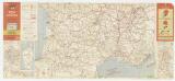
Etat des routes : hôtels, bonnes tables, mécaniciens, routes enneigées
1 : 1000000 Annotatie: Met aansluitende bijkaart van Corsica Paris : Services de Tourisme Michelin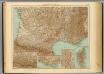
35-36. Francia sud.
1 : 1500000 Touring club italiano
Partie, la France. Europe 19.
1 : 1641836 Vandermaelen, Philippe, 1795-1869
Der südliche Theil von Frankreich nebst einem Theile von Spanien

Der Südliche Theil von Frankreich nebst einem Theile von Spanien
Stieler's Hand-Atlas Stieler, Adolf bei Justus Perthes
![[Frankreich in 4 Blättern, Südöstliches Frankreich]](https://images-2.georeferencer.com/images/iiif/182377960367/full/,300/0/native.jpg)

