Maps of Brazilian Highlands

[Süd-Amerika in 6 Blättern, Blatt 4]
Adolf Stieler's Handatlas über alle Theile der Erde und über das Weltgebäude Stieler, Adolf Justus Perthes
Paskaert van Brasilia van Pernambuco tot C. de S. Antonio
1 Karte : Kupferdruck ; 43 x 53 cm Doncker bÿ Hendrick Doncker
Brasil du Sud.
1 : 6000000 Vivien St Martin, L.
S. Brazil, Paraguay, Uruguay.
1 : 6630000 Society for the Diffusion of Useful Knowledge (Great Britain)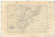
Brésil et pays des Amazones, avec le gouvernement de Buenos-Aires
1 : 10700000 Amazonka-oblast Bonne, Rigobert André
South America 4.
1 : 6969600 Letts, Son & Co.
South America 4.
1 : 2800000 Arrowsmith, Aaron
Novus Brasiliae Typus
Blaeu, Willem Janszoon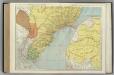
Brazil, Paraguay, and Uruguay (southern half).
1 : 5020000 Rand McNally and Company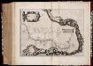
Maritima Brasiliæ universæ / [Joan Blaeu]
1 : 6375000 Annotatie: Kaart vertoont de plaatsen aan de westkust van Brazilië; Origineel is Blad 216 in atlas factice; Annotatie geografische gegevens: Schaalstokken op kaart: 60 Milliaria Germanica 15 uni gradui respondentia (=7,2 cm), en: 70 Milliaria Hispanica 17 1/2 gradui respondentia (=7,2 cm); West boven Joan Blaeu 1597/98-1673 [Amsterdam] : [Blaeu]
Accuratissima Brasiliae Tabula. [Karte] Baya de todos os Sanctos [Nebenkarte] Villa d'Olinda de Pernambuco [Nebenkarte], in: Gerardi Mercatoris et I. Hondii Newer Atlas, oder, Grosses Weltbuch, Bd. 2, S. 407.
1 Karte aus Atlas Mercator, Gerhard und Hondius, Jodocus Jansson, Jan
Accuratissima Brasiliae tabula
1 : 4000000 Henricus Hondius excudit Amstelodami : Henricus Hondius
Brazil - East - Central. Pergamon World Atlas.
1 : 5000000 Polish Army Topography Service
A map of Brazil, now called New Portugal
1 : 9600000 Carey, Mathew, 1760-1839 M. Carey
Paraquariae Provinciae.
1 : 5700000 Petroschi, Giovanni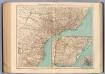
157-58. Brasile Meridionale, Uruguay.
1 : 3000000 Touring club italiano
Novus Brasiliae Typus [Karte] [Baya de todos os Sanctos] [Nebenkarte], in: Novus Atlas, das ist, Weltbeschreibung, Bd. 2, S. 343.
1 Karte aus Atlas Blaeu, Joan Blaeu, Willem Janszoon
Maritima Brasiliae Universae
Blaeu, Joan [Blaeu]
L. Das kaiserthum Brasilien. Provinz 13-14, 15, 19. Q. Die Rep. Montevideo
1 : 2000000 Schlieben, Wilhelm Ernst August von (1781 - 1839)
Mapa geologico do estado de Minas Geraes
1 : 1000000 Guimarães, Djalma Belo-Horizonte : Imprensa Official
229. Brazil, South East, Sao Paulo Region, Rio de Janeiro. The World Atlas.
1 : 3750000 USSR (Union of Soviet Socialist Republics).
Estado de Sao Paulo, mappa geologico physico politico e economico
1 : 1000000 Paris : Girard et Barrère
De kust van Brazielia vertoonende de klippen van de Abreolhos int grood
Brazil Gerard van Keulen
Carta de progresso da Commissao Geographica e Geologica de S. Paulo
1 : 2000000 Comissão Geográfica e Geológica. São Paulo, Brésil [São Paulo] : Commissão Geográphica e Geológica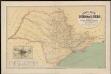
Carta geral do estado de Sao Paulo. Organizada pela Commissao Geographica e Geologica
1 : 1000000 Comissão Geográfica e Geológica. São Paulo, Brésil São Paulo : Weiszflog Irmãos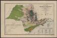
Carta geral do estado de Sao Paulo. Com indicaçoes sobre a agricultura, commercio, instrucçao publica, industria e colonisaçao
1 : 2000000 Comissão Geográfica e Geológica. São Paulo, Brésil [São Paulo] : Commissão Geográphica e Geológica
Partie du Bresil. Amer. Merid. 23.
1 : 1641836 Vandermaelen, Philippe, 1795-1869
Partie du Bresil. Amer. Merid. 24.
1 : 1641836 Vandermaelen, Philippe, 1795-1869
Partie du Bresil. Amer. Merid. 27.
1 : 1641836 Vandermaelen, Philippe, 1795-1869
![[Süd-Amerika in 6 Blättern, Blatt 4]](https://images-2.georeferencer.com/images/iiif/118433275935/full/,300/0/native.jpg)

