Maps of United States

Die Atlantischen Staaten zwischen Washington & Boston, Blatt 1]
Adolf Stieler's Handatlas über alle Theile der Erde und über das Weltgebäude Stieler, Adolf Justus Perthes
West-Indien, Central-Amerika bis zum südlichen Canada in 4 Blättern
1 : 7500000 Nordwest-Blatt Petermann, August Heinrich ; Habenicht, H. Justus Perthes
North America, 1710.
1 : 13500000 Senex, John
Composite: U.S. West of Mississippi R.
1 : 2000000 Freyhold, Edward; Warren, Gouverneur Kemble, 1830-1882; United States. Army. Corps of Engineers
A New Map of Texas Oregon and California With The Regions Adjoining.
1 : 6652800 Mitchell, Samuel Augustus
A New Map of The States Of Texas & California
1 : 6652800 Mitchell, Samuel Augustus
Map Of The United States.
1 : 6000000 Emory, William H.
U.S. Western.
1 : 8870400 Letts, Son & Co.
A New Map of Texas Oregon and California With The Regions Adjoining.
1 : 6652800 Mitchell, Samuel Augustus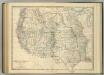
Western United States.
1 : 6047811 Johnston, Alexander Keith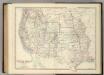
Western United States.
1 : 6047811 Johnston, Alexander Keith
National Map Of The Territory Of The United States.
1 : 3801600 Keeler, William J.
Map Of The Territory Of The United States From The Mississippi To The Pacific.
1 : 3000000 Warren, Gouverneur Kemble, 1830-1882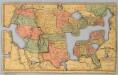
Map of the United States and Canada.
1 : 11404800 Merriam, Moore & Co.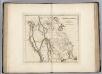
Missouri Territory formerly Louisiana.
1 : 9900000 Carey, Mathew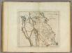
Missouri Territory formerly Louisiana.
1 : 10000000 Carey, Mathew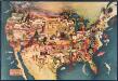
Paul Sample's America: Its Soil
This bird's-eye-view map shows scenes of land use and farming superimposed on a map of the United States. Agricultural scenes of farming, livestock, and crops are depicted. Sample, Paul Associatedd American Artists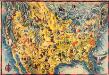
The Covarrubias America: a decorative map of the United States of America
This pictorial bird's-eye-view map shows the United States of America with parts of Canada and Mexico. Landscape, trade, industry, points of interest, people, and animals are depicted. Covarrubias, Miguel Edward Stern & Co.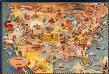
Bohrod's America, its history
This map shows scenes from America's history with names of historical events superimposed on a map of the United States. Bohrod, Aaron Associated American Artists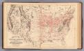
Railroad map U.S.
1 : 7850000 Mitchell, Samuel Augustus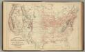
Railroad map U.S.
1 : 7850000 Mitchell, Samuel Augustus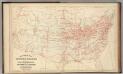
Railroad map U.S.
1 : 7850000 Mitchell, Samuel Augustus Jr.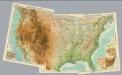
Composite: United States.
1 : 5000000 John Bartholomew & Co.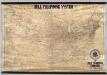
Lines Of The Bell Telephone Companies. United States And Canada.
1 : 2471040 American Telephone and Telegraph Company
Road map United States.
1 : 7500000 Rand McNally and Company
United States.
1 : 5000000 Rand McNally and Company
New railroad map of the United States, and Dominion of Canada.
1 : 7000000 Warner & Beers
United States W.
1 : 4748000 Johnston, Alexander Keith, 1804-1871
Map Of The Territory Of The United States From The Mississippi River To The Pacific Ocean.
1 : 3041280 Warren, Gouverneur Kemble, 1830-1882
![Die Atlantischen Staaten zwischen Washington & Boston, Blatt 1]](https://images-2.georeferencer.com/images/iiif/937481677057/full/,300/0/native.jpg)

