Maps of United States

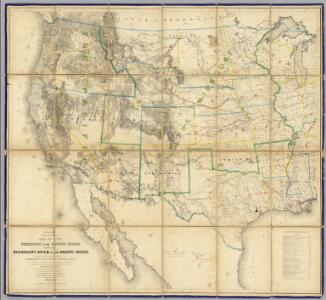
Map Of The Territory Of The United States From The Mississippi River To The Pacific Ocean.
1 : 3041280 Warren, Gouverneur Kemble, 1830-1882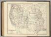
Western United States.
1 : 6047811 Johnston, Alexander Keith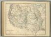
Western United States.
1 : 6047811 Johnston, Alexander Keith
National Map Of The Territory Of The United States.
1 : 3801600 Keeler, William J.
Reduced section, map of North America, 1826.
1 : 18000000 Warren, Gouverneur Kemble, 1830-1882
Reduced section, territory west of Rocky Mountains, 1837.
1 : 18000000 Warren, Gouverneur Kemble, 1830-1882
Reduced section, general map, North America, 1795.
1 : 18000000 Winterbotham, W.
Map Of The Territory Of The United States From The Mississippi To The Pacific Ocean.
1 : 3000000 Warren, Gouverneur Kemble, 1830-1882
Map Of The Territory Of The United States From The Mississippi To The Pacific Ocean.
1 : 3000000 Warren, Gouverneur Kemble, 1830-1882
Map Of The United States.
1 : 6000000 Emory, William H.
Map Of The Territory Of The United States From The Mississippi To The Pacific.
1 : 3000000 Warren, Gouverneur Kemble, 1830-1882
United States W.
1 : 4748000 Johnston, Alexander Keith, 1804-1871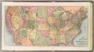
New Railroad Map of the United States & Territories.
1 : 5000000 Cram Atlas Company
Die Atlantischen Staaten zwischen Washington & Boston, Blatt 1]
Adolf Stieler's Handatlas über alle Theile der Erde und über das Weltgebäude Stieler, Adolf Justus Perthes
1882. Progress Map Of The U.S. Geographical Surveys West Of The 100th Meridian.
1 : 6000000 Wheeler, G.M.
1880. Progress Map Of The U.S. Geographical Surveys West Of The 100th Meridian.
1 : 6000000 Wheeler, G.M.
1878. Progress Map Of The U.S. Geographical Surveys West Of The 100th Meridian.
1 : 6000000 Wheeler, G.M.
1878. Progress Map Of The U.S. Geographical Surveys West Of The 100th Meridian.
1 : 6000000 Wheeler, G.M.
1878. Progress Map Of The U.S. Geographical Surveys West Of The 100th Meridian.
1 : 6000000 Wheeler, G.M.
1876. Progress Map Of The U.S. Geographical Surveys West Of The 100th Meridian.
1 : 6000000 Wheeler, G.M.
1875. Progress Map Of The Geographical Surveys West Of The 100th Meridian.
1 : 6000000 Wheeler, G.M.
Map Of The Areas Of Drainage To The Atlantic And Pacific Oceans.
1 : 6000000 Wheeler, G.M.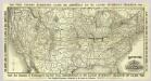
Map Ohio & Mississippi Railway.
1 : 7897000 Ohio and Mississippi Railway
Composite: U.S. West of Mississippi R.
1 : 2000000 Freyhold, Edward; Warren, Gouverneur Kemble, 1830-1882; United States. Army. Corps of Engineers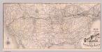
Map Great Western Railway of Canada.
1 : 7501800 Great Western Railway Company (Canada)
West-Indien, Central-Amerika bis zum südlichen Canada in 4 Blättern
1 : 7500000 Nordwest-Blatt Petermann, August Heinrich ; Habenicht, H. Justus Perthes
U.S. Western.
1 : 8870400 Letts, Son & Co.
Vital statistics, United States census, 1870. Deaths from consumption ... malarial diseases, fevers, intestinal diseases.
1 : 15000000 Baskin, Forster and Company
United States census maps, 1870: foreign, density, colored, Irish and German.
1 : 16900000 Warner & Beers
Agriculture and wealth by colors. Wealth. Cotton. Tobacco. Dairy products.
1 : 16900000 Warner & Beers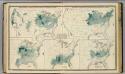
Agricultural productions colored by grades to show quantity raised in localities. Wheat, hay, corn, cotton, tobacco.
1 : 15000000 Baskin, Forster and Company
United States vitality maps, compiled from the Census of 1870.
1 : 16900000 Warner & Beers
Vital statistics, United Census, 1870: Deaths from ... diseases.
1 : 14000000 Andreas, A. T. (Alfred Theodore), 1839-1900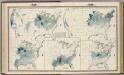
Agricultural productions colored by grades to show quantity raised in localities. Wheat, hay, corn, cotton, tobacco.
1 : 14000000 Andreas, A. T. (Alfred Theodore), 1839-1900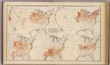
Agricultural productions colored ... to show quantity raised ... wheat, hay, corn, cotton, tobacco.
Andreas, A. T. (Alfred Theodore), 1839-1900