Maps of Greenland

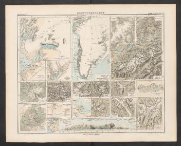
Gletscherkarte
Atlas der Geologie Zittel, K.v. ; Berghaus, Hermann Justus Perthes
Pas-caerte van Groenlandt, Yslandt, Straet Davids en Ian Mayen Eylant
1 Karte : Kupferdruck ; 43 x 52 cm Doncker bÿ Hendrick Doncker boekverkoper en graadbooghmaker inde Nieubrughsteegh
A General Chart ... Davis Straits & Baffin Islands Bay.
1 : 19000000 Melish, John
Groenland und die angraenzenden Laender nach den Charten und Berichten von Cranz, Egede, Gieseke, Graah, Olavsen, Parry, Ross, Scoresby, Thorhallesen u.a.
1 : 5000000 entworfen und gezeichnet von Theodor Gliemann Weimar : Verlag des Geograph. Instituts
Gletscherkarte.
Berghaus, Hermann
Carte marine, de la B. de Baffin, et une partie d'Hudson, d'Island et Groenland
1 Karte : Kupferdruck ; 42 x 48 cm Königliche Akademie der Wissenschaften
Nieuwe afteekening van de Straat Davits van Hitland tot aen de Straet Davids
Atlantic Ocean Gerard van Keulen
Typus Maritimus Groenlandiae, Islandiae, Freti Davidis, Insulae Iohannis Mayen, et Hitlandiae, Scotiae, et Hiberniae litora maritima Septentrionalia
1 : 7000000 Annotatie: Paskaart van de noordelijke Atlantische Oceaan met de kusten van met name het gebied tussen de Faeroër Eilanden, Groenland en Baffin Island; Origineel is Blad 149 in atlas factice; Kaart bevat diverse kompasrozen en is gedecoreerd met afbeeldingen van schepen en een walvis; Annotatie geografische gegevens: Met drie schaalstokken [Amstelodami] : [Apud Ioannem Ianßonium]
Greenland, Labrador.
1 : 15000000 Peterson, Augusts
Carte réduite des mers du Nord
1 Karte : Kupferdruck ; 54 x 76 cm Verdun de la Crenne; Borda; Pingré; Petit s.n.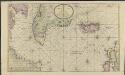
Nieuwe platte pas kaart van de Noord Occiaan van Hitland tot in de Straat Davids seer dienstig voor de Straat Davids vaarders
1 : 3800000 welke straat nu nieulijks en naaukeurig afgeteekent en beschreeven door schipper Laurens Feykes Haan en verder in 't ligt gebragt door G. van Keulen Tot Amsterdam : bij Gerard van Keulen, boek en zee-kaart verkooper, aan de Nieuwen-brug [...]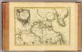
L'Amerique Septentrionale 1.
1 : 10050000 Bonne, Rigobert, 1727-1794
Septemtrionaliora Americæ à Groenlandia, per freta Davidis et Hudson, ad Terram Novam
1 Karte : Kupferdruck ; 48 x 55 cm Renard Louis Renard
Pascaert om van Texel na de Straet Davids en Hutson te zijlen zijnde ook seer dienstig voor de gene die agterom koomen voornamentlijk voor de Westindise en Guneese schipvaert
Atlantic Ocean Gerard van Keulen
Old Greenland.
1 : 9850000 Bowen, Emanuel
Paskaert van de Noordelijckste kuste van America van Groenland door de Straet Davis en de Straet Hudson tot Terra Neuf
1 : 8000000 Colom, Jacob Aertsz Colom, Jacob Aertsz
Museumskart 15 Nieuwe Wassende kaart van een Gedeelte der Noorder Atlantische Oceaan
1 : 3000000 Gerard Hulst van Keulen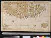
Oud Groenland van Staaten Hoek of C. Farawel tot de Visch Baij of Straet Davids int groot
Greenland Gerard van Keulen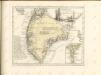

Feuille 1 (A I), uit: Carte géologique internationale de l'Europe : la carte, votée au congrès géologique international de Bologne en 1881, est exécutée conformément aux décisions d'une commission internationale, avec le concours des gouvernements, sous le dir. de M.M. Beyrich et Hauchecorne
Annotatie: Blad 48 gamme des couleurs; blad 49: bladwijzer en titelblad Heinrich Ernst Beyrich 1815-1896; Wi. Hauchecorne Berlin : Reimer / (Berlin: Institut lithographique)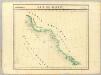
Baie de Baffin. Amer. Sep. 3.
1 : 1641836 Vandermaelen, Philippe, 1795-1869
Feuille 2 (B I), uit: Carte géologique internationale de l'Europe : la carte, votée au congrès géologique international de Bologne en 1881, est exécutée conformément aux décisions d'une commission internationale, avec le concours des gouvernements, sous le dir. de M.M. Beyrich et Hauchecorne
Annotatie: Blad 48 gamme des couleurs; blad 49: bladwijzer en titelblad Heinrich Ernst Beyrich 1815-1896; Wi. Hauchecorne Berlin : Reimer / (Berlin: Institut lithographique)
Baffin Bay journey.
1 : 3200000 Hayes, Isaac Israel
Ireland.
1 : 1950000 Bowen, Frances
Karten-Skizze des Treibeises bei Newfundland während der Zeit vom 11. März bis zum 5. Mai 1891, nach den Berichten, welche bis zum 20. Mai eingegangen sind
Newfoundland (Kanada : ostrov)
Karten-Skizze des Treibeises bei Newfundland während der Zeit von Anfang Mai bis Ende Juni, nach den Berichten, welche bis zum 8ten Juli eingegangen sind
Newfoundland (Kanada : ostrov)
North America polar regions : Baffin Bay to Lincoln Sea showing the most recent discoveries including those of U.S.S. Polaris Expedition in 1871-2, under Captain C.F. Hall, British Arctic Expedition in 1875-6, under Captain G.S. Nares, R.N., The Lady Franklin Bay Expedition in 1881-4, under Lieutenant A.W. Greely, U.S.A
1 : 1500000 United States. Hydrographic Office Hydrographic Office, Navy Dept.
Carte generale de toute l'Europe, 1
1 Blatt : 57 x 48 cm J.M. Will
[II], uit: Geognostische Karte des Oesterreichischen Kaiserstaates mit einem grossen Theile Deutschland's u. Italien / hauptsachlich nach ... Haidinger's geognostischer Karte dieses Staates bearb. von Josef Scheda
1 : 3000000 titelvariant: General-Karte von Europa in 25 Blättern; Annotatie: Bijlage bij: General-Karte von Europa in 25 Blättern. - 1:2.592.000. - 1845-1847 Scheda, Joseph Wien : K.K. Militär. Geografisch. Institut