Maps of South America

[Carte de l'Empire Espagnol dans les deux Amériques en 1776]
1 : 2000000 Description géographique et statistique de la Confédération Argentine Martin de Moussy, Victor Librairie de Firmin Didot frères, fils et Cie
Karte von Amerika
1 : 20000000 Aljaška Reilly, Franz Johann Josef von Anville, Jean-Baptiste Bourguinon d' Reillyschen Landkarten und Kunstwerke Verschleiss Komptoir

(L'Amerique)
1 : 150000000 Bruyset, Jean-Marie; Schneider, J. H.
America
Stieler's Hand-Atlas Stieler, Adolf bei Justus Perthes
Carte de l'Empire Espagnol dans les deux Ameriques.
1 : 24000000 Martin de Moussy, V. (Victor), 1810-1869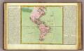
L'Amerique isles, caps, ports.
1 : 57000000 Clouet, J. B. L. (Jean-Baptiste Louis), b. 1730

Amérique septentrionale et méridionale
1 Karte auf 4 Blatt : Kupferdruck ; 96 x 110 cm Robert de Vaugondy; Arrivet chés l'auteur quai de l'horloge du Palais près le Pont-neuf
L'Amerique.
1 : 36000000 Buchon, J. A. C.; Carey, H. C.; Lea, I.
America.
1 : 26500000 Arrowsmith, John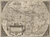
Americae Sive Novi Orbis, Nova Descriptio. [Karte], in: Theatrum orbis terrarum, S. 61.
1 Karte aus Atlas Ortelius, Abraham Vrients, Jan Baptista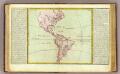
L'Amerique lacs, fleuves ...
1 : 46000000 Clouet, J. B. L. (Jean-Baptiste Louis), b. 1730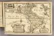
L'Amerique.
1 : 64000000 Fer, Nicolas de, 1646-1720
America
1 Karte : Kupferdruck ; 51 x 59 cm Mannert; Gatterer; Raynal; Arrowsmith bey Adam Gottlieb Schneider u: Weigel
America noviter delineata
Mapa holandés de América elaborado durante la Guerra de Flandes o Guerra de los Ochenta Años(1568-1648) que enfrentó a España con las Provincias Unidas neerlandesas de los Países Bajos. El énfasis del mapa en los barcos y en los monstruos marinos probablemente simbolice los peligros del mar durante esta guerra y resalte el poderío naval neerlandés y su proyecto de colonización de América. El mapa continentecaníbales en Brasil, gigantes en la Patagonia, y la ciudad Dorada del Lago Parime, representaciones constantes en los mapas y el imaginario europeo sobre el Nuevo Mundo del siglo XVII. Los territorios de la actual Colombia, aparecen denominados como “Castilla del Oro”, como era común en los mapas neerlandeses de la época. El mapa incluye dos mapas insertos: uno en la parte inferior izquierda, que muestra el continente austral, entonces desconocido por los europeos, denominado “terra australis incognita” y que viene acompañado de una anotación dónde se resalta lo maravilloso y desconocido del continente austral: “Tabellam hanc seorsim subiunximus ex qua quanta pars orbis austrum versus in hunc usque diem nos lateat perspicuum est”. El otro inserto en la parte norte del continente americanocontiene una anotación sobre el poco conocimiento que entonces tenían los europeos de las regiones boreales de Norteamérica: “Borealis America tractus cum hac tabula comprehendi nequirent nisi forteistas regiones minoris forme ambitu concludere et describere voluissemus nos ijs tabellam seorsim destinavimus supra delineatam cui et polus articus includitur”. Tipo: Mapa impreso, grabado en cobre, proveniente de un atlas. Hondius, Hendrik (1597-1651) Jansson(ius), Joannes (1588-1664)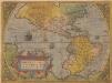
Americae Sive Novi Orbis, Nova Descriptio. [Karte], in: Theatrum orbis terrarum, S. 16.
1 Karte aus Atlas Ortelius, Abraham
La America
1 Karte : Kupferdruck ; 45 x 51 cm s.n.
America
Hand-Atlas über alle Theile der Erde und über das Weltgebäude Stieler, Adolf Justus Perthes
AMERICÆ | nova Tabula
Auct: Guiljelmo Blaeuw [Amsterdam : Joan Blaeu]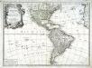
L'Amerique divisée en ses principaux etats
1 Karte : Kupferdruck ; 45 x 62 cm Janvier; Santini; Remondini chez Mr. Remondini
America
Hand-Atlas über alle Theile der Erde nach dem neuesten Zustande und über das Weltgebäude Stieler, Adolf bei Justus Perthes
America / by H. Moll, geographer, 1726.; A set of thirty-two new and correct maps of the principal parts of Europe, &c.: with the great or post-roads, and principal cross-roads, done in the year 1725, 1726 and 1727: all except four, viz. England, Scotland, Ireland, and a general map of Turky in Europe, which have been done and printed before ... / all done according to the latest observations, by Herman Moll, geographer.
from A set of thirty-two new and correct maps of the principal parts of Europe, &c. : with the great or post-roads, and principal cross-roads, done in the year 1725, 1726 and 1727 : all except four, viz. England, Scotland, Ireland, and a general map of Turky in Europe, which have been done and printed before ... / all done according to the latest observations, by Herman Moll, geographer. Moll, Herman,
Amerique.
1 : 26000000 Garnier, F. A., 1803-1863
Amérique historique, physique et politique actuelle
Amerika Renouard, Paul Paul Renouard

America
1 : 28000000 Amerika Weiland, Karl Ferdinand Geographisches Institut
Americae mappa generalis
1 Karte : Kupferdruck ; 45 x 51 cm Haas; Böhme Homännische Erben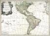
L'Amerique divisée en ses principaux etats
1 Karte : Kupferdruck ; 46 x 64 cm Janvier; Lattré; Choffard chés Lattré graveur rue St. Jacques au coin de celle de la parcheminerie à la ville de Bordeaux
![[Carte de l'Empire Espagnol dans les deux Amériques en 1776]](https://images-2.georeferencer.com/images/iiif/811658430212/full/,300/0/native.jpg)

