Maps of South America


America.
1 : 26500000 Arrowsmith, John
L'Amerique.
1 : 36000000 Buchon, J. A. C.; Carey, H. C.; Lea, I.
America / by H. Moll, geographer, 1726.; A set of thirty-two new and correct maps of the principal parts of Europe, &c.: with the great or post-roads, and principal cross-roads, done in the year 1725, 1726 and 1727: all except four, viz. England, Scotland, Ireland, and a general map of Turky in Europe, which have been done and printed before ... / all done according to the latest observations, by Herman Moll, geographer.
from A set of thirty-two new and correct maps of the principal parts of Europe, &c. : with the great or post-roads, and principal cross-roads, done in the year 1725, 1726 and 1727 : all except four, viz. England, Scotland, Ireland, and a general map of Turky in Europe, which have been done and printed before ... / all done according to the latest observations, by Herman Moll, geographer. Moll, Herman,
Amerique.
1 : 26000000 Garnier, F. A., 1803-1863
Amérique historique, physique et politique actuelle
Amerika Renouard, Paul Paul Renouard
Westliche Hemisphaere
1 : 100000000 Amerika Grimm, Johann Ludwig Herterich, H. bei Simon Schropp
America.
1 : 33000000 Lavoisne, M.
America
1 : 46000000 Amerika Mollo, Tranquillo T. Mollo
America.
1 : 75000000 Moll, Herman, d. 1732
America
Hand-Atlas über alle Theile der Erde und über das Weltgebäude Stieler, Adolf Justus Perthes
America
1 Karte : Kupferdruck ; 51 x 59 cm Mannert; Gatterer; Raynal; Arrowsmith bey Adam Gottlieb Schneider u: Weigel
L'Amerique isles, caps, ports.
1 : 57000000 Clouet, J. B. L. (Jean-Baptiste Louis), b. 1730
Western hemisphere
1 : 65000000 Amerika Walker, C. Society for the diffusion of useful knowledge
America
Hand-Atlas über alle Theile der Erde nach dem neuesten Zustande und über das Weltgebäude Stieler, Adolf bei Justus Perthes
America
1 : 28000000 Amerika Weiland, Karl Ferdinand Geographisches Institut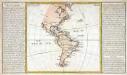
Isles, caps et ports de mer de l'Amerique
1 Karte : Kupferdruck ; 30 x 33 cm, Blattgrösse 32 x 55 cm Clouet Mondhare
Recentissima novi orbis sive Americae septentrionalis et meridionalis tabula
1 : 30000000 1 Karte : Kupferdruck ; 48 x 56 cm Danckerts, Justus [Danckerts]
America
1 : 25370000 Amerika Kiepert, Heinrich Gräf, Carl Geographisches Institut
Amérique ou Indes occidentales
1 Karte : Kupferdruck ; 52 x 49 cm, Gesamtgrösse 54 x 64 cm Delamarche Delamarche rue du Foin St. Jacques au collège de M.e Gervais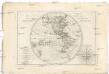
Mappe-monde sur le plan d'un méridien
Jižní Amerika André
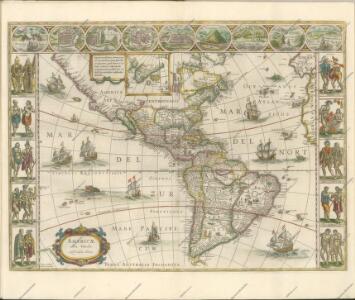
AMERICAE Aucta DELINEATIO
Amerika
Západnj polokaule
Amerika Merklas, Václav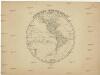
Západnj polokaule
Amerika Merklas, Václav
Západnj polokaule
Amerika Merklas, Václav
Západnj polokaule
Amerika Pluth Merklas, Václav
Školní nástěnná mappa [sic] Ameriky
1 : 10000000 Amerika Haardt von Hartenthurn, Vinzenz von Jireček, Josef Ed. Hölzel
Carte von America
1 : 31000000 Amerika Johannes Walch
Carte von America
1 : 31000000 Amerika Johannes Walch