Maps of South America

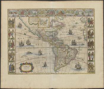
AMERICÆ | nova Tabula
Auct: Guiljelmo Blaeuw [Amsterdam : Joan Blaeu]
America septentrionalis novissima
1 : 37000000 [Amstelodami] : P. Schenk ex.
Carte d'Amerique
1 Karte : Kupferdruck ; 51 x 72 cm Nolin; Mondhare; Jean chez Monhare et Jean rue St. Jean de Beauvais
Amerika Historisch, Physisch und Politisch vom Jahr 1828
Historisch-genealogisch-geographischer Atlas von Le Sage Las Cases, Emmanuel Auguste Dieudonné Marius Joseph de Johann Velten, Kunsthändler
Novus orbis sive America meridionalis et septentrionalis
Amerika Seutter, Matthäus Probst, Johann Michael bey Iohan[n] Michael Probst
Novus orbis sive America meridionalis et septentrionalis
1 : 40000000 Amerika Seutter, Matthäus M. Seutter
A new general map of America
1 Karte : Kupferdruck ; 35 x 42 cm Bowen s.n.
Novi orbis sive totius Americæ cum adiacentibus insulis
1 Karte : Kupferdruck ; 27 x 33 cm Weigel Christoph Weigel
Novissima et accuratissima totius Americæ descriptio
1 Karte : Kupferdruck ; 42 x 53 cm Visscher Nicolaes Visscher
Amérique ou Nouveau Continent
1 Karte : Kupferdruck ; 46 x 52 cm, Gesamtgrösse 47 x 67 cm Nolin; Basset; Denis; Basset chès Basset rüe St. Jacques
Americæ tam septentrionalis quam meridionalis in mappa geographica delineatio
1 Karte : Kupferdruck ; 49 x 57 cm Zürner; Schenk ex officina Petri Schenkii in platea vulgo de Warmoes straat sub signo N. Visschers athlas
Homannův atlas světa
1 : 11500000
Mer des Indes.
1 : 70000000 Buache, Philippe, 1700-1773
America 1841 mit Benutzung der neuesten Vermessungen
1 : 37600000 Amerika Arrowsmith, David K. Geographischen Anstalt des Bibliographischen Instituts
America
Hand-Atlas über alle Theile der Erde nach dem neuesten Zustande und über das Weltgebäude Stieler, Adolf bei Justus Perthes
L'Amerique
1 Karte : Kupferdruck ; 48 x 62 cm Charlevoix; Le Rouge; La Condamine chez Le Rouge rue des gr.s Augustins
L'Amerique
1 Karte : Kupferdruck ; 48 x 62 cm Charlevoix; Crépy; La Condamine; Crépy chez Crepy rue S. Jacque à S. Pierre près la rue de la parcheminerie
America
Hand-Atlas über alle Theile der Erde nach dem neuesten Zustande und über das Weltgebäude Stieler, Adolf bei Justus Perthes
Carte d'Amerique
Amerika Delisle, Guillaume Condet, Johannes Covens & Mortier & Covens junior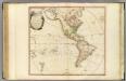
America.
1 : 42000000 Faden, William, 1750?-1836
Americae tam septentrionalis quam meridionalis in mappa geographica delineatio
1 : 30000000 ad mentem novissimorum eorumq. optimorum geographorum emendata indicibus utilissimis aucta et ad usum Tyronum imprimis geographicorum variis compendiosae methodi adminiculis accomodata opera A.F. Zürneri [...] [Amstelodami] : ex officina Petri Schenkii, in Platea vulgo de Warmoes straat sub signo N. Visschers athlas
America
Hand-Atlas über alle Theile der Erde und über das Weltgebäude Stieler, Adolf Justus Perthes
Novissima et Accuratissima Totius Americae Descriptio [Karte], in: Novus atlas absolutissimus, Bd. 6, S. 194.
1 Karte aus Atlas Janssonius Offizin
Amérique ou Indes occidentales
1 Karte : Kupferdruck ; 49 x 51 cm, Gesamtgrösse 50 x 65 cm Robert de Vaugondy; Delahaye; Fortin; Arrivet chés Fortin ing.r mécanicien du roy pour les globes et sphères rue de la Harpe près la rue du Foin
Carte d'Amerique
1 Karte : Kupferdruck ; 45 x 61 cm Clouet s.n.
America
1 : 25000000 Amerika Schmidt, Johann Marius Friedrich Franz Simon Schropp
America
1 : 29000000 Amerika Weiland, Karl Ferdinand Geographisches Institut
Amerika
Allgemeiner Atlas [Walch, Johannes] im Verlag bei Johannes Walch
Novus orbis sive America meridionalis et septentrionalis
1 Karte : Kupferdruck ; 48 x 55 cm Seutter; Probst anjezo in Verlag bey Iohann Michael Probst chalcogr