Maps of Asia

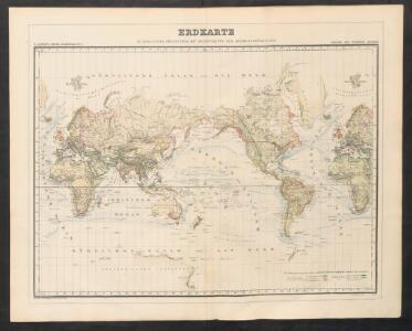
Erdkarte
Neuer Handatlas über alle Theile der Erde Kiepert, Heinrich Verlag von Dietrich Reimer
[System der Isotherm-Kurven]
Erster Band, enthaltend in vier Abtheilungen die Erscheinungen der anorganischen Natur: 1. Meteorologie und Klimatographie. 2. Hydrologie und Hydrographie. 3. Geologie. 4. Tellurischer Magnetismus Humboldt, Alexander von Verlag von Justus Perthes
Welt-Karte in Mercators Projektion
Grosser Hand-Atlas über alle Theile der Erde in 170 Karten Meyer, J. Verlag des Bibliographischen Instituts
Atlas über die Entwicklung von Industrie und Handel der Schweiz in dem Zeitraume vom Jahr 1770 bis zum Jahr 1870
1 : 45000000 1 Atlas ([3], VIII Bl.) im Auftrage der schweizerischen Commission für die additionellen Ausstellungen in Wien, bearbeitet von Dr. Hermann Wartmann Wurster Randegger & Co., Winterthur
Planiglob in Mercators Projection, zur Uebersicht der Erdfläche und der Seereisen
Hand-Atlas über alle Theile der Erde nach dem neuesten Zustande und über das Weltgebäude Stieler, Adolf bei Justus Perthes
Hyetographic or Rain Map of the World
The physical atlas Johnston, Alexander Keith William Blackwood & Sons
[Planiglob zur Übersicht der Verbreitung der Deutschen in beiden Hemisphären über den ganzen Erdboden]
Zweiter Band, enthaltend in vier Abtheilungen die Vertheilung der Organismen: 5. Pflanzen-Geographie, 6. Thier-Geographie, 7. Anthropographie, 8. Ethnographie Humboldt, Alexander von Verlag von Justus Perthes
Atlas über die Entwicklung von Industrie und Handel der Schweiz in dem Zeitraume vom Jahr 1770 bis zum Jahr 1870
1 : 45000000 1 Atlas ([3], VIII Bl.) im Auftrage der schweizerischen Commission für die additionellen Ausstellungen in Wien, bearbeitet von Dr. Hermann Wartmann Wurster Randegger & Co., Winterthur
[Erdkarte in Mercator's Projection, Vertheilung der Menschenracen und Verbreitungsgebiet einiger Hauptnährpflanzen]
Volksschul-Atlas über alle Teile der Erde Lange, Henry Druck und Verlag von Georg Westermann
W., E. Hemispheres.
1 : 64000000 Society for the Diffusion of Useful Knowledge (Great Britain)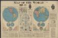
Map of the world
1 : 65000000 Rand McNally and Company Rand McNally and Company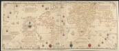
Carta universal en que se contiene todo lo que del mundo se ha descubierto fasta agora
1 : 30000000 Ribero, Diego Griggs, William
Middleton's pioneer map of the world, [as a?] plane and immoveable
Judd & Co.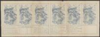
Nova Totius Terrarum Orbis Geographica Ac Hydrographica Tabula [Karte], in: Le théâtre du monde, ou, Nouvel atlas contenant les chartes et descriptions de tous les païs de la terre, Bd. 1, S. 26.
1 Karte aus Atlas Blaeu, Willem Janszoon und Blaeu, Joan Blaeu, Willem Janszoon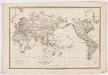
Allgemeine Weltkarte auf welcher alle neue Entdeckungen eines Pérouse, Wilson, Vancouver, Mungo-Park, Brown etc. dargestellt sind : nach Marcators Projection undden zuverlässigsten Astronomishcen Bestimungen entworsen
Simon Schropp'sche Hof-Landkartenhandlung bei Simon Schropp et Comp.
NOVA ET ACCVRATISSIMA TOTIVS TERRARVM ORBIS TABVLA
Auctore IOANNE BLAEV [Amsterdam : Joan Blaeu]
Welt-Karte, Globular-Proj.
1 : 150000000 Radefeld, Carl Christian Franz, 1788-1874
Planiglob zur Ubersicht der Verbreitung der Indo-Germanen .
1 : 140000000 Berghaus, Heinrich
Welt-Karte, Mercators Proj.
1 : 125000000 Radefeld, Carl Christian Franz, 1788-1874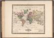
World on Mercators Projection.
1 : 80000000 Tanner, Henry S.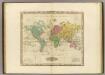
The World On Mercators Projection.
1 : 80000000 Tanner, Henry S.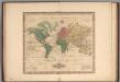
World on Mercators Projection.
1 : 80000000 Tanner, Henry S.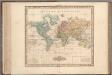
World on Mercators Projection.
1 : 80000000 Tanner, Henry S.
World on Mercators Projection.
1 : 80000000 Tanner, Henry S.
Hydrographical chart of the World.
1 : 82000000 Thomson, John
Humboldt's System of Isothermal Lines
The physical atlas Johnston, Alexander Keith William Blackwood & Sons
Typus Orbis Universalis [Karte], in: Geographia universalis vetus et nova complectens Claudii Ptolemaei Alexandrini enarrationis libros VIII, S. 216.
1 Karte aus Atlas Münster, Sebastian [und Ptolemaeus, Claudius]
[Planiglob in Mercators Projection, zur Uebersicht der Erdfläche und der Seereisen]
Stieler's Hand-Atlas Stieler, Adolf bei Justus Perthes
Atlas über die Entwicklung von Industrie und Handel der Schweiz in dem Zeitraume vom Jahr 1770 bis zum Jahr 1870
1 : 45000000 1 Atlas ([3], VIII Bl.) im Auftrage der schweizerischen Commission für die additionellen Ausstellungen in Wien, bearbeitet von Dr. Hermann Wartmann Wurster Randegger & Co., Winterthur