Maps of Asia

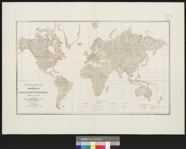
Atlas über die Entwicklung von Industrie und Handel der Schweiz in dem Zeitraume vom Jahr 1770 bis zum Jahr 1870
1 : 45000000 1 Atlas ([3], VIII Bl.) im Auftrage der schweizerischen Commission für die additionellen Ausstellungen in Wien, bearbeitet von Dr. Hermann Wartmann Wurster Randegger & Co., Winterthur
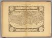
[1] Nova orbis tabula, uit: Atlas sive Descriptio terrarum orbis
Annotatie: Gedigitaliseerde versie. Amsterdam. Heiloo : Picturae (vervaardiger), 2015. tiff-bestand. Gedigitaliseerd: 07-01-2015; Origineel: Universiteitsbibliotheek Vrije Universiteit (XL.05127.-) ; Netherlands; Titelpagina ontbreekt Wit, Frederik de Amsterdam : Frederick de Wit
Nova Totius Terrarum Orbis Geographica Ac Hydrographica Tabula [Karte], in: Le théâtre du monde, ou, Nouvel atlas contenant les chartes et descriptions de tous les païs de la terre, Bd. 1, S. 26.
1 Karte aus Atlas Blaeu, Willem Janszoon und Blaeu, Joan Blaeu, Willem Janszoon
[Planiglob in Mercators Projection, zur Uebersicht der Erdfläche und der Seereisen]
Stieler's Hand-Atlas Stieler, Adolf bei Justus Perthes
Typus Orbis Universalis [Karte], in: Claud. Ptolemaeus. Geographia lat. cum mappis [...], S. 248.
1 Karte aus Atlas Münster, Sebastian [und Ptolemaeus, Claudius]
Orbis Terrarum Nova Et Accuratissima Tabula. [Karte], in: Novus atlas absolutissimus, Bd. 1, S. 17.
1 Karte aus Atlas Janssonius Offizin
Typus Orbis Universalis [Karte], in: Geographia universalis vetus et nova complectens Claudii Ptolemaei Alexandrini enarrationis libros VIII, S. 216.
1 Karte aus Atlas Münster, Sebastian [und Ptolemaeus, Claudius]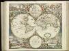
[121][124] Nova totius terrarum orbis tabula, uit: Atlas sive Descriptio terrarum orbis
Annotatie: Gedigitaliseerde versie. Amsterdam. Heiloo : Picturae (vervaardiger), 2015. tiff-bestand. Gedigitaliseerd: 07-01-2015; Origineel: Universiteitsbibliotheek Vrije Universiteit (XL.05127.-) ; Netherlands; Titelpagina ontbreekt Wit, Frederik de Amsterdam : Frederick de Wit
Planiglob zur Übersicht der Verbreitung der Indo-Germanen und Semiten über die gesammte Erdfläche
Zweiter Band, enthaltend in vier Abtheilungen die Vertheilung der Organismen: 5. Pflanzen-Geographie, 6. Thier-Geographie, 7. Anthropographie, 8. Ethnographie Humboldt, Alexander von Verlag von Justus Perthes
World.
1 : 110000000 Lavoisne, M.
Mappemonde.
Levasseur, E.
Western Hemisphere.
1 : 123000000 Lucas, Fielding Jr.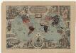
Missions-Weltkarte / lith. von E. Kaufmann
1 : 80000000 Annotatie geografische gegevens: Twee halfronden; Allegorische voorstellingen van de werelddelen rond het kaartbeeld; Legenda: evangelische, rooms-katholieke, grieks-katholieke en mohammedaanse verspreidingsgebieden E. Kaufmann Basel : Verlag der Missionsbuchhandlung
Western Hemisphere. Eastern Hemisphere.
1 : 60000000 Colton, G. Woolworth
[Erdkarte in Mercator's Projection, Vertheilung der Menschenracen und Verbreitungsgebiet einiger Hauptnährpflanzen]
Volksschul-Atlas über alle Teile der Erde Lange, Henry Druck und Verlag von Georg Westermann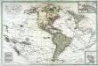
Carte de l'Amerique septentrionale et méridionale
1 Karte auf 2 Blatt : Kupferdruck ; 50 x 75 cm Lotter; Lotter Lotter
Principal Mountains, Plateaus, & Plains of The World.
1 : 100000000 Johnson, A.J.
Planisphaerium terrestre cum utroque coelesti hemisphaerio, sive diversa orbis terraquei ... / opera et studio A.F. Zürneri = Vlakke Aard-kloot met het beide hemelsch half-rond, of de onderscheidene verbeelding van de land-water-waereld ... / door vlyt en naarstigheid van A.F. Zürner
1 : 74000000 titelvariant: Vlakke Aard-kloot met het beide hemelsch half-rond, of de onderscheidene verbeelding van de land-water-waereld ...; Annotatie: Wereldkaart in twee halfronden (doorsnee 29 cm), hemelkaart in twee halfronden (doorsnee 14 cm), 6 bijkaarten (azimutale projecties vanuit verschillende raakvlakken) en andere genummerde afbeeldingen Adam Friedrich Zürner 1680-1742 [Amsterdam : Ex officina Petri Schenkii]
Facsimile: World by Mercator.
Mercator, Gerardus
Mappemonde en deux Hemispheres.
Levasseur, E.
Planisphere sur la Projection de Mercator.
Levasseur, E.
1-2. World, Physical. The World Atlas.
1 : 50000000 USSR (Union of Soviet Socialist Republics).
North America, South America, Asia, and Africa showing Minerals and Agriculture (Crops).
Hammond, C.S.
Map Of The World.
1 : 20000000 Walker, J. & C.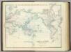
World on Mercators Projection.
1 : 72000000 Johnston, Alexander Keith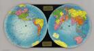
The Global Map.
1 : 50000000 Global Map Company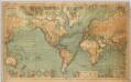
World On Mercator's Projection
1 : 15000000 Berghaus, Hermann