Maps of Lower Saxony

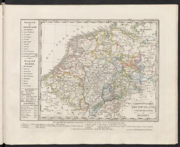
Nordwestliches Deutschland, Niederlande und Belgien
Schul-Atlas über alle Theile der Erde nach dem neuesten Zustande, und über das Weltgebäude Stieler, Adolf Justus Perthes
Nordwestliches Deutschland, Niederlande und Belgien
Schul-Atlas über alle Theile der Erde nach dem neuesten Zustande, und über das Weltgebäude Stieler, Adolf bei Justus Perthes
Nordwestliches Deutschland, Niederlande und Belgien

Nord-Westliches Deutschland, Niederlande Und Belgien.
1 : 1850000 Vogel, C.
NW Deutschland, Niederlande, Belgien.
1 : 5500000 Brudin, J. L.; Stieler, Adolf
Nord-Westliches Deutschland, Niederlande und Belgien
Handatlas über alle Theile der Erde und über das Weltgebäude Stieler, Adolf Justus Perthes
Nord-Westliches Deutschland, Niederlande und Belgien
Hand-Atlas über alle Theile der Erde und über das Weltgebäude Stieler, Adolf Justus Perthes
Nordwestliches Deutschland, Niederlande und Belgien
1 : 3441000 Belgie Justus Perthes
[Nordwestliches Deutschland, Kgr. der Niederlande, Kgr. Belgien]
Hand-Atlas über alle Theile der Erde nach dem neuesten Zustande und über das Weltgebäude Stieler, Adolf bei Justus Perthes
[Nordwestliches Deutschland und Kgr. Der Niederlande]
Stieler's Hand-Atlas Stieler, Adolf bei Justus Perthes
[Nordwestliches Deutschland, Kgr. Der Niederlande, Kgr. Belgien]
Hand-Atlas über alle Theile der Erde nach dem neuesten Zustande und über das Weltgebäude Stieler, Adolf bei Justus Perthes
Royaume des Pays-Bas. Europe 13.
1 : 1641836 Vandermaelen, Philippe, 1795-1869
Kaart van de Nederlandsche Noorder- en Zuider spoorwegen
1 : 2000000 [S.l.] : [s.n.]
Possessions du roi de Prusse a l'ouest du Weser
1 : 1730000 Neuchâtel (Švýcarsko) Mentelle, Edme Tardieu, Pierre François
Grossdeutsches Reich und angrenzende Gebiete

Galliæ antiquæ descriptio geographica, 2
1 Blatt : 44 x 57 cm s.n.
Tabula generalis totius Belgii
1 : 1000000 Belgie Homann, Johann Baptist á Iohanne Baptista Homanno
TABULA GENERALIS TOTIUS BELGII qua PROVINCIAE XVII. INFER. GERMANIAE olim sub S.R.I. CIRCULO BURGUNDIAE
1 : 1100000 Belgie Homann, Johann Baptist â Iohanne Baptista Homanno
Tabula generalis totius Belgii
1 : 1000000 Belgie Homann, Johann Baptist á Iohanne Baptista Homanno
Tabula generalis totius Belgii
1 : 1000000 Belgie Homann, Johann Baptist â Iohanne Baptista Homanno
Nouvelle carte geographique des postes des Pais Bas, de la Westphalie, & des provinces limitrophes
1 : 1
Die Herzogthuemer Saxonia und Lotharingia inferior; dann Thuringia, Osterland, Massia &c.
1 : 1900000 Spruner von Merz, Karl
Charte von dem Schiefer Gebirge des nordwestlichen Deutschlands Belgiens und des nordöstlichen Frankreichs
1 : 1150000 Ardeny Raumer, Carl von Guimpel, F.
Atlas für Handel und Industrie: Für Kaufleute, Fabrikante u. Gewerbetreibende, Handlungs- u. Gewerbe-Schulen

Nouvelle Carte du Royaume des Pays - Bas et Pays Limithropes...

Postkarte von dem Westphaelischen und Burgundischen Kreise
Burgundsko (Francie) Kühn, Ignaz im von Reilly'schen Landkarten und Kunstwerke Verschleiss Komptoir
Rheinprovinz, Westphalen, Holland und Belgien
Schul-Atlas in 36 Karten Völter, Daniel Verlag der J.M. Dannheimer'schen Buchhandlung
Westfront
1 : 1100000 [S.l. : s.n.]