Maps of okres Ústí nad Labem

Eisenbahn Karte Wien-Dresden, Ollmütz-Trübau
1 : 72000 Blatt 15 Minarzik, Anselm J. Rauh
Soubor přehledných map pro plánování a statistiku: 3752 – Litoměřice

Ústí n. L. a Litoměřice
1 : 75000 Benešov nad Ploučnicí (Česko : oblast) Vojenský zeměpisný ústav
Aussig und Leitmeritz
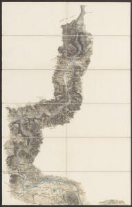
1 : 75000 Litoměřice (Česko : oblast) Acham, Stefan K. u. k. militär-geographisches Institut
Aussig und Leitmeritz
1 : 75000 Litoměřice (Česko : oblast) Acham, Stefan K. u. k. Militärgeographisches Institut
Aussig und Leitmeritz
1 : 75000 Litoměřice (Česko : oblast) K. u. k. Militärgeographisches Institut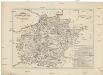
Charte der Bezirkshauptmannschaft Tetschen
1 : 80000 Děčín-oblast (Česko) Medau, Karel Vilém von dem Lehrpersonale der Leitmeritzer k.k. Hauptschule
[Geologická mapa Děčínska]
Děčín-oblast (Česko) Benecke
Übersichts Karte des Bezirkes Tetschen
1 : 56000 Děčín-oblast (Česko) Benecke Bormann, E.
Übersichts Karte des Bezirkes Tetschen
1 : 56000 Děčín-oblast (Česko) Bormann, E.
Übersichts Karte des Bezirkes Tetschen
Děčín-oblast (Česko) Kořistka, Karel František Edvard Kořistka, Karel František Edvard
Übersichts Karte des Bezirkes Tetschen
Děčín-oblast (Česko) Benecke Bormann, E.
Karte von dem Bezirk Tetschen
1 : 36000 Děčín-oblast (Česko) Bormann, E. Böhmische Forstverein
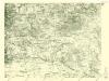
Litoměřice
1 : 75000 Litoměřice-oblast (Česko) Vojenský zeměpisný ústav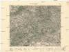
Litoměřice
1 : 75000 Litoměřice (Česko : oblast) Vojenský zeměpisný ústav
Soubor přehledných map pro plánování a statistiku: 3752 – Litoměřice

III. vojenské mapování 3752
1 : 75000
Bezirk Aussig
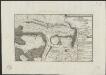
Plan de la battaille de Lobeschüz entre l'Armée Autrichienne et Prussienne sous les ordres de S. M. le Roi de Prusse et le Comte de Broune arrivée le 1. Octob. 1756
desin. par un volontair = entworfen in d. Armee v. einem Volontair [Leipzig] : [s.n.]
Karte des Bezirkes Tetschen
Děčín-oblast (Česko) F. Sandtner
Touristen-Karte des Aussiger Mittel- und Erzgebirgs-Vereines
1 : 75000 Krušné hory (Česko a Německo) Kroitzsch, Carl Mittel- und Erzgebirgesverein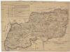
Karte der Bezirkshauptmannschaft zugleich Strafgerichtsbezirk Leitmeritz
1 : 222500 Litoměřice-oblast (Česko) von dem Lehrpersonale der Leitmeritzer k.k. Hauptschule
Bezirk Leitmeritz
1 : 36000 Litoměřice-oblast (Česko) Becker, H. H. Becker
Carte chorographique et militaire de la partie de la Saxe et de la Boheme...


III. vojenské mapování 3652/4
1 : 25000
[Kartenblatt]
1 : 25000 Děčín-oblast (Česko) Reichsamt für Landesaufnahme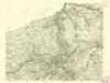
III. vojenské mapování 3652/4
1 : 25000
III. vojenské mapování 3752/2
1 : 25000