Maps of okres Ústí nad Labem

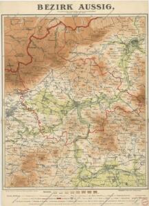
Bezirk Aussig

Landkreis Aussig
1 : 75000 Protektorát Čechy a Morava Dienststelle für Raumordnung und Landesplanung beim Regierungspräsidenten
Podrobná mapa Království českého
1 : 100000 Bílina (Česko : oblast) Srp, Jan Jaroslav Bursík
Wanderkarte fürs Elbetal und des angrenzenden Gebietes vom Mittel- und Erzgebirge
1 : 75000 Pirna (Německo) Kroitzsch, Carl vom Aussiger Gebirgsverein
Touristen-Karte des Aussiger Mittel- und Erzgebirgs-Vereines
1 : 75000 Krušné hory (Česko a Německo) Kroitzsch, Carl Mittel- und Erzgebirgesverein
Karte der Umgebung von Teplitz-Schönau
Teplice-oblast (Česko) August Copek
Aussig und Leitmeritz
1 : 75000 Litoměřice (Česko : oblast) Acham, Stefan K. u. k. militär-geographisches Institut
Aussig und Leitmeritz
1 : 75000 Litoměřice (Česko : oblast) Acham, Stefan K. u. k. Militärgeographisches Institut
Aussig und Leitmeritz
1 : 75000 Litoměřice (Česko : oblast) K. u. k. Militärgeographisches Institut
Soubor přehledných map pro plánování a statistiku: 3752 – Litoměřice

Ústí n. L. a Litoměřice
1 : 75000 Benešov nad Ploučnicí (Česko : oblast) Vojenský zeměpisný ústav
III. vojenské mapování 3752
1 : 75000
Karte der Teplitzer Umgebung und der Nachbarbezirke
1 : 143000 Teplice-oblast (Česko) C. Weigend
Soubor přehledných map pro plánování a statistiku: 3752 – Litoměřice

Litoměřice
1 : 75000 Litoměřice-oblast (Česko) Vojenský zeměpisný ústav
Litoměřice
1 : 75000 Litoměřice (Česko : oblast) Vojenský zeměpisný ústav
Umgebung der Badestadt Teplitz

Umgebungen der Badestadt Teplitz
1 : 110000 Teplice-oblast (Česko) Kreibich, František Jakub Jindřich C.W. Medau'sche Verlagsbuchhandlung
Umgebungen der Badestadt Teplitz
1 : 110000 Teplice-oblast (Česko) Kreibich, František Jakub Jindřich Albrecht, E. C.W. Medau'schen Buch- und Kunsthandlung
Plan de la battaille de Lobeschüz entre l'Armée Autrichienne et Prussienne sous les ordres de S. M. le Roi de Prusse et le Comte de Broune arrivée le 1. Octob. 1756
desin. par un volontair = entworfen in d. Armee v. einem Volontair [Leipzig] : [s.n.]

Carte chorographique et militaire de la partie de la Saxe et de la Boheme...

III. vojenské mapování 3752/3
1 : 25000
[Bitva u Chlumce a Přestanova]
Chlumec (Ústí nad Labem, Česko) Langweil, Antonín
Die Schlacht bei Kulm am 29. u. 30. August 1813
Chlumec (Ústí nad Labem, Česko) Loquens, Jos. Bormann, E.
Nollendorf-Kulm 30. August 1813
1 : 300000 Nakléřov Napoleonische Kriege , Schlacht
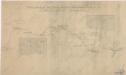
Die Herschaft Toeplitz im Lautmeritzer Creisse des Königreichs Boehmen
Uibersichtskarte der Aussig Teplitzer Eisenbahn und der in dieselbe einmündenden Zweigbahnen

Herrschaft Toeplitz im Leutmeritzer Creisse des Koenigreichs Böhmen
1 : 230000 Teplice-oblast (Česko)