Maps of Tovéř

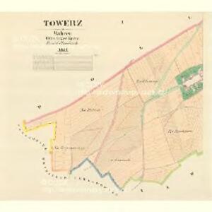
Towerz - m3123-1-001 - Kaiserpflichtexemplar der Landkarten des stabilen Katasters
1 : 2880
Towerz - m3123-1-002 - Kaiserpflichtexemplar der Landkarten des stabilen Katasters
1 : 2880
Samotische - m2692-1-002 - Kaiserpflichtexemplar der Landkarten des stabilen Katasters
1 : 2880
Samotische - m2692-1-001 - Kaiserpflichtexemplar der Landkarten des stabilen Katasters
1 : 2880
Samotische - m2692-1-003 - Kaiserpflichtexemplar der Landkarten des stabilen Katasters
1 : 2880
Drozdein - m0583-1-001 - Kaiserpflichtexemplar der Landkarten des stabilen Katasters
1 : 2880
Drozdein - m0583-1-004 - Kaiserpflichtexemplar der Landkarten des stabilen Katasters
1 : 2880
Drozdein - m0583-1-002 - Kaiserpflichtexemplar der Landkarten des stabilen Katasters
1 : 2880
Drozdein - m0583-1-003 - Kaiserpflichtexemplar der Landkarten des stabilen Katasters
1 : 2880
Drozdein - m0583-1-005 - Kaiserpflichtexemplar der Landkarten des stabilen Katasters
1 : 2880
Heiligberg - m1268-2-001 - Kaiserpflichtexemplar der Landkarten des stabilen Katasters
1 : 2880

Übersichtskarte der Gegend um Olmütz
Olomouc-oblast (Česko) Domek
Plan der königl. Hauptstadt Olmütz und Umgebung
1 : 2880 Olomouc-oblast (Česko) Schnizer, E. von Ed. Hölzel
Okolí olomucké
1 : 150000 Olomouc-oblast (Česko)
Olomouc a okolí
1 : 75000 Olomouc (Česko : oblast) Vojenský zeměpisný ústav
Podrobná místopisná mapa Království Českého

Podrobná mapa Markrabství moravského a Vévodství slezkého
1 : 100000 Libavá (Česko : oblast) Srp, Jan Jos. R. Vilímek
Karte der Umgebung von Olmütz
Olomouc-oblast (Česko) Lepař, Jan Raffelsperger, Franz
Podrobná mapa Království českého, Markrabství moravského a Vévodství slezského
1 : 100000 Libavá (Česko : oblast) Srp, Jan Jos. R. Vilímek
[Olomouc a okolí]
Prostějov-oblast (Česko) Lepař, Jan Raffelsperger, Franz
II. vojenské mapování 9
1 : 144000
Umgebungskarte von Olmütz
1 : 75000 Olomouc (Česko : oblast) K. u. k. Militärgeographisches Institut
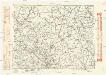
Mahrisch - Weisskirchen.
from Spezialkarte der osterreichisch-ungarischen Monarchie.
II. vojenské mapování 9
1 : 144000
Generální mapa okresních hejtmanství
Komunikační mapa země Moravskoslezské
1 : 100000 Olomouc (Česko : oblast) Morslez. zem. výbor
Marchionatûs Moraviae Circulus Olumucensis
1 : 233300 Mollova mapová sbírka Müller, Johann Christoph Homann, Johann Baptista - dědici
Circuli Preroviensis pars australis
1 : 150000 Morava (Česko) Müller, Johann Christoph