Maps of Olomouc

Karte der Umgebung von Olmütz
Olomouc-oblast (Česko) Lepař, Jan Raffelsperger, Franz
Umgebungskarte von Olmütz
1 : 75000 Olomouc (Česko : oblast) K. u. k. Militärgeographisches Institut
Okolí olomucké
1 : 150000 Olomouc-oblast (Česko)
Plan der königl. Hauptstadt Olmütz und Umgebung
1 : 2880 Olomouc-oblast (Česko) Schnizer, E. von Ed. Hölzel
Olomouc a okolí
1 : 75000 Olomouc (Česko : oblast) Vojenský zeměpisný ústav
[Olomouc a okolí]
Prostějov-oblast (Česko) Lepař, Jan Raffelsperger, Franz
Podrobná místopisná mapa Království Českého

Podrobná mapa Markrabství moravského a Vévodství slezkého
1 : 100000 Moravské markrabství Srp, Jan Jos. R. Vilímek
Podrobná místopisná mapa Království Českého

Übersichtskarte der Gegend um Olmütz
Olomouc-oblast (Česko) Domek
Plan zu den Gefechten bei Biskupitz 14. Juli Tobitschau und Roketnitz 15. Juli 1866
1 : 72000 Biskupice (Prostějov, Česko) Ditfurth, Moritz von des K. u. k. Militärgeographischen Instituts
Plan zu den Gefechten bei Biskupitz 14. Juli Tobitschau und Roketnitz 15. Juli 1866
1 : 72000 Biskupice (Prostějov, Česko)
Geologische Spezialkarte der... Österreichisch-Ungarischen Monarchie... Olmütz

Olmutz.; Spezialkarte der osterreichisch-ungarischen Monarchie.
from Spezialkarte der osterreichisch-ungarischen Monarchie. Austro-Hungarian Monarchy. Militärgeographisches Institut.,
Geologische Spezialkarte der im Reichsrate vertretenen Königreiche und Länder der Österreichisch-Ungarischen Monarchie
1 : 75000 Olomouc (Česko : oblast) Tietze, Emil Ernst August Lipold, Markus Vincenc K. k. geologischen Reichsanstalt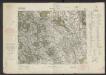
[Tschechoslowakie, Maßstab 1:75 000]. 4158, Olomouc : sonderausgabe : nur fur den dienstgebrauch
1 : 75000
Olomouc
1 : 75000 Morava (Česko) Vojenský zeměpisný ústav
Gradkartenblatt
1 : 25000 Morava (Česko) Duré, Friedrich
III. vojenské mapování 4158/4
1 : 25000
III. vojenské mapování 4158/4
1 : 25000
[Kartenblatt]
1 : 25000 Horka nad Moravou (Česko : oblast) Reichsamt für Landesaufnahme
III. vojenské mapování 4158/2
1 : 25000
III. vojenské mapování 4158/2
1 : 25000
Gradkartenblatt
1 : 25000 Morava (Česko) Duré, Friedrich


III. vojenské mapování 4159/1
1 : 25000
III. vojenské mapování 4159/3
1 : 25000
III. vojenské mapování 4159/1
1 : 25000


