Maps of Olomouc

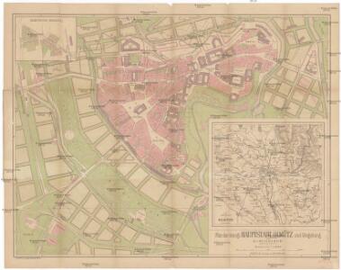
Plan der königl. Hauptstadt Olmütz und Umgebung
1 : 2880 Olomouc-oblast (Česko) Schnizer, E. von Ed. Hölzel
Okolí olomucké
1 : 150000 Olomouc-oblast (Česko)
Olomouc a okolí
1 : 75000 Olomouc (Česko : oblast) Vojenský zeměpisný ústav
Karte der Umgebung von Olmütz
Olomouc-oblast (Česko) Lepař, Jan Raffelsperger, Franz
Übersichtskarte der Gegend um Olmütz
Olomouc-oblast (Česko) Domek
Olmutz.; Spezialkarte der osterreichisch-ungarischen Monarchie.
from Spezialkarte der osterreichisch-ungarischen Monarchie. Austro-Hungarian Monarchy. Militärgeographisches Institut.,
Gradkartenblatt
1 : 25000 Morava (Česko) Duré, Friedrich
III. vojenské mapování 4158/4
1 : 25000
III. vojenské mapování 4158/4
1 : 25000

Bez Titulu: Okolí Olomouce


Gradkartenblatt
1 : 25000 Morava (Česko) Duré, Friedrich
[Kartenblatt]
1 : 25000 Horka nad Moravou (Česko : oblast) Reichsamt für Landesaufnahme

III. vojenské mapování 4158/2
1 : 25000
III. vojenské mapování 4158/2
1 : 25000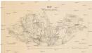
Plan des Gefechtsterrains bei Tobitschau
1 : 25000 Tovačov-oblast (Česko) Störmer Stachorowsky
III. vojenské mapování 4159/3
1 : 25000

Dollein (Dolan) - m0475-1-003 - Kaiserpflichtexemplar der Landkarten des stabilen Katasters
1 : 2880
Dollein (Dolan) - m0475-1-001 - Kaiserpflichtexemplar der Landkarten des stabilen Katasters
1 : 2880
Dollein (Dolan) - m0475-1-007 - Kaiserpflichtexemplar der Landkarten des stabilen Katasters
1 : 2880
Dollein (Dolan) - m0475-1-002 - Kaiserpflichtexemplar der Landkarten des stabilen Katasters
1 : 2880
Dollein (Dolan) - m0475-1-005 - Kaiserpflichtexemplar der Landkarten des stabilen Katasters
1 : 2880
Dollein (Dolan) - m0475-1-010 - Kaiserpflichtexemplar der Landkarten des stabilen Katasters
1 : 2880
Dollein (Dolan) - m0475-1-006 - Kaiserpflichtexemplar der Landkarten des stabilen Katasters
1 : 2880
Dollein (Dolan) - m0475-1-004 - Kaiserpflichtexemplar der Landkarten des stabilen Katasters
1 : 2880
Dollein (Dolan) - m0475-1-008 - Kaiserpflichtexemplar der Landkarten des stabilen Katasters
1 : 2880