Maps of Olomouc

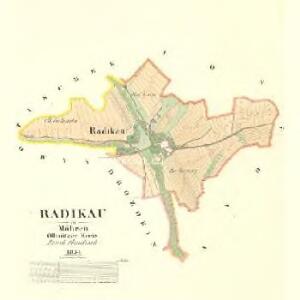
Radikau - m2507-1-001 - Kaiserpflichtexemplar der Landkarten des stabilen Katasters
1 : 2880
Loschau - m1607-1-003 - Kaiserpflichtexemplar der Landkarten des stabilen Katasters
1 : 2880
Loschau - m1607-1-005 - Kaiserpflichtexemplar der Landkarten des stabilen Katasters
1 : 2880
Loschau - m1607-1-007 - Kaiserpflichtexemplar der Landkarten des stabilen Katasters
1 : 2880
Loschau - m1607-1-001 - Kaiserpflichtexemplar der Landkarten des stabilen Katasters
1 : 2880
Loschau - m1607-1-006 - Kaiserpflichtexemplar der Landkarten des stabilen Katasters
1 : 2880
Loschau - m1607-1-002 - Kaiserpflichtexemplar der Landkarten des stabilen Katasters
1 : 2880
Loschau - m1607-1-004 - Kaiserpflichtexemplar der Landkarten des stabilen Katasters
1 : 2880

III. vojenské mapování 4159/1
1 : 25000
III. vojenské mapování 4159/1
1 : 25000
[Kartenblatt]
1 : 25000 Hlubočky (Česko : oblast) Reichsamt für Landesaufnahme
Übersichtskarte der Gegend um Olmütz
Olomouc-oblast (Česko) Domek
Hranice
1 : 75000 Hranice-oblast (Přerov, Česko) Vojenský zeměpisný ústav
Hranice
1 : 75000 Hranice (Přerov, Česko : oblast) Vojenský zeměpisný ústav
Hranice
1 : 75000 Hranice (Přerov, Česko : oblast) Vojenský zeměpisný ústav
Weisskirchen in Mähren
1 : 75000 Hranice (Přerov, Česko : oblast) Fitz K. u. k. Militärgeographisches Institut
Weisskirchen in Mähren
1 : 75000 Hranice (Přerov, Česko : oblast) Fitz K. u. k. Militärgeographisches Institut
Plan der königl. Hauptstadt Olmütz und Umgebung
1 : 2880 Olomouc-oblast (Česko) Schnizer, E. von Ed. Hölzel
III. vojenské mapování 4159
1 : 75000
Okolí olomucké
1 : 150000 Olomouc-oblast (Česko)
Olomouc a okolí
1 : 75000 Olomouc (Česko : oblast) Vojenský zeměpisný ústav
Podrobná místopisná mapa Království Českého

Podrobná mapa Markrabství moravského a Vévodství slezkého
1 : 100000 Libavá (Česko : oblast) Srp, Jan Jos. R. Vilímek
Karte der Umgebung von Olmütz
Olomouc-oblast (Česko) Lepař, Jan Raffelsperger, Franz
Podrobná mapa Království českého, Markrabství moravského a Vévodství slezského
1 : 100000 Libavá (Česko : oblast) Srp, Jan Jos. R. Vilímek
[Olomouc a okolí]
Prostějov-oblast (Česko) Lepař, Jan Raffelsperger, Franz
II. vojenské mapování 9
1 : 144000
Umgebungskarte von Olmütz
1 : 75000 Olomouc (Česko : oblast) K. u. k. Militärgeographisches Institut