Maps of Bečov nad Teplou

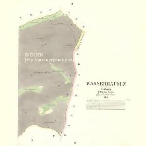
Wasserhäusln - c8717-2-002 - Kaiserpflichtexemplar der Landkarten des stabilen Katasters
1 : 2880
Wasserhäusln - c8717-2-001 - Kaiserpflichtexemplar der Landkarten des stabilen Katasters
1 : 2880
Müllersgrün - c4649-2-001 - Kaiserpflichtexemplar der Landkarten des stabilen Katasters
1 : 2880
Müllersgrün - c4649-2-002 - Kaiserpflichtexemplar der Landkarten des stabilen Katasters
1 : 2880
Gängerhof - c2553-2-006 - Kaiserpflichtexemplar der Landkarten des stabilen Katasters
1 : 2880
Gängerhof - c2553-2-001 - Kaiserpflichtexemplar der Landkarten des stabilen Katasters
1 : 2880
Gängerhof - c2553-2-002 - Kaiserpflichtexemplar der Landkarten des stabilen Katasters
1 : 2880
Gängerhof - c2553-2-007 - Kaiserpflichtexemplar der Landkarten des stabilen Katasters
1 : 2880
Gängerhof - c2553-2-005 - Kaiserpflichtexemplar der Landkarten des stabilen Katasters
1 : 2880
Gängerhof - c2553-2-003 - Kaiserpflichtexemplar der Landkarten des stabilen Katasters
1 : 2880
Gängerhof - c2553-2-004 - Kaiserpflichtexemplar der Landkarten des stabilen Katasters
1 : 2880
III. vojenské mapování 3950/3
1 : 25000
III. vojenské mapování 3950/3
1 : 25000
[Kartenblatt]
1 : 25000 Bezvěrov (Plzeň-sever, Česko : oblast) Reichsamt für Landesaufnahme
Gradkartenblatt
1 : 25000 Toužim-oblast (Česko) Böhm Karl


Lichtenstädter Vikariat
Hroznětín (Karlovy Vary, Česko)
Morphologische Uebersichtskarte des Falkenauer Tertiärbeckens
1 : 120000 Sokolov (Česko : oblast) Peter, Josef
Teusinger Vikariat
Toužim-oblast (Česko)
Marsch des k. frantzöischen Corpo, so Duc d'Mallabois com[m]andirt, wie weit selbiges in Böhmen avancirt A. 1742
1 : 247000 Cheb-oblast (Česko)
Karlsbad und Luditz
1 : 75000 Karlovy Vary (Česko : oblast) Höller, K. K. u. k. Militärgeographisches Institut
Karlsbad und Luditz
1 : 75000 Karlovy Vary (Česko : oblast) K. u. k. Militärgeographisches Institut
Karlovy Vary
1 : 75000 Bochov (Česko : oblast) Vojenský zeměpisný ústav
Karlovy Vary
1 : 75000 Karlovy Vary-oblast (Česko) Vojenský zeměpisný ústav
III. vojenské mapování 3950
1 : 75000
[Vilímkovy místopisné mapy zemí Koruny české]
1 : 100000 Karlovy Vary (Česko : oblast) Srp, Jan Jos. R. Vilímek
Eger und Falkenau.
from Spezialkarte der osterreichisch-ungarischen Monarchie.
Carlsbad mit dem Gantzen Ellenbogner Creisse im Königreiche Böhmen
1 : 360000 Mollova mapová sbírka Weigel, Christoph Weigel, Christoph I. - dědici