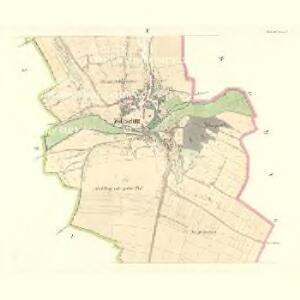
Maps of Hoštka

Welleschitz - c8365-1-002 - Kaiserpflichtexemplar der Landkarten des stabilen Katasters
1 : 2880
Welleschitz - c8365-1-001 - Kaiserpflichtexemplar der Landkarten des stabilen Katasters
1 : 2880
Welleschitz - c8365-1-003 - Kaiserpflichtexemplar der Landkarten des stabilen Katasters
1 : 2880
Gastorf - c2273-1-003 - Kaiserpflichtexemplar der Landkarten des stabilen Katasters
1 : 2880
Gastorf - c2273-1-004 - Kaiserpflichtexemplar der Landkarten des stabilen Katasters
1 : 2880
Gastorf - c2273-1-001 - Kaiserpflichtexemplar der Landkarten des stabilen Katasters
1 : 2880
Gastorf - c2273-1-005 - Kaiserpflichtexemplar der Landkarten des stabilen Katasters
1 : 2880
Gastorf - c2273-1-002 - Kaiserpflichtexemplar der Landkarten des stabilen Katasters
1 : 2880
Tschakowitz - c0788-1-001 - Kaiserpflichtexemplar der Landkarten des stabilen Katasters
1 : 2880
Tschakowitz - c0788-1-003 - Kaiserpflichtexemplar der Landkarten des stabilen Katasters
1 : 2880
Tschakowitz - c0788-1-002 - Kaiserpflichtexemplar der Landkarten des stabilen Katasters
1 : 2880
Molschen (Malessow) - c4415-1-005 - Kaiserpflichtexemplar der Landkarten des stabilen Katasters
1 : 2880
Molschen (Malessow) - c4415-1-001 - Kaiserpflichtexemplar der Landkarten des stabilen Katasters
1 : 2880
Molschen (Malessow) - c4415-1-004 - Kaiserpflichtexemplar der Landkarten des stabilen Katasters
1 : 2880
Molschen (Malessow) - c4415-1-002 - Kaiserpflichtexemplar der Landkarten des stabilen Katasters
1 : 2880
Molschen (Malessow) - c4415-1-003 - Kaiserpflichtexemplar der Landkarten des stabilen Katasters
1 : 2880
Schnedowitz - c7100-1-004 - Kaiserpflichtexemplar der Landkarten des stabilen Katasters
1 : 2880
Schnedowitz - c7100-1-001 - Kaiserpflichtexemplar der Landkarten des stabilen Katasters
1 : 2880
Schnedowitz - c7100-1-003 - Kaiserpflichtexemplar der Landkarten des stabilen Katasters
1 : 2880
Schnedowitz - c7100-1-002 - Kaiserpflichtexemplar der Landkarten des stabilen Katasters
1 : 2880
Půdní mapa okresu Roudnice nad Labem


Straßen-Karte des auton. Bezirkes Dauba
1 : 50000 Dubá (Česko : oblast)
Mapa okres. hejtmanství Roudnického
1 : 100000 Budyně nad Ohří-oblast (Česko) R. Kaška
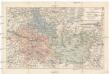
Karte der Bezirkshauptmannschaft zugleich Strafgerichtsbezirk Leitmeritz
1 : 222500 Litoměřice-oblast (Česko) von dem Lehrpersonale der Leitmeritzer k.k. Hauptschule
Litoměřice a okolí
1 : 75000 Litoměřice (Česko : oblast) Vojenský zeměpisný ústav
Okresní hejtmanství Roudnické
Roudnice nad Labem-oblast (Česko)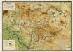
Wandkarte des politischen Bezirkes Dauba

Verbindungs-Dreiecke der Grundlinie zwischen dem Lorenz- und Georgenberge mit der trigonometrischen Vermessung der Gegend um Neuschloss
Petřín (Praha, Česko)