Maps of Průhonice

Augezd - c8237-1-002 - Kaiserpflichtexemplar der Landkarten des stabilen Katasters
1 : 2880
Augezd - c8237-1-003 - Kaiserpflichtexemplar der Landkarten des stabilen Katasters
1 : 2880
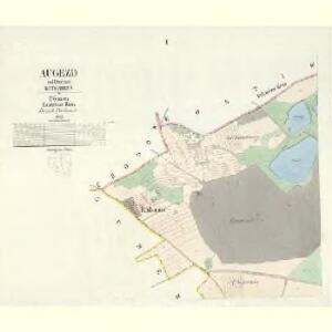
Augezd - c8237-1-001 - Kaiserpflichtexemplar der Landkarten des stabilen Katasters
1 : 2880
Výškopisný plán hlavního města Prahy s okolím

Mapa půd státních pokusných objektů zemědělských Průhonice
1 : 6000 Průhonice (Česko) Najmr, Stanislav Státní výzkumný ústav pro půdoznalství
Mapa půd státních pokusných objektů zemědělských Průhonice. Severní část území
Najmr, Stanislav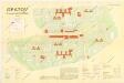
Jižní Město. - Opatov Orientační plán 2. souboru
1 : 2500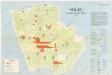
Jižní Město. - Háje Orientační plán 1. souboru
1 : 3500
Křeslitz - c3632-1-001 - Kaiserpflichtexemplar der Landkarten des stabilen Katasters
1 : 2880
Křeslitz - c3632-1-002 - Kaiserpflichtexemplar der Landkarten des stabilen Katasters
1 : 2880
Holle - c1955-1-001 - Kaiserpflichtexemplar der Landkarten des stabilen Katasters
1 : 2880
Holle - c1955-1-002 - Kaiserpflichtexemplar der Landkarten des stabilen Katasters
1 : 2880
Mapa katastrálních obcí
1 : 14400 Nusle (Praha, Česko) Herold, Theofil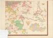
Orientierungsplan der Hauptstadt Prag
Jiřík, Rudolf
Scheberow - c7705-1-001 - Kaiserpflichtexemplar der Landkarten des stabilen Katasters
1 : 2880
Scheberow - c7705-1-002 - Kaiserpflichtexemplar der Landkarten des stabilen Katasters
1 : 2880
Scheberow - c7705-1-003 - Kaiserpflichtexemplar der Landkarten des stabilen Katasters
1 : 2880
Pruhonitz - c6147-1-002 - Kaiserpflichtexemplar der Landkarten des stabilen Katasters
1 : 2880
Pruhonitz - c6147-1-001 - Kaiserpflichtexemplar der Landkarten des stabilen Katasters
1 : 2880
Pruhonitz - c6147-1-003 - Kaiserpflichtexemplar der Landkarten des stabilen Katasters
1 : 2880
Mapa půd státních pokusných objektů zemědělských Průhonice. Jižní část území
Najmr, Stanislav
Hostiwarz (Hostiwarze) - c2250-1-004 - Kaiserpflichtexemplar der Landkarten des stabilen Katasters
1 : 2880
Hostiwarz (Hostiwarze) - c2250-1-005 - Kaiserpflichtexemplar der Landkarten des stabilen Katasters
1 : 2880
Hostiwarz (Hostiwarze) - c2250-1-003 - Kaiserpflichtexemplar der Landkarten des stabilen Katasters
1 : 2880
Hostiwarz (Hostiwarze) - c2250-1-006 - Kaiserpflichtexemplar der Landkarten des stabilen Katasters
1 : 2880
Hostiwarz (Hostiwarze) - c2250-1-001 - Kaiserpflichtexemplar der Landkarten des stabilen Katasters
1 : 2880
Hostiwarz (Hostiwarze) - c2250-1-002 - Kaiserpflichtexemplar der Landkarten des stabilen Katasters
1 : 2880
Orientační plán hlavního města Prahy s okolím

Orientační plán hlavního města Prahy s okolím
1 : 5000