Maps of Záryby

Polehrad - c5980-1-003 - Kaiserpflichtexemplar der Landkarten des stabilen Katasters
1 : 2880
Polehrad - c5980-1-002 - Kaiserpflichtexemplar der Landkarten des stabilen Katasters
1 : 2880
Polehrad - c5980-1-001 - Kaiserpflichtexemplar der Landkarten des stabilen Katasters
1 : 2880
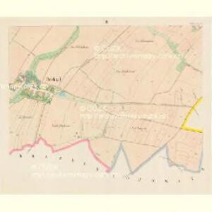
Alt-u G.-Brazdim (Stari a Welki Brazdim) - c0488-2-001 - Kaiserpflichtexemplar der Landkarten des stabilen Katasters
1 : 2880
Alt-u G.-Brazdim (Stari a Welki Brazdim) - c0488-2-002 - Kaiserpflichtexemplar der Landkarten des stabilen Katasters
1 : 2880
Alt-u G.-Brazdim (Stari a Welki Brazdim) - c0488-2-003 - Kaiserpflichtexemplar der Landkarten des stabilen Katasters
1 : 2880
Alt-u G.-Brazdim (Stari a Welki Brazdim) - c0488-2-004 - Kaiserpflichtexemplar der Landkarten des stabilen Katasters
1 : 2880
Elbekosteletz (Labsky-Kostelec) - c3375-1-005 - Kaiserpflichtexemplar der Landkarten des stabilen Katasters
1 : 2880
Elbekosteletz (Labsky-Kostelec) - c3375-1-004 - Kaiserpflichtexemplar der Landkarten des stabilen Katasters
1 : 2880
Elbekosteletz (Labsky-Kostelec) - c3375-1-002 - Kaiserpflichtexemplar der Landkarten des stabilen Katasters
1 : 2880
Elbekosteletz (Labsky-Kostelec) - c3375-1-001 - Kaiserpflichtexemplar der Landkarten des stabilen Katasters
1 : 2880
Elbekosteletz (Labsky-Kostelec) - c3375-1-003 - Kaiserpflichtexemplar der Landkarten des stabilen Katasters
1 : 2880
Popowitz - c6018-1-001 - Kaiserpflichtexemplar der Landkarten des stabilen Katasters
1 : 2880
Popowitz - c6018-1-003 - Kaiserpflichtexemplar der Landkarten des stabilen Katasters
1 : 2880
Popowitz - c6018-1-002 - Kaiserpflichtexemplar der Landkarten des stabilen Katasters
1 : 2880
[Brandeis mit seinen Umgebung]
Brandýs nad Labem-Stará Boleslav-oblast (Česko)
Gradkartenblatt
1 : 25000 Brandýs nad Labem-Stará Boleslav-oblast (Česko) Czechák, Carl

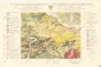
Mapa půd v okrese Brandýs n./Lab
1 : 38000 Brandýs nad Labem-Stará Boleslav-oblast (Česko) Spirhanzl, J. Srch, J. reprodukce Voj. zeměpisného ústavu
Karte des Brandeiser Bezirkes im Prager Kreise
1 : 70000 Brandýs nad Labem-Stará Boleslav-oblast (Česko) Wagner, Jan Eduard Karl André
Soubor map okresů Pražského kraje

Velká Praha a okolí

[Prag und Umgebung]
1 : 57600 Praha (Česko) Carl Bellmann's Verlag
Spezialkarte der Umgebung von Prag

Brandýský vikariát
Brandýs nad Labem-Stará Boleslav-oblast (Česko)
Prag Zone 5, Kol. 11
1 : 75000
III. vojenské mapování 3953
1 : 75000
Prag
1 : 75000 Praha (Česko : oblast) Fitz, J. K. u. k. Militärgeographisches Institut
Prag
1 : 75000 Praha (Česko : oblast) K. u. k. Militärgeographisches Institut