Maps of okres Karlovy Vary

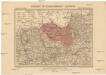
Ohorn - c2790-1-001 - Kaiserpflichtexemplar der Landkarten des stabilen Katasters
1 : 2880
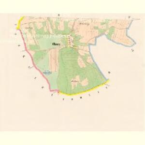
Ohorn - c2790-1-002 - Kaiserpflichtexemplar der Landkarten des stabilen Katasters
1 : 2880
Höfen - c2306-1-001 - Kaiserpflichtexemplar der Landkarten des stabilen Katasters
1 : 2880
Höfen - c2306-1-002 - Kaiserpflichtexemplar der Landkarten des stabilen Katasters
1 : 2880
Langgrün - c1128-2-001 - Kaiserpflichtexemplar der Landkarten des stabilen Katasters
1 : 2880
Langgrün - c1128-2-004 - Kaiserpflichtexemplar der Landkarten des stabilen Katasters
1 : 2880
Langgrün - c1128-2-003 - Kaiserpflichtexemplar der Landkarten des stabilen Katasters
1 : 2880
Langgrün - c1128-2-002 - Kaiserpflichtexemplar der Landkarten des stabilen Katasters
1 : 2880
Langgrün - c1128-2-006 - Kaiserpflichtexemplar der Landkarten des stabilen Katasters
1 : 2880
Langgrün - c1128-2-005 - Kaiserpflichtexemplar der Landkarten des stabilen Katasters
1 : 2880
Wohlau - c8315-1-002 - Kaiserpflichtexemplar der Landkarten des stabilen Katasters
1 : 2880
Wohlau - c8315-1-001 - Kaiserpflichtexemplar der Landkarten des stabilen Katasters
1 : 2880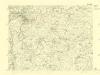
III. vojenské mapování 3950/1
1 : 25000

Gradkartenblatt
1 : 25000 Karlovy Vary-oblast (Česko) Böhm, Karl
Karlsbader Bezirkskarte
1 : 75000 Karlovy Vary-oblast (Česko) Kutschera, G. G. Kutschera
Luditzer Vikariat
Žlutice-oblast (Česko)
Karlsbad und Luditz
1 : 75000 Karlovy Vary (Česko : oblast) Höller, K. K. u. k. Militärgeographisches Institut
Karlsbad und Luditz
1 : 75000 Karlovy Vary (Česko : oblast) K. u. k. Militärgeographisches Institut
Karlovy Vary
1 : 75000 Bochov (Česko : oblast) Vojenský zeměpisný ústav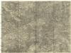
Ostrov u Karlových Varů a okolí
1 : 75000 Karlovy Vary (Česko : oblast) Vojenský zeměpisný ústav
Karlovy Vary
1 : 75000 Karlovy Vary-oblast (Česko) Vojenský zeměpisný ústav
III. vojenské mapování 3950
1 : 75000
[Vilímkovy místopisné mapy zemí Koruny české]
1 : 100000 Karlovy Vary (Česko : oblast) Srp, Jan Jos. R. Vilímek
Umgebungen von Lubenz
Lubenec-oblast (Česko) Kiss, Josef K. u. k. Militärgeographisches Institut
Kaaden und St. Joachimsthal.
from Spezialkarte der osterreichisch-ungarischen Monarchie.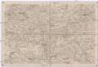
Umgebungen von Lubenz
1 : 750000 Lubenec (Česko : oblast) K. k. militär-geographisches Institut
Karlsbad und Luditz.
from Spezialkarte der osterreichisch-ungarischen Monarchie.
II. vojenské mapování 12
1 : 144000