Maps of Hřibojedy

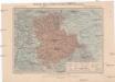
Stern - c2443-1-001 - Kaiserpflichtexemplar der Landkarten des stabilen Katasters
1 : 2880
Littitsch (Litiče) - c4159-1-004 - Kaiserpflichtexemplar der Landkarten des stabilen Katasters
1 : 2880
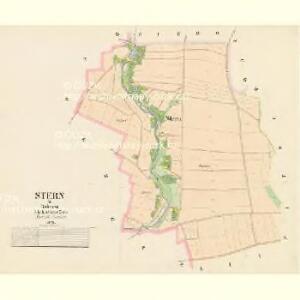
Littitsch (Litiče) - c4159-1-001 - Kaiserpflichtexemplar der Landkarten des stabilen Katasters
1 : 2880
Littitsch (Litiče) - c4159-1-003 - Kaiserpflichtexemplar der Landkarten des stabilen Katasters
1 : 2880
Littitsch (Litiče) - c4159-1-002 - Kaiserpflichtexemplar der Landkarten des stabilen Katasters
1 : 2880
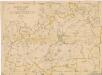
Siebojed (Řibojedy) - c2392-1-001 - Kaiserpflichtexemplar der Landkarten des stabilen Katasters
1 : 2880
Siebojed (Řibojedy) - c2392-1-003 - Kaiserpflichtexemplar der Landkarten des stabilen Katasters
1 : 2880
Siebojed (Řibojedy) - c2392-1-002 - Kaiserpflichtexemplar der Landkarten des stabilen Katasters
1 : 2880
Mapa politického a školního okresu Hradce Králové

Silniční mapa
1 : 25000
Karte des politischen Bezirkes Königinhof

Cís. král. komornj panstwj Hořeňowské a Smiřické s připojeným hraběcým Cerekwickým
1 : 200000 Cerekvice nad Bystřicí (Česko) Hanka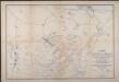
Karte des Schlachtfeldes von Königgrätz
1 : 50000 Gerold
Jičín
1 : 75000 Dvůr Králové nad Labem (Česko : oblast) Vojenský zeměpisný ústav
Operations-Karte für die Schlacht bei Königgrätz
1 : 100000 Hradec Králové-oblast (Česko)
Hořitz und Jičin
1 : 75000 Dvůr Králové nad Labem (Česko : oblast) Richter K. u. k. militär-geographisches Institut
Hořitz und Jičin
1 : 75000 Dvůr Králové nad Labem (Česko : oblast) Richter K. u. k. Militärgeographisches Institut
Hořitz und Jičin
1 : 75000 Hořice (Jičín, Česko : oblast) K. u. k. Militärgeographisches Institut
Mapa okresního hejtmanství Královedvorského

Josefov a okolí
1 : 75000 Jaroměř (Česko : oblast) Vojenský zeměpisný ústav
Podrobná mapa Království českého
1 : 100000 Dvůr Králové nad Labem (Česko : oblast) Srp, Jan Jaroslav Bursík
Graenze zwischen dem Koeniggraetzer vnd Bidschower Kreis
1 : 180000 Dvůr Králové nad Labem-oblast (Česko) Koch
Vilímkovy místopisné mapy zemí Koruny české
1 : 100000 Dvůr Králové nad Labem (Česko : oblast) Srp, Jan Jos. R. Vilímek
Mapa okresního hejtmanství Královédvorského
1 : 100000 Dvůr Králové nad Labem-oblast (Česko) Erben, Josef Flemming, C. nákladem Karla Janského
Mapa okresního hejtmanství Královéhradeckého
1 : 100000 Hradec Králové-oblast (Česko) Erben, Josef Flemming, C. nákladem Karla Janského
[Trautenau, Königinhof und Umgebung]
1 : 243000 Králův Dvůr (Česko)
Vilímkovy podrobné mapy politických okresů

Camp que l'armée de Sa Majesté l'imperatrice sous les ordres du prince Picolomini á occupe pour observer la retraite de l'armée prussienne sous le comandement du comte Swerin
1 : 110000 Hradec Králové-oblast (Česko)
Generální mapa okresního hejtmanství Nov. Města nad Metují
1 : 220000 Nové Město nad Metují-oblast (Česko) Wagner, Jan Eduard F. Kytka