Maps of Hradec Kralove

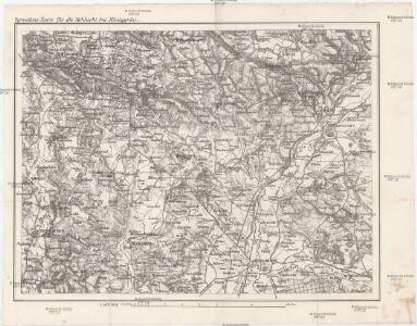
Operations-Karte für die Schlacht bei Königgrätz
1 : 100000 Hradec Králové-oblast (Česko)
Karte des Schlachtfeldes von Königgrätz
1 : 50000 Gerold
Mapa okresního hejtmanství Královéhradeckého
1 : 100000 Hradec Králové-oblast (Česko) Erben, Josef Flemming, C. nákladem Karla Janského
Cís. král. komornj panstwj Hořeňowské a Smiřické s připojeným hraběcým Cerekwickým
1 : 200000 Cerekvice nad Bystřicí (Česko) Hanka
Podrobná mapa Království českého
1 : 100000 Dvůr Králové nad Labem (Česko : oblast) Srp, Jan Jaroslav Bursík
Josefov a okolí
1 : 75000 Jaroměř (Česko : oblast) Vojenský zeměpisný ústav
Plan des Schachtfeldes von Königgrätz 3. Juli 1866
1 : 28880 Hradec Králové (Česko) Ditfurth, Moritz von des K. u. k. Militärgeographischen Instituts
Silniční mapa
1 : 25000
Die Schlacht von Königgrätz
1 : 200000 Hradec Králové (Česko : oblast) F.A. Brockhaus' geogr.-artist. Anstalt
Plan des Schlachtfeldes von Königgrätz
1 : 50000 Hradec Králové (Česko : oblast)
Plan des Schlachtfeldes von Königgrätz
1 : 50000
III. vojenské mapování 3855/4
1 : 25000
Gradkartenblatt
1 : 25000 Cerekvice nad Bystřicí-oblast (Česko) Böhm, Karl
[Kartenblatt]
1 : 25000 Cerekvice nad Bystřicí (Česko : oblast) Reichsamt für Landesaufnahme
Schlachtfeld von Königgrätz
1 : 200000 Hradec Králové (Region) Schlacht bei Königgrätz
[Gradkartenblatt]
1 : 25000 Hořice-oblast (Jičín, Česko) Vojenský zeměpisný ústav
Plan des Schlachtfeldes von Königsgrätz
1 : 25000 Kgl. Preussischer Generalstab

Übersichts-Karte der Reichsdomaine Smiřitz und Hořennowes
1 : 28000 Smiřice-oblast (Česko)


Bez titulu: Čechy – část

Gradkartenblatt
1 : 25000 Jaroměř-oblast (Česko) Böhm, Karl
[Kartenblatt]
1 : 25000 Jaroměř (Česko : oblast) Reichsamt für Landesaufnahme
Mapa politického a školního okresu Hradce Králové

III. vojenské mapování 3856/3
1 : 25000
III. vojenské mapování 3856/3
1 : 25000
Mapa politického a školního okresu Hradce Králové

Regni Bohemiae circulus Reginohradecensis
1 : 165000 Hradec Králové-oblast (Česko) Hauer, Daniel Adam ab Homannianis Heredibus
Regni Bohemiae Circulus Reginohradecensis
1 : 165000 Hradec Králové (Česko : oblast) Müller, Johann Christoph Hauer, Daniel Adam in lucem editus ab Homannianis Heredibus