Maps of okres Rychnov nad Kněžnou

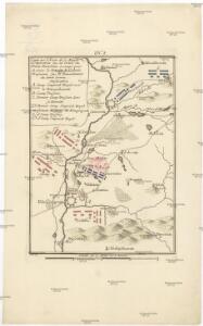
Camp que l'armée de Sa Majesté l'imperatrice sous les ordres du prince Picolomini á occupe pour observer la retraite de l'armée prussienne sous le comandement du comte Swerin
1 : 110000 Hradec Králové-oblast (Česko)
Generální mapa okresního hejtmanství Nov. Města nad Metují
1 : 220000 Nové Město nad Metují-oblast (Česko) Wagner, Jan Eduard F. Kytka
Generální mapa okresního hejtmanství Nov. Města nad Metují
1 : 220000 Nové Město nad Metují-oblast (Česko) Wagner, Jan Eduard F. Kytka
Josefstadt und Nachod.
from Spezialkarte der osterreichisch-ungarischen Monarchie.
Generální mapa okresních hejtmanství

Politický okres novoměstský
Nové Město nad Metují-oblast (Česko) Srp, Jan Luther, Th. Jos. R. Vilímek
Generální mapa okresních hejtmanství

Camp imperial royal comandé par le prince Picolomini et celui des Prussiennes comandé par le comte Swerin
Hradec Králové-oblast (Česko) Trattner, Johann Thomas Jean Thomas Trattner
Josefov a okolí
1 : 75000 Jaroměř (Česko : oblast) Vojenský zeměpisný ústav
Zone 4, Kol. XIV, Josefstadt und Nachod, uit: Geologische Karte der im Reichsrathe vertretenen Königreiche und Länder der Österreich-Ungarischen Monarchie : auf Grundlage der Specialkarte i.M. 1:75.000 des k.u.k. Militär-geographischen Institutes / neu bearb. und als Kartenwerk von 341 Blattnummern in zwanglosen Lfg. hrsg. durch die k.k. Geologische Reichsanstalt in Wien
1 : 75000 titelvariant: Geologische Spezialkarte der im Reichsrate vertretenen Königreiche und Länder der Österreichisch-Ungarischen Monarchie; Geologische Specialkarte der im Reichsrathe vertretenen Königreiche und Länder der Österreichisch-Ungarischen Monarchie; Annotatie: Titel bovenaan kaartblad: Geologische Spezialkarte der im Reichsrate vertretenen Königreiche und Länder der Österreichisch-Ungarischen Monarchie en Geologische Specialkarte der im Reichsrathe vertretenen Königreiche und Länder der Österreichisch-Ungarischen Monarchie; Annotatie geografische gegevens: Coördinaten gebaseerd op nulmeridiaan van Ferro (Hierro) Kaiserlich-Königliche Geologische Reichsanstalt, Wenen Wien : K.K. Geologische Reichsanstalt
Josefstadt und Nachod
1 : 75000 Dobruška (Česko : oblast) Neumann K. u. k. militär-geographisches Institut
Josefstadt und Nachod
1 : 75000 Dobruška (Česko : oblast) Neumann K. u. k. Militärgeographisches Institut
Josefstadt und Nachod
1 : 75000 Dobruška (Česko : oblast) Neumann K. u. k. Militärgeographisches Institut
Josefstadt und Nachod
1 : 75000 Jaroměř (Česko : oblast) K. u. k. Militärgeographisches Institut
Mapa okresního hejtmanství Novoměstského n/M
1 : 100000 Nové Město nad Metují-oblast (Česko) Erben, Josef nákladem Karla Janského
III. vojenské mapování 3856
1 : 75000

Náchod
1 : 75000 Náchod-oblast (Česko) Vojenský zeměpisný ústav
Josefov a Náchod
1 : 75000 Náchod (Česko : oblast) Vojenský zeměpisný ústav
Josefov a Náchod
1 : 75000 Dobruška (Česko : oblast) Vojenský zeměpisný ústav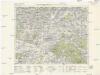
Königgrätz u. Umgebung
1 : 75000 Hradec Králové (Česko : oblast) Landesvermessungsamt Böhmen u. Mähren
Hradec Králové a okolí
1 : 75000 Hradec Králové (Česko : oblast) Vojenský zeměpisný ústav
Cís. král. komornj panstwj Hořeňowské a Smiřické s připojeným hraběcým Cerekwickým
1 : 200000 Cerekvice nad Bystřicí (Česko) Hanka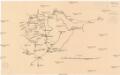
[Neustadt und Umgebung]
1 : 144000 Nové Město nad Metují (Česko : oblast)
Podrobná mapa Království českého
1 : 100000 Nové Město nad Metují (Česko : oblast) Srp, Jan Jaroslav Bursík
Mapa okresního hejtmanství Rychnovského

Mapa okresního hejtmanství Rychnovského

III. vojenské mapování 3956
1 : 75000
Reichenau und Tyništ
1 : 75000 Choceň (Česko : oblast) Fenzl K. u. k. militär-geographisches Institut
Reichenau und Tyništ
1 : 75000 Choceň (Česko : oblast) Fenzl K. u. k. Militärgeographisches Institut