Maps of Stráž

Dehenten - c1080-1-002 - Kaiserpflichtexemplar der Landkarten des stabilen Katasters
1 : 2880
Dehenten - c1080-1-001 - Kaiserpflichtexemplar der Landkarten des stabilen Katasters
1 : 2880
Dehenten - c1080-1-003 - Kaiserpflichtexemplar der Landkarten des stabilen Katasters
1 : 2880
Czernahora (Cernahora) - c0869-1-002 - Kaiserpflichtexemplar der Landkarten des stabilen Katasters
1 : 2880
Czernahora (Cernahora) - c0869-1-001 - Kaiserpflichtexemplar der Landkarten des stabilen Katasters
1 : 2880
Czernahora (Cernahora) - c0869-1-003 - Kaiserpflichtexemplar der Landkarten des stabilen Katasters
1 : 2880
Wabitz (Wabce) - c0041-1-001 - Kaiserpflichtexemplar der Landkarten des stabilen Katasters
1 : 2880
Wabitz (Wabce) - c0041-1-002 - Kaiserpflichtexemplar der Landkarten des stabilen Katasters
1 : 2880
Wurken - c0376-1-001 - Kaiserpflichtexemplar der Landkarten des stabilen Katasters
1 : 2880
Wurken - c0376-1-003 - Kaiserpflichtexemplar der Landkarten des stabilen Katasters
1 : 2880
Wurken - c0376-1-002 - Kaiserpflichtexemplar der Landkarten des stabilen Katasters
1 : 2880
Porostní mapa revíru Olešná
1 : 8640
Mapa pozemků dvora Borek
1 : 11520
Tuz - c1583-1-002 - Kaiserpflichtexemplar der Landkarten des stabilen Katasters
1 : 2880
Tuz - c1583-1-001 - Kaiserpflichtexemplar der Landkarten des stabilen Katasters
1 : 2880

Pfraumberg
1 : 75000 Poběžovice (Domažlice, Česko : oblast) Kimlein K. u. k. militär-geographisches Institut
Pfraumberg
1 : 75000 Poběžovice (Domažlice, Česko : oblast) Kimlein K. u. k. Militärgeographisches Institut
Pfraumberg
1 : 75000 Přimda-oblast (Česko) K. u. k. Militärgeographisches Institut
III. vojenské mapování 4149
1 : 75000
Politický okres Tachov
1 : 75000 Tachov (Česko : okres : 1960-) Vojenský zeměpisný ústav
Politický okres Tachov
Böhmerwald-Verbindungsbahn
1 : 75000 Domažlice-Planá u Mariánských Lázní (Česko : železniční trať) Technisches Bureau Ing. Max Picha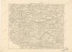
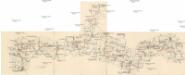
Podrobná místopisná mapa Království Českého

II. vojenské mapování 17
1 : 144000
Bischofteinitz und Nurschan.
from Spezialkarte der osterreichisch-ungarischen Monarchie.
Pfraumberg.
from Spezialkarte der osterreichisch-ungarischen Monarchie.
Umgebungen von Plan und Hayd

Umgebungen von Plan und Hayd
1 : 750000 Bor (Tachov, Česko : oblast) Kiss, Josef K. k. militär-geographisches Institut


