Maps of Bochov

Tschies - c1008-1-002 - Kaiserpflichtexemplar der Landkarten des stabilen Katasters
1 : 2880
Tschies - c1008-1-001 - Kaiserpflichtexemplar der Landkarten des stabilen Katasters
1 : 2880
Tschies - c1008-1-003 - Kaiserpflichtexemplar der Landkarten des stabilen Katasters
1 : 2880
Miroditz - c4702-1-001 - Kaiserpflichtexemplar der Landkarten des stabilen Katasters
1 : 2880
Miroditz - c4702-1-002 - Kaiserpflichtexemplar der Landkarten des stabilen Katasters
1 : 2880
Miroditz - c4702-1-003 - Kaiserpflichtexemplar der Landkarten des stabilen Katasters
1 : 2880
Miroditz - c4702-1-004 - Kaiserpflichtexemplar der Landkarten des stabilen Katasters
1 : 2880
Schwinau (Sswinow) - c7646-1-004 - Kaiserpflichtexemplar der Landkarten des stabilen Katasters
1 : 2880
Schwinau (Sswinow) - c7646-1-003 - Kaiserpflichtexemplar der Landkarten des stabilen Katasters
1 : 2880
Schwinau (Sswinow) - c7646-1-001 - Kaiserpflichtexemplar der Landkarten des stabilen Katasters
1 : 2880
Schwinau (Sswinow) - c7646-1-002 - Kaiserpflichtexemplar der Landkarten des stabilen Katasters
1 : 2880
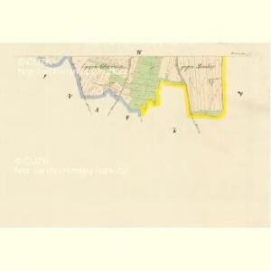
Deutsch Killmes - c5162-1-002 - Kaiserpflichtexemplar der Landkarten des stabilen Katasters
1 : 2880
Deutsch Killmes - c5162-1-003 - Kaiserpflichtexemplar der Landkarten des stabilen Katasters
1 : 2880
Deutsch Killmes - c5162-1-004 - Kaiserpflichtexemplar der Landkarten des stabilen Katasters
1 : 2880
Deutsch Killmes - c5162-1-001 - Kaiserpflichtexemplar der Landkarten des stabilen Katasters
1 : 2880
[Kartenblatt]
1 : 25000 Bochov (Česko : oblast) Reichsamt für Landesaufnahme

Gradkartenblatt
1 : 25000 Karlovy Vary-oblast (Česko) Böhm, Karl
Luditzer Vikariat
Žlutice-oblast (Česko)
Lichtenstädter Vikariat
Hroznětín (Karlovy Vary, Česko)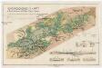
Montangeologische Karte der Braunkohlenreviere von Falkenau, Elbogen u. Karlsbad
1 : 50000 Karlovy Vary (Česko : oblast) Frieser, Antonín Adolf Becker
Montangeologische Karte der Braunkohlenreviere von Falkenau, Elbogen u[nd] Karlsbad
1 : 50000 Karlovy Vary (Česko : oblast) Frieser, Anton Adolf Becker
Karlsbad und Luditz
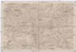
1 : 75000 Karlovy Vary (Česko : oblast) Höller, K. K. u. k. Militärgeographisches Institut
Karlsbad und Luditz
1 : 75000 Karlovy Vary (Česko : oblast) K. u. k. Militärgeographisches Institut
Karlovy Vary
1 : 75000 Bochov (Česko : oblast) Vojenský zeměpisný ústav
Karlovy Vary
1 : 75000 Karlovy Vary-oblast (Česko) Vojenský zeměpisný ústav
III. vojenské mapování 3950
1 : 75000
[Vilímkovy místopisné mapy zemí Koruny české]
1 : 100000 Karlovy Vary (Česko : oblast) Srp, Jan Jos. R. Vilímek
Umgebungen von Lubenz
Lubenec-oblast (Česko) Kiss, Josef K. u. k. Militärgeographisches Institut