Maps of Landkreis Emsland

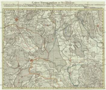
Carte topographique d'Allemagne
1 : 214500 Friesland (Německo) Jaeger, Johann Wilhelm Abraham I.W.A. Iaeger
1:250 000 Europe
1 : 250000 Osnabrück (Německo) War Office
Basse Partie De L'Evesché De Munster, Et Le Comté De Benthem. [Karte], in: Atlas nouveau, contenant toutes les parties du monde [...], Bd. 1, S. 307.
1 Karte aus Atlas Sanson, Nicolas Jaillot, Alexis Hubert und Mortier, Pieter
[8], uit: Hydro-Oro und Chorographische General Karte des Koenigreichs der Niederlande und der angrenzenden Länder bis Paris : mit der Angabe der Kunst und Heer-Strassen und der Entfernung der Poststationen / ... zusammengetragen und reducirt von ... Wilhelm Müller
1 : 400000 titelvariant: Generalkarte des Koenigreichs Hannover; Annotatie: 1e supplement bij: Generalkarte des Koenigreichs Hannover (1818) Müller, Wilhelm (fl. 1818) [Hannover : Wilhelm Müller]
Episcopatvs Monasteriensis Pars Septentrionalis
1 : 290000 Mollova mapová sbírka Gigas, Johann Michael
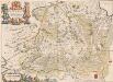
Episcopatvs Monasteriensis Pars Septentrionalis
1 : 290000 Mollova mapová sbírka Gigas, Johann Michael
Le Theatre de Bellone :
Mollova mapová sbírka Schenk, Pieter Braakman, Adriaan
L'Eveché de Munster Le Comté de Bentheim Tecklenbourg Stenford Lingen, Diepholtz Delmenhorst, Ritberg &c.
1 : 420000 Mollova mapová sbírka Le Rouge, Georges-Louis Le Rouge, Georges-Louis
Basse Partie de l'Evesché de Munster, et le Comté de Benthem
1 : 300000 Mollova mapová sbírka Sanson, Guillaume Mortier, Pierre
[Zuid-Groningen en Drente]
1 : 100000 [door H.J. Weits (?)]

Groningen 43, uit: Special-Karte von Mittel-Europa / nach amtlichen Quellen bearbeitet von W. Liebenow
1 : 300000 titelvariant: W. Liebenow's Mittel-Europa; Annotatie: Titel boven de bladen: W. Liebenow's Mittel-Europa Johannes Wilhelm Liebenow 1822-1897 Frankfurt a. M. : Ludwig Ravenstein
DOMINII GRONINGEN nec non maximae partis DRENTIAE
1 : 180000 Gröningen (Německo) Visscher, Nicolaus Hooghe, Romeyn de Nicolaus Visscher excud.
Kaart van Groningen en Drenthe
1 : 500000 volgens de nieuwste en naauwkeurigste stukken zamengesteld en in het koper gebragt door Dl. Veelwaard, Junior. Te Haarlem : bij de Erven F. Bohn
Groningen 43, uit: [W. Liebenow's Special-Karte von Mittel-Europa]
1 : 300000 titelvariant: W. Liebenow's Mittel-Europa; Annotatie: Titel boven de bladen: W. Liebenow's Mittel-Europa Johannes Wilhelm Liebenow 1822-1897 Hannover : Hermann Oppermann
Drentia comitatvs
Bouttats, Gaspar
Nova totius provinciae Groningo-Omlandiae in Belgio tabula
1 : 200000 Groningen (Nizozemsko) edentibus Homannianis Heredibus
Drenthe, uit: Sterfte-atlas van Nederland over 1860-1874 / [uitgave van de Nederlandsche Maatschappij tot Bevordering der Geneeskunst]
titelvariant: Sterfte-atlas van Nederland; Annotatie: Alleen kaartbijlage aanwezig Pieter Harmen Witkamp 1816-1892; Nederlandsche Maatschappij tot Bevordering der Geneeskunst Amsterdam : van Rossen
Drente, uit: [Provinciale fietskaart ...]
Annotatie: Boven en onder het kaartbeeld verkeersborden voor wielrijders; Provincienaam op voorkant geflankeerd door provinciewapen en wapen van de provinciehoofdstad, waaronder een stadsbeeld met fietser in klederdracht; Kaart van Overijssel ontbreekt Deventer : Burgers E.N.R
70. Laar, uit: Topographische Uebersichtskarte des Deutschen Reiches / herausgegeben v. d. Kartogr. Abt. d. Königl. Preuß. Landesaufnahme
1 : 200000 titelvariant: Topogr. Übersichtskarte des Deutschen Reiches; Annotatie: Titel boven bladen ook: Topogr. Übersichtskarte des Deutschen Reiches; Annotatie geografische gegevens: Op elk blad twee maatstokken: 10 Kilometer = 5,5 cm; 1 geogr. Meile = 3,6 cm; Legenda onder op elk blad Königlich Preußische Landesaufnahme. Kartographische Abtheilung [S.l : Königlich Preußische Landesaufnahme, Kartographische Abtheilung]
Kaart van de provincie Drenthe / door A. Werneke Cz.
1 : 185000 Werneke, A. (Cz.) Te Assen : bij T.J. van Tricht
Kaart of landtafereel der provincie van Groningen en Ommelanden verdeelt in deszelfs byzondere quartieren, districten en voornaamste iurisdictien, beneffens de Heerlykheid Westerwolde
1 : 88000 van nieuws opgenomen, verb. en verm. uitg. door Theodorus Beckeringh , auctor aeri incidit J. van Jagen impressionem direxit. [s.l.] : [s.n.]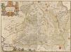
Drentia Comitatus. Transisulaniae Tabula II. [Karte], in: Novus atlas absolutissimus, Bd. 3, S. 214.
1 Karte aus Atlas Janssonius Offizin
Nova totius provinciae Groningo-Omlandiae in Belgio tabula
1 : 190000 J. Bausch sculps. Norimbergae : edentibus Homannianis Heredibus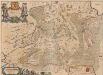
Drentia Comitatus. Transiselaniae Tabula II. [Karte], in: Novus Atlas, das ist, Weltbeschreibung, Bd. 1, S. 422.
1 Karte aus Atlas Blaeu, Joan Blaeu, Willem Janszoon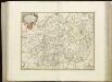
[92][93] Illustribus ac potentibus Comitatus Drentiae ..., uit: Atlas sive Descriptio terrarum orbis
Annotatie: Gedigitaliseerde versie. Amsterdam. Heiloo : Picturae (vervaardiger), 2015. tiff-bestand. Gedigitaliseerd: 07-01-2015; Origineel: Universiteitsbibliotheek Vrije Universiteit (XL.05127.-) ; Netherlands; Titelpagina ontbreekt Wit, Frederik de Amsterdam : Frederick de Wit
Dominii Groningae nec non maximae partis Drentiae novissima delineatio
1 : 180000 per Carolum Allard. 't Amsterdam : by Carel Allard
Drentia Comitatus. Transiselaniae Tabula II. [Karte], in: Theatrum orbis terrarum, sive, Atlas novus, Bd. 1, S. 458.
1 Karte aus Atlas Blaeu, Joan Blaeu, Willem Janszoon