Maps of Landkreis Emsland

1:250 000 Europe
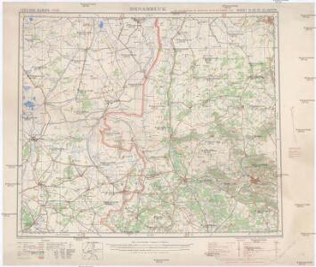
1 : 250000 Osnabrück (Německo) War Office

MONASTERIENSIS | Episcopatus
Judocus Hondius excudit.
Monasteriensis Episcopatvs
1 : 470000 Mollova mapová sbírka Schenk, Pieter Schenk, Peter I
Carta del Vescovato di Mvnster
1 : 450000 Mollova mapová sbírka Hacque, Johann Baptist
Monasteriensis Episcopatus
1 : 460000 Mollova mapová sbírka Hondius, Jodocus Hondius, Jodocus
Monasteriensis Episcopatvs
1 : 460000 Mollova mapová sbírka Gigas, Johann Michael Blaeu, Joan I.
Monasteriensis Episcopatus
1 : 460000 Mollova mapová sbírka Gigas, Johann Michael Blaeu, Willem Jansz.
Carta del vescovato di Mvnster
1 : 480000 Münster in Westfalen-oblast (Německo) Bouttats, Gerhaert Hacque, Johann Baptist
Carta del vescovato di Mvnster
1 : 480000 Münster in Westfalen-oblast (Německo) Bouttats, Gerhaert Hacque, Johann Baptist
Monasteriensis episcopatvs
1 : 485000 Münster in Westfalen-oblast (Německo) Janssonius, Johannes apud Ioannem Ianßonium
Monasteriensis episcopatus
1 : 485000 Münster in Westfalen-oblast (Německo) Gigas, Johann Michael Blaeu, Willem Janszoon apud Guiljelmum Blaeuw
Basse Partie De L'Evesché De Munster, Et Le Comté De Benthem. [Karte], in: Atlas nouveau, contenant toutes les parties du monde [...], Bd. 1, S. 307.
1 Karte aus Atlas Sanson, Nicolas Jaillot, Alexis Hubert und Mortier, Pieter
Carte Nouvelle de l'Eveché de Munster
1 : 180000 Mollova mapová sbírka Grancourt
Territorium Seculare Episcopatvs Monasterii Mvnster Germanis dicti
1 : 420000 Mollova mapová sbírka Homann, Johann Baptist Homann, Johann Baptista - dědici
Carte topographique d'Allemagne
1 : 214500 Friesland (Německo) Jaeger, Johann Wilhelm Abraham I.W.A. Iaeger
Monasteriensis et Osnabvrgensis episcopatvs descriptio
1 Karte : Kupferdruck ; 36 x 25 cm Mascop; Ortelius s.n.
Monasteriensis et Osnabvrgensis episcopatvs descriptio
1 Karte : Kupferdruck ; 25 x 36 cm Mascop; Ortelius s.n.
Transiselania Dominium vernaculè Over-Yssel. [Karte], in: Novus Atlas, das ist, Weltbeschreibung, Bd. 1, S. 417.
1 Karte aus Atlas Blaeu, Joan Blaeu, Willem Janszoon
Transiselania Dominium vernaculè Over-Yssel. [Karte], in: Le théâtre du monde, ou, Nouvel atlas contenant les chartes et descriptions de tous les païs de la terre, Bd. 1, S. 450.
1 Karte aus Atlas Blaeu, Willem Janszoon und Blaeu, Joan Blaeu, Willem Janszoon
TRANSISELANIA | DOMINIVM | vernaculè | OVER-YSSEL.
[Amsterdam : Joan Blaeu]
Transiselania Dominium vernaculè Over-Yssel. [Karte], in: Theatrum orbis terrarum, sive, Atlas novus, Bd. 1, S. 453.
1 Karte aus Atlas Blaeu, Joan Blaeu, Willem Janszoon
TRANSISELANIA | DOMINIVM | vernaculè | OVER-YSSEL.
[Amsterdam : Joan Blaeu]
La Seigneurie D'Over-Yssel subdivisée en Trois Parties Sallant, Twente, et Drente [Karte], in: Atlas nouveau, contenant toutes les parties du monde [...], Bd. 2, S. 83.
1 Karte aus Atlas Sanson, Nicolas Jaillot, Alexis Hubert und Mortier, Pieter
L'Eveché de Munster Le Comté de Bentheim Tecklenbourg Stenford Lingen, Diepholtz Delmenhorst, Ritberg &c.
1 : 420000 Mollova mapová sbírka Le Rouge, Georges-Louis Le Rouge, Georges-Louis
Basse Partie de l'Evesché de Munster, et le Comté de Benthem
1 : 300000 Mollova mapová sbírka Sanson, Guillaume Mortier, Pierre
La Seigneurie d'Over-Yssel, subdivisée en Trois Parties Sallant, Twente, et Drente
1 : 280000 Mollova mapová sbírka Sanson, Guillaume Mortier, Cornelis
La Seigneurie d'Over-Yssel, subdivisée en Trois Parties Sallant, Twente, et Drente
1 : 280000 Mollova mapová sbírka Sanson, Guillaume Jaillot, Alexis Hubert
La Seigneurie d'Over-Yssel : subdivisée en trois parties Sallant, Twente, et Drente / dressée sur les memoires les plus nouveaux par le Sr. Sanson
1 : 250000 Annotatie: Uit: Atlas nouveau, contenant toutes les parties du Monde ... Sanson, Guillaume A Paris : chez H. Iaillot