Maps of Drenthe
[Zuid-Groningen en Drente]
1 : 100000 [door H.J. Weits (?)]
La Seigneurie d'Over-Yssel, subdivisée en Trois Parties Sallant, Twente, et Drente
1 : 280000 Mollova mapová sbírka Sanson, Guillaume Mortier, Cornelis
La Seigneurie d'Over-Yssel, subdivisée en Trois Parties Sallant, Twente, et Drente
1 : 280000 Mollova mapová sbírka Sanson, Guillaume Jaillot, Alexis Hubert
La Seigneurie d'Over-Yssel : subdivisée en trois parties Sallant, Twente, et Drente / dressée sur les memoires les plus nouveaux par le Sr. Sanson
1 : 250000 Annotatie: Uit: Atlas nouveau, contenant toutes les parties du Monde ... Sanson, Guillaume A Paris : chez H. Iaillot
La Seigneurie D'Over-Yssel subdivisée en Trois Parties Sallant, Twente, et Drente [Karte], in: Atlas nouveau, contenant toutes les parties du monde [...], Bd. 2, S. 83.
1 Karte aus Atlas Sanson, Nicolas Jaillot, Alexis Hubert und Mortier, Pieter
De Heerlycheyt van Over-Yssel
1 : 380000 Nizozemsko Goos, Abraham C.I. Visscher
Drenthe, uit: Sterfte-atlas van Nederland over 1860-1874 / [uitgave van de Nederlandsche Maatschappij tot Bevordering der Geneeskunst]
titelvariant: Sterfte-atlas van Nederland; Annotatie: Alleen kaartbijlage aanwezig Pieter Harmen Witkamp 1816-1892; Nederlandsche Maatschappij tot Bevordering der Geneeskunst Amsterdam : van Rossen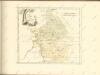

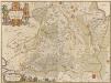
Drentia Comitatus. Transisulaniae Tabula II. [Karte], in: Novus atlas absolutissimus, Bd. 3, S. 214.
1 Karte aus Atlas Janssonius Offizin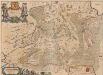
Drentia Comitatus. Transiselaniae Tabula II. [Karte], in: Novus Atlas, das ist, Weltbeschreibung, Bd. 1, S. 422.
1 Karte aus Atlas Blaeu, Joan Blaeu, Willem Janszoon
Kaart van Groningen en Drenthe
1 : 500000 volgens de nieuwste en naauwkeurigste stukken zamengesteld en in het koper gebragt door Dl. Veelwaard, Junior. Te Haarlem : bij de Erven F. Bohn
Groningen 43, uit: Special-Karte von Mittel-Europa / nach amtlichen Quellen bearbeitet von W. Liebenow
1 : 300000 titelvariant: W. Liebenow's Mittel-Europa; Annotatie: Titel boven de bladen: W. Liebenow's Mittel-Europa Johannes Wilhelm Liebenow 1822-1897 Frankfurt a. M. : Ludwig Ravenstein
Kaart van de provincie Drenthe / door A. Werneke Cz.
1 : 185000 Werneke, A. (Cz.) Te Assen : bij T.J. van Tricht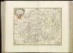
[92][93] Illustribus ac potentibus Comitatus Drentiae ..., uit: Atlas sive Descriptio terrarum orbis
Annotatie: Gedigitaliseerde versie. Amsterdam. Heiloo : Picturae (vervaardiger), 2015. tiff-bestand. Gedigitaliseerd: 07-01-2015; Origineel: Universiteitsbibliotheek Vrije Universiteit (XL.05127.-) ; Netherlands; Titelpagina ontbreekt Wit, Frederik de Amsterdam : Frederick de Wit
Groningen 43, uit: [W. Liebenow's Special-Karte von Mittel-Europa]
1 : 300000 titelvariant: W. Liebenow's Mittel-Europa; Annotatie: Titel boven de bladen: W. Liebenow's Mittel-Europa Johannes Wilhelm Liebenow 1822-1897 Hannover : Hermann Oppermann
Carte von Over-Yssel und Drenthe
1 : 230000 entworfen durch F.L. Güssefeld und hrsg. von den Homännischen Erben. Zu Nürnberg : Homännische Erben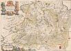
Drentia Comitatus. Transiselaniae Tabula II. [Karte], in: Theatrum orbis terrarum, sive, Atlas novus, Bd. 1, S. 458.
1 Karte aus Atlas Blaeu, Joan Blaeu, Willem Janszoon
DRENTIA | COMITATVS. | Transiselaniæ Tabula II
Auctore Cornelio Pynacker I.C. [Amsterdam : Joan Blaeu]
Illustribus Ac Potentibus Comitatus Drentiae D.D. Statoribus [...] [Karte], in: Gerardi Mercatoris et I. Hondii Newer Atlas, oder, Grosses Weltbuch, Bd. 1, S. 478.
1 Karte aus Atlas Mercator, Gerhard und Hondius, Jodocus Jansson, Jan
Drentia Comitatus. Transiselaniae Tabula II. [Karte], in: Le théâtre du monde, ou, Nouvel atlas contenant les chartes et descriptions de tous les païs de la terre, Bd. 1, S. 455.
1 Karte aus Atlas Blaeu, Willem Janszoon und Blaeu, Joan Blaeu, Willem Janszoon
Drentia Comitatus Transiselaniae Tabula II
1 : 220000 Auctore Cornelio Pynacker I.C. [Amsterdam] : [Iohannem Blaev]
Illustribus ac Potentibus comitatus Drentiae D. D. Statoribus
1 : 170000 Mollova mapová sbírka Pijnacker, Cornelis van Covens, Johannes I
Nova totius provinciae Groningo-Omlandiae in Belgio tabula
1 : 200000 Groningen (Nizozemsko) edentibus Homannianis Heredibus
Drentia comitatvs
Bouttats, Gaspar
Illustribus ac potentibus comitatus Drentiae DD. Statoribus ... Reflorescentis Provinciae et Westerwoldiae Dominii typum emendatum LMQ dedicat Cornelius Pynacker.
1 : 225000 Amstelodami : apud F. de Wit, ex officina I. Covens et C. Mortier
Drente, uit: [Provinciale fietskaart ...]
Annotatie: Boven en onder het kaartbeeld verkeersborden voor wielrijders; Provincienaam op voorkant geflankeerd door provinciewapen en wapen van de provinciehoofdstad, waaronder een stadsbeeld met fietser in klederdracht; Kaart van Overijssel ontbreekt Deventer : Burgers E.N.R
Nieuwe naaukeurige kaart van het graafschap Drente.
1 : 430000 [Te Amsterdam : by Hendrik de Leth [...]
Illustribus ac potentibus comitatus Drentiae D.D. Statoribus ... Reflorescentis Provinciae et Westerwoldiae Dominii Typum Emendatum LMQ dedicat Cornelius Pijnacker 1634.
1 : 225000 Amstelodami : Henricus Hondius excudit
![[Zuid-Groningen en Drente]](https://images-2.georeferencer.com/images/iiif/558894439117/full/,300/0/native.jpg)

