Maps of England

Charte von England
Anglie Streit, Friedrich Wilhelm
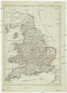
England.
1 : 1760000 Mitchell, Samuel Augustus
England.
1 : 1760000 Mitchell, Samuel Augustus
England.
1 : 1760000 Tanner, Henry S.
Composite: England & Wales.
1 : 633600 Stanford, Edward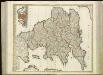
[86][86] Anglia Regnum ..., uit: Atlas sive Descriptio terrarum orbis
Annotatie: Gedigitaliseerde versie. Amsterdam. Heiloo : Picturae (vervaardiger), 2015. tiff-bestand. Gedigitaliseerd: 07-01-2015; Origineel: Universiteitsbibliotheek Vrije Universiteit (XL.05127.-) ; Netherlands; Titelpagina ontbreekt Wit, Frederik de Amsterdam : Frederick de Wit
Great Britain
A new general atlas of modern geography, consisting of a complete collection of maps of the four quarters of the globe Wyld, James James Wyld
Composite: England.
1 : 755000 Pinkerton, John, 1758-1826
Composite: England, Wales.
1 : 675000 Rocque, John
England and wales.
1 : 13000000 Colton, G.W.
England
1 Karte : Kupferdruck ; 65 x 52 cm Mannert; Schneider; Rocque; Kitchin; Campbell; Cary bey Adam Gottl. Schneider und Weigel
England.
1 : 1220000 Playfair, Principal
[Recto], uit: England and Wales
1 : 1108000 [London] : Philip [etc.]
England, Wales.
1 : 2400000 Mitchell, Samuel Augustus
Ireland, Scotland.
1 : 2400000 Mitchell, Samuel Augustus
England, Wales.
1 : 2400000 Mitchell, Samuel Augustus Jr.
England, Wales.
1 : 2400000 Mitchell, Samuel Augustus
England, Wales.
1 : 2400000 Mitchell, Samuel Augustus
Charte von England
Anglie
Charte von England
Anglie
Charte von England
Anglie
CHARTE von ENGLAND
Anglie

England.
1 : 2800000 Tanner, Henry S.
delineation of the strata of England and Wales, with part of Scotland
Übersichtskarte Smith, William Cary
England and Wales.
1 : 1500000 Colton, G.W.
Cycling road-map of England & Wales
1 : 1038000 Anglie G. W. Bacon & Co.
Regni Angliæ nova tabula
1 Karte : Kupferdruck ; 49 x 49, Gesamtgrosse 49 x 58 cm Ottens; Ottens apud R. et I. Ottens
A new and correct map of the roads in England and Wales wherein are contained all the road waies and the principal cross roads, with the computed distances [...] &c.
1 : 1300000 ingraven by Sutton Nicholls London : printed and sold by H. Overton at the White Horse without Newgate