Maps of England

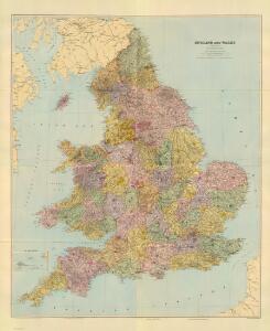
Composite: England & Wales.
1 : 633600 Stanford, Edward
England.
1 : 1760000 Mitchell, Samuel Augustus
England.
1 : 1760000 Mitchell, Samuel Augustus
England.
1 : 1760000 Tanner, Henry S.
Composite: England, Wales.
1 : 575000 Robert Laurie & James Whittle
Regni Angliæ nova tabula
1 Karte : Kupferdruck ; 49 x 49, Gesamtgrosse 49 x 58 cm Ottens; Ottens apud R. et I. Ottens
England and Wales.
1 : 2050000 Carey, Mathew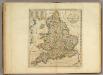
Map of England and Wales.
1 : 2000000 Carey, Mathew
England and Wales.
1 : 1900800 Carey, Mathew
Map Of England and Wales.
1 : 1900800 Carey, Mathew
Map Of England and Wales.
1 : 1900800 Carey, Mathew
Charte von England
Anglie Streit, Friedrich Wilhelm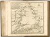

Regnum Angliæ, sive pars australis Magnæ Britanniæ
1 Karte : Kupferdruck ; 47 x 58 cm Valck; Valck Gerard und Leonardus Valck
Anglia regnvm
1 Karte : Kupferdruck ; 37 x 48 cm s.n.
Geological map of England and Wales / publ. under the superintendence of the Society for the Diffusion of Useful Knowledge ; arr. by Roderick Impey Murchison ; S.P. Woodward del.; cold. by T. Malby; J. & C. Walker sculpt
1 : 1780000 Annotatie: Oorspr. uitg.: Strand : Chapman and Hall, 1843; Annotatie geografische gegevens: Met aanvullingen tot 1847 Roderick Impey Murchison 1792-1871; S.P. Woodward; T. Malby; Society for the Diffusion of Useful Knowledge London : Knight
47-48. Inghilterra, Galles.
1 : 1500000 Touring club italiano
Britannia Antiqua.
1 : 2800000 Horsley, John, 1675-1732
England & Wales.
1 : 1013760 Stanford, Edward
England And Wales.
1 : 2850000 Finley, Anthony
England.
1 : 2800000 Tanner, Henry S.
Smith's new map of England and Wales with parts of Scotland : including the turnpike, and principal crossroads ... / engraved by Edw[ar]d Jones & Benj[ami]n Smith
1 : 1275000 Jones, Edward (fl. 1806); Smith, Benjamin London : C. Smith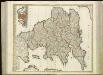
[86][86] Anglia Regnum ..., uit: Atlas sive Descriptio terrarum orbis
Annotatie: Gedigitaliseerde versie. Amsterdam. Heiloo : Picturae (vervaardiger), 2015. tiff-bestand. Gedigitaliseerd: 07-01-2015; Origineel: Universiteitsbibliotheek Vrije Universiteit (XL.05127.-) ; Netherlands; Titelpagina ontbreekt Wit, Frederik de Amsterdam : Frederick de Wit
[Recto], uit: England and Wales
1 : 1108000 [London] : Philip [etc.]
Le royaume d'Angleterre
1 Karte : Kupferdruck ; 55 x 47 cm Le Rouge; Basset; Basset chez Basset rue St. Jacques
Le royaume d'Angleterre
1 Karte : Kupferdruck ; 55 x 47 cm Le Rouge; Basset; Basset chez Basset rue St. Jacques
Britanniæ sive Angliæ regnum
1 Karte : Kupferdruck ; 56 x 48 cm Lotter Tobias Konrad Lotter
Le royaume d'Angleterre
1 Karte : Kupferdruck ; 55 x 47 cm Le Rouge Georges Louis Le Rouge rue des Augustins
Britanniæ sive Angliæ regnum
1 Karte : Kupferdruck ; 56 x 48 cm Seutter Matthäus Seutter
Anglia Cambdeni
1 Karte : Kupferdruck ; 38 x 32 cm Camden; Weigel; Kauffer Christoph Weigel
Magnæ Britanniae pars meridionalis, in qua regnum Angliæ
1 Karte : Kupferdruck ; 55 x 47 cm Homann; Visscher Johann Baptist Homann
Nouvelle carte de l'Angleterre
1 Karte : Kupferdruck ; 45 x 47 cm, Gesamtgrösse 45 x 63 cm Châtelain s.n.
Anglia in septem anglo-saxonum regna
1 Karte : Kupferdruck ; 53 x 47 cm Schenk Pieter Schenk
A new mapp of the kingdome of England
1 Karte : Kupferdruck ; 57 x 50 cm printed and given out by Nicolas Visscher upon the Dam at the signe of the fisher, by Iohn Overton at the white horse without Newgate
A new mapp of the kingdome of England
1 Karte : Kupferdruck ; 57 x 50 cm printed and given out by Nicolas Visscher upon the Dam at the signe of the fisher, by Iohn Overton at the white horse without Newgate
Anglia regnum in omnes suos ducatus, comitatus, et provincias divisum
1 Karte : Kupferdruck ; 57 x 48 cm Wit Frederick de Wit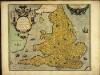
Angliæ regni florentissimi nova descriptio
1 Karte : Kupferdruck ; 38 x 45 cm Lhuyd; Ortelius s.n.