Maps of Bourgogne-Franche-Comté

Postkarte von Frankreichs innern Departements oder von Burgund und dem Mittlern-Frankreich
Burgundsko (Francie) Müller, Franz im von Reillyschen Landkarten und Kunstwerke Verschleiss Komptoir
France Canaux
Vidal de La Blache, Paul
France Canaux
Vidal de La Blache, Paul
V, uit: General-Karte von Mittel-Europa in 12 Blättern, im Masse 1:1.200.000 / entworfen, bearb. und hrsg. von Josef Schlacher
1 : 1200000 Annotatie: Blad 6 ontbreekt; Annotatie geografische gegevens: 21 maatstokken op blad 9; Legenda op blad 9 Wien : K.K. Militär Geografisches Institut
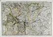
Der Nordöstliche Theil von Frankreich
Hand-Atlas über alle Theile der Erde nach dem neuesten Zustande und über das Weltgebäude Stieler, Adolf bei Justus Perthes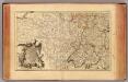
L'Alemagne 3.
1 : 1800000 Rizzi Zannoni, Giovanni Antonio Bartolomeo, 1736-1814
Östreichisch-französischer Kriegsschauplatz
1 : 710000 Evropa západní Schraembl, Franz Anton F. A. Schrämbl
Östreichisch-französischer Kriegsschauplatz
Francie in der Schrämblischen Buchhandlung
France frontiére Nord-Est et alsace-lorraine
Vidal de La Blache, Paul
Nova et Accuratißima Galliae Tabula, Vulgo Royaume De France
1 : 920000 Mollova mapová sbírka Danckerts, Justus Danckerts, Justus

France Régionale Bassin de Paris Région du Nord carte physique
Gallois, Lucien
Der Nordoestliche Theil von Frankreich
Stieler's Hand-Atlas Stieler, Adolf bei Justus Perthes

Übersichtskarte des deutsch-französischen Kriegsschauplatzes
1 : 750000 Francie k. u. k. Hof- und Universitätsbuchhandlung R. Lechner (W. Müller)
Übersichtskarte des deutsch-französischen Kriegsschauplatzes
1 : 750000 Francie k. u. k. Hof- und Universitätsbuchhandlung R. Lechner
Karten des französisch-belgischen Kriegsschaplatzes
1 : 1000000 Belgie Velhagen & Klasing
France Régionale France de l’Est Jura-Bassin de la Saône carte physique
Gallois, Lucien
[19][19] Gouvernement general du Pays Orleanois, uit: Atlas sive Descriptio terrarum orbis
Annotatie: Gedigitaliseerde versie. Amsterdam. Heiloo : Picturae (vervaardiger), 2015. tiff-bestand. Gedigitaliseerd: 07-01-2015; Origineel: Universiteitsbibliotheek Vrije Universiteit (XL.05127.-) ; Netherlands; Titelpagina ontbreekt Wit, Frederik de Amsterdam : Frederick de Wit
Karta dlja ob‘‘jasnenija pervonačal’nych dějstvij vo Francii
Frankreich Befreiungskriege <1813-1815>
L'Empire, d'Allemagne
1 : 1200000 Mollova mapová sbírka Sanson, Nicolas Quasy, Robert
France Régionale France de l’Est Jura-Bassin de la Saône carte politique
Gallois, Lucien
France II.
1 : 1750000 Society for the Diffusion of Useful Knowledge (Great Britain)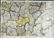
Carte de la république de France, no. 4
1 Blatt : 41 x 59 cm s.n.
France Flle. Est.
1 : 1000000 Vivien St Martin, L.
Postarum seu Veredariorum Stationes Per Germaniam et Provincias Adiacentes.
1 : 400000 Mollova mapová sbírka Danckerts, Justus Danckerts, Cornelis
Govvernement general d'Orleans
1 Karte : Kupferdruck ; 27 x 36 cm Merian Caspar Merian
Theatre de la Guerre en Allemagne et dans les Pays Bas.
1 : 1100000 Mollova mapová sbírka Nolin, Jean-Baptiste Nolin, Jean-Baptiste I.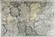
Neueste Generalkarte von Frankreich, 4
1 Blatt : 53 x 77 cm F.A. Schrämbl