Maps of Brandenburg
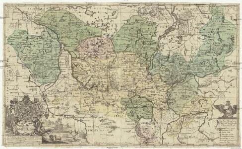
Land-Charte des Chvrfürstenthums Brandenburg
1 : 500000 Braniborsko (Německo) Gundling, Jakob Paul von Busch, Georg Paul G.P. Busch
Land-Charte des Chvrfürstenthums Brandenburg
1 : 396000 Braniborsko (Německo) Gundling, Jakob Paul von Busch, G. P. G. P. Busch
Le Marquisat et Eslectorat de Brandebourg, qui fait partie du Cercle de la Haute Saxe divisé en ses Principales Parties
1 : 490000 Mollova mapová sbírka Sanson, Guillaume Jaillot, Alexis Hubert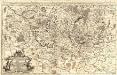
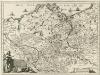
Das Marggraf- und Churfürstenthum Brandenburg
1 : 500000 Mollova mapová sbírka Sanson, Guillaume Hipschmann, Sigmund Gabriel Hoffmann, Johann
Electoratus sive Marchia Brandenburgensis, juxta novissimam Delineationem in mappa Geographica accuratae aeri incisa opera et Sumptibus
1 : 500000 Mollova mapová sbírka Seutter, Matthäus Seutter, Matthäus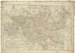
Karte von der Mark Brandenburg
1 : 514000 Braniborsko (Německo) Oesfeld, Karl Ludwig von Schneider u. Weigelschen Kunst und Buchhandlung
Electoratus sive marchia Brandenburgensis juxta novissimam delineationem in mappa geographica, accurate aeri incisa
1 : 548000 Braniborsko (Německo) Seutter, Matthäus sumptibus Mathaei Seutteri
Electoratus sive marchia Brandenburgensis juxta novissimam delineationem in mappa geographica accurate aeri incisa
1 : 548000 Braniborsko (Německo) Seutter, Matthäus Mathaei Seutteri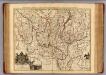
Brandenburg.
1 : 540000 Gundling, Jacob Paul, Freiherr von
Die Königl. Preussische Provinz Brandenburg
1 : 625000 Berlín (Německo) Weiland, Karl Ferdinand Verlage des geogr. Instituts

Brandenburg.
1 : 920000 Radefeld, Carl Christian Franz, 1788-1874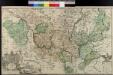
Land-Charte Des Chvrfürstenthums Brandenburg
Gundling, Jakob Paul von; Busch, Georg Paul
Cette Carte du Brandbourg
1 : 540000 Mollova mapová sbírka Le Rouge, Georges-Louis Martinet Le Rouge, Georges-Louis
Land-Charte des Chur-Fürstenthums
1 : 540000 Mollova mapová sbírka Busch, Georg Paul Covens, Johannes I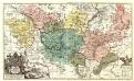
Land-Charte des Chvrfürstenthums Brandenburg
1 : 500000 Mollova mapová sbírka Gundling, Jakob Paul von Büsch, Georg Paul
Provinz Brandenburg
Grosser Hand-Atlas über alle Theile der Erde in 170 Karten Meyer, J. Verlag des Bibliographischen Instituts
Electoratus sive marchia Brandenburgensis, juxta novissimam delineationem in mappa geographica, accuratae aeri incisa
1 : 500000 opera et sumptibus Matthaei Seutteri [...] August. Vind. August. Vind. : Matthaeus Seutterus
Mappa Geographica exhibens Electoratum Brendenburgensem
1 : 540000 Mollova mapová sbírka Lotter, Tobias Conrad Scheller, F. Augustin Lotter, Tobias Conrad
Kreise der Provinz Brandenburg 1864
Preußen, Provinz Brandenburg, Verwaltungsgliederung Kunz, Andreas ; Moeschl, Joachim Robert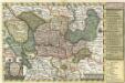
Reise Charte durch das Churfürstenthum Brandenburg
1 : 2000000 Mollova mapová sbírka Schreiber, Johann Georg Schreiber, Johann Georg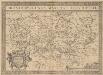
Brandeburgensis Marchae Descriptio. [Karte], in: Theatrum orbis terrarum, S. 233.
1 Karte aus Atlas Ortelius, Abraham Vrients, Jan Baptista
Carte de l'Electorat de Brandebourg presentée très humblement à Son Altesse Rojale Monsgr. le Prince Fréderic Guillaume, Prince de Prusse & Marggrave de Brandebourg
1 : 600000 Mollova mapová sbírka Güssefeld, Franz L. Dorn, Sebastian Homann, Johann Baptista - dědici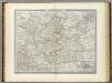
Brandenburg.
1 : 640000 Weiland, C. F. (Carl Ferdinand), d. 1847
Electoratus sive marchia Brandenburgensis
1 : 1500000 accuratae aeri incisa opera et sumptibus Matthaei Seutteri Albrecht Carl Seutter delin. et sculps. August. Vind : [M. Seutter]
Marchesato et Elettorato di Brandebvrg
1 : 780000 Mollova mapová sbírka Cantelli, Giacomo Donia, Francesco De Rossi, Giovanni Giacomo
Die Preussische Provinz Brandenburg
Brandenburgum Marchionatus, cum Ducatibus Pomeraniae et Mekelenburgi
1 : 1100000 Mollova mapová sbírka Sandrart, Jakob von Sandrart, Jacob von
Brandenbvrgvm Marchionatvs
1 : 820000 Mollova mapová sbírka Janssonius, Johannes Janssonius, Johannes I