Maps of Brandenburg
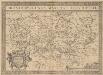
Brandeburgensis Marchae Descriptio. [Karte], in: Theatrum orbis terrarum, S. 233.
1 Karte aus Atlas Ortelius, Abraham Vrients, Jan Baptista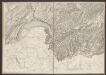
Le Marquisat et Eslectorat De Brandebourg qui fait partie du Cercle de la Haute Saxe, divisé en ses Principales Parties [Karte], in: Atlas nouveau, contenant toutes les parties du monde [...], Bd. 1, S. 327.
1 Karte aus Atlas Sanson, Nicolas Jaillot, Alexis Hubert und Mortier, Pieter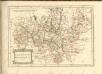
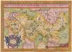
Brandeburgensis Marchae Descriptio. [Karte], in: Theatrum orbis terrarum, S. 141.
1 Karte aus Atlas Ortelius, Abraham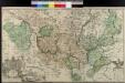
Land-Charte Des Chvrfürstenthums Brandenburg
Gundling, Jakob Paul von; Busch, Georg Paul
Provinz Brandenburg
Marca Brandenburgensis & Pomerania. [Karte], in: Gerardi Mercatoris Atlas, sive, Cosmographicae meditationes de fabrica mundi et fabricati figura, S. 394.
1 Karte aus Atlas Mercator, Gerhard Montanus, Petrus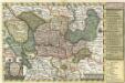
Reise Charte durch das Churfürstenthum Brandenburg
1 : 2000000 Mollova mapová sbírka Schreiber, Johann Georg Schreiber, Johann Georg
Tabula Marchionatus Brandenburgici et Ducatus Pomeraniae quae sunt Pars Septentrionalis Circuli Saxoniae Superioris novissime edita
1 : 1000000 Mollova mapová sbírka Homann, Johann Baptist Homann, Johann Baptista
Mappa Geographica exhibens Electoratum Brendenburgensem
1 : 540000 Mollova mapová sbírka Lotter, Tobias Conrad Scheller, F. Augustin Lotter, Tobias Conrad

Brandeburgum Marchionatus, cum Ducatibus Pomeraniae et Mekelenburgi. [Karte], in: Novus Atlas, das ist, Weltbeschreibung, Bd. 1, S. 99.
1 Karte aus Atlas Blaeu, Joan Blaeu, Willem Janszoon
Brandeburgum Marchionatus, cum Ducatibus Pomeraniae et Mekelenburgi. [Karte], in: Le théâtre du monde, ou, Nouvel atlas contenant les chartes et descriptions de tous les païs de la terre, Bd. 1, S. 128.
1 Karte aus Atlas Blaeu, Willem Janszoon und Blaeu, Joan Blaeu, Willem Janszoon
Die Preussische Provinz Brandenburg

Brandenburg und Pommern
Allgemeiner Atlas [Walch, Johannes] im Verlag bei Johannes Walch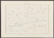
Brandeburgum Marchionatus, cum Ducatibus Pomeraniae et Mekelenburgi. [Karte], in: Theatrum orbis terrarum, sive, Atlas novus, Bd. 1, S. 161.
1 Karte aus Atlas Blaeu, Joan Blaeu, Willem Janszoon

Marchionatus Brandenburgicus [Karte], in: Novus atlas absolutissimus, Bd. 2, S. 51.
1 Karte aus Atlas Janssonius Offizin
Cette Carte du Brandbourg
1 : 540000 Mollova mapová sbírka Le Rouge, Georges-Louis Martinet Le Rouge, Georges-Louis
Land-Charte des Chur-Fürstenthums
1 : 540000 Mollova mapová sbírka Busch, Georg Paul Covens, Johannes I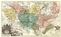
Land-Charte des Chvrfürstenthums Brandenburg
1 : 500000 Mollova mapová sbírka Gundling, Jakob Paul von Büsch, Georg Paul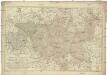
Karte von der Mark Brandenburg
1 : 514000 Braniborsko (Německo) Oesfeld, Karl Ludwig von Schneider u. Weigelschen Kunst und Buchhandlung
Electoratus sive marchia Brandenburgensis, juxta novissimam delineationem in mappa geographica, accuratae aeri incisa
1 : 500000 opera et sumptibus Matthaei Seutteri [...] August. Vind. August. Vind. : Matthaeus Seutterus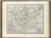
Brandenburg.
1 : 640000 Weiland, C. F. (Carl Ferdinand), d. 1847
Electoratus Brandenburgi, Mekelenburgi, Et maximae Partis Pomeraniae novissima Tabula. [Karte], in: Novus atlas absolutissimus, Bd. 2, S. 54.
1 Karte aus Atlas Janssonius Offizin
Die Königl. Preussische Provinz Brandenburg
1 : 625000 Berlín (Německo) Weiland, Karl Ferdinand Verlage des geogr. Instituts
Marchionatus | BRANDENBVRGICVS
Auth. Olao Iohannis Gotho, Gustaui Mag. R.S. Cosm. [Amsterdam : Joan Blaeu]
Carte de l'Electorat de Brandebourg presentée très humblement à Son Altesse Rojale Monsgr. le Prince Fréderic Guillaume, Prince de Prusse & Marggrave de Brandebourg
1 : 600000 Mollova mapová sbírka Güssefeld, Franz L. Dorn, Sebastian Homann, Johann Baptista - dědici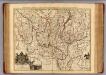
Brandenburg.
1 : 540000 Gundling, Jacob Paul, Freiherr von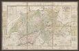
![Brandeburgensis Marchae Descriptio. [Karte], in: Theatrum orbis terrarum, S. 233.](https://images-2.georeferencer.com/images/iiif/620727672826/full/,300/0/native.jpg)

