Maps of Brandenburg
Brandenburg.
1 : 640000 Weiland, C. F. (Carl Ferdinand), d. 1847
Die Preussische Provinz Brandenburg
Reise Charte durch das Churfürstenthum Brandenburg
1 : 2000000 Mollova mapová sbírka Schreiber, Johann Georg Schreiber, Johann Georg

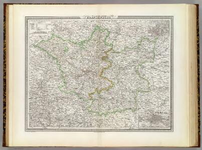
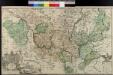
Die Königl. Preussische Provinz Brandenburg
1 : 625000 Berlín (Německo) Weiland, Karl Ferdinand Verlage des geogr. Instituts
Le Marquisat et Eslectorat De Brandebourg qui fait partie du Cercle de la Haute Saxe, divisé en ses Principales Parties [Karte], in: Atlas nouveau, contenant toutes les parties du monde [...], Bd. 1, S. 327.
1 Karte aus Atlas Sanson, Nicolas Jaillot, Alexis Hubert und Mortier, Pieter
Provinz Brandenburg
Grosser Hand-Atlas über alle Theile der Erde in 170 Karten Meyer, J. Verlag des Bibliographischen Instituts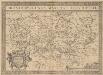
Brandeburgensis Marchae Descriptio. [Karte], in: Theatrum orbis terrarum, S. 233.
1 Karte aus Atlas Ortelius, Abraham Vrients, Jan Baptista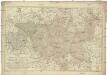
Karte von der Mark Brandenburg
1 : 514000 Braniborsko (Německo) Oesfeld, Karl Ludwig von Schneider u. Weigelschen Kunst und Buchhandlung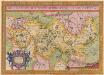
Brandeburgensis Marchae Descriptio. [Karte], in: Theatrum orbis terrarum, S. 141.
1 Karte aus Atlas Ortelius, Abraham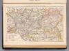
Brandenburg, Posen.
1 : 1350000 Andree, Richard
Provinz Brandenburg
Land-Charte Des Chvrfürstenthums Brandenburg
Gundling, Jakob Paul von; Busch, Georg Paul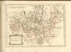

Kreise der Provinz Brandenburg 1864
Preußen, Provinz Brandenburg, Verwaltungsgliederung Kunz, Andreas ; Moeschl, Joachim Robert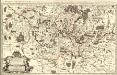
Le Marquisat et Eslectorat de Brandebourg, qui fait partie du Cercle de la Haute Saxe divisé en ses Principales Parties
1 : 490000 Mollova mapová sbírka Sanson, Guillaume Jaillot, Alexis Hubert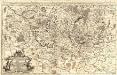
Das Marggraf- und Churfürstenthum Brandenburg
1 : 500000 Mollova mapová sbírka Sanson, Guillaume Hipschmann, Sigmund Gabriel Hoffmann, Johann
Mappa Geographica exhibens Electoratum Brendenburgensem
1 : 540000 Mollova mapová sbírka Lotter, Tobias Conrad Scheller, F. Augustin Lotter, Tobias Conrad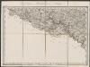
Marca Brandenburgensis & Pomerania. [Karte], in: Gerardi Mercatoris Atlas, sive, Cosmographicae meditationes de fabrica mundi et fabricati figura, S. 394.
1 Karte aus Atlas Mercator, Gerhard Montanus, Petrus
Brandenburg.
1 : 1900000 Flemming, Carl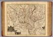
Brandenburg.
1 : 540000 Gundling, Jacob Paul, Freiherr von
Electoratus sive marchia Brandenburgensis
1 : 1500000 accuratae aeri incisa opera et sumptibus Matthaei Seutteri Albrecht Carl Seutter delin. et sculps. August. Vind : [M. Seutter]
Cette Carte du Brandbourg
1 : 540000 Mollova mapová sbírka Le Rouge, Georges-Louis Martinet Le Rouge, Georges-Louis
Land-Charte des Chur-Fürstenthums
1 : 540000 Mollova mapová sbírka Busch, Georg Paul Covens, Johannes I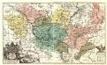
Land-Charte des Chvrfürstenthums Brandenburg
1 : 500000 Mollova mapová sbírka Gundling, Jakob Paul von Büsch, Georg Paul
Electoratus sive marchia Brandenburgensis, juxta novissimam delineationem in mappa geographica, accuratae aeri incisa
1 : 500000 opera et sumptibus Matthaei Seutteri [...] August. Vind. August. Vind. : Matthaeus Seutterus
Brandenburg.
1 : 920000 Radefeld, Carl Christian Franz, 1788-1874
Preussische Provinz Brandenburg
1 : 540000 Berlín-oblast (Německo) Gräf, Adolf Biedermann, E. Geographisches Institut