Maps of Olbernhau

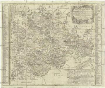
Accurate geographische Delineation derer zu den Erzgebürgischen Kreisse des Chur Fürstenthums Sachsen gehoerigen Aemmtern I. Kreiss Ammt Freyberg II. Frauenstein III. Altenberg und IV. Lauterstein auch andern angrenzenden Aemmtern und Gegenden
1 : 119000 Altenberg (Sasko, Německo) Schenk, Pieter Lotter, Tobias Conrad P. Schenk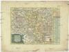
Die Aemter Freyberg und Frauenstein zu dem Ertzgebürgischen Creisse gehörig
1 : 290000 Frauenstein (Německo) Schreiber, Johann Georg bey Joh. George Schreibers See. Wittbe
Podrobná mapa Království českého
1 : 100000 Hora Svaté Kateřiny (Česko : oblast) Srp, Jan Jaroslav Bursík
Harrachs[dorf]
1 : 75000 Harrachov (Semily, Česko : oblast) Meschede, Richard K. u. k. Militärgeographisches Institut
Harrachsdorf
1 : 75000 Harrachov (Semily, Česko : oblast) K. u. k. Militärgeographisches Institut
Generalkarte der Bezirkshauptmannschaft Brüx
1 : 220000 Most-oblast (Česko) Wagner, Jan Eduard F. Kytka
Uebersicht der Stellungen der Preussischen Armee in Sachsen unter dem Prinzen Heinrich im Feldzuge 1762
1 : 100000
Mapy plánování ČSR

Brux, Dux und Teplitz.
from Spezialkarte der osterreichisch-ungarischen Monarchie.
Teplice
1 : 75000 Teplice (Česko : oblast) Vojenský zeměpisný ústav
Teplice
1 : 75000 Teplice-oblast (Česko) Vojenský zeměpisný ústav
III. vojenské mapování 3751
1 : 75000
Soubor přehledných map pro plánování a statistiku: 3751 – Teplice

Brüx, Dux und Teplitz
1 : 75000 Duchcov (Česko : oblast) Hübner K. u. k. militär-geographisches Institut
Brüx, Dux und Teplitz
1 : 75000 Duchcov (Česko : oblast) Hübner K. u. k. Militärgeographisches Institut
Brüx, Dux und Teplitz
1 : 75000 Duchcov (Česko : oblast) K. u. k. Militärgeographisches Institut
Karte des Bezirkes Dux
1 : 36000 Duchcov-oblast (Česko) Hollmann, Victor Josef Mecséry de Tsóor, Karl Johann Friedrich Selner
III. vojenské mapování 3751/2
1 : 25000
[Kartenblatt]
1 : 25000 Krušné hory (Česko a Německo) Reichsamt für Landesaufnahme

III. vojenské mapování 3751/2
1 : 25000
III. vojenské mapování 3751/2
1 : 25000
[Kartenblatt]
1 : 25000 Dubí (Teplice, Česko : oblast) Reichsamt für Landesaufnahme
III. vojenské mapování 3751/2
1 : 25000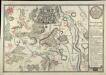
Plan Der Bataille Welche D. 29. Oct. 1762 Von Der Combinirten Ostereichischen und Reichs-Armee und der Königl. Preussischen Armee bey Freyberg geliefert worden

Section Freiberg / geologische Aufnahme von A. Sauer ; die Erzgänge von H. Müller
1 : 25000 Annotatie: Opgeborgen in magazijn bij kaarten op karton; Annotatie geografische gegevens: Met 6 profielen op schaal 1:25.000 (lengte) en 1:10.000 (hoogte) A. Sauer; Hermann Müller [Leipzig : Königliche Finanz-Ministerium]
III. vojenské mapování 3751/1
1 : 25000
Politischer Bezirk Brüx