Maps of okres Most

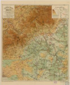
Politischer Bezirk Brüx
Karte der Bezirke Brüx & Teplitz
1 : 100000 Most-oblast (Česko) Stelzig, Heinrich Heinrich Stelzig
Brüx, Dux und Teplitz
1 : 75000 Duchcov (Česko : oblast) Hübner K. u. k. militär-geographisches Institut
Brüx, Dux und Teplitz
1 : 75000 Duchcov (Česko : oblast) Hübner K. u. k. Militärgeographisches Institut
Brüx, Dux und Teplitz
1 : 75000 Duchcov (Česko : oblast) K. u. k. Militärgeographisches Institut
Most a okolí
1 : 75000 Most (Česko : oblast) Vojenský zeměpisný ústav
Mapy plánování ČSR

III. vojenské mapování 3751
1 : 75000
Soubor přehledných map pro plánování a statistiku: 3751 – Teplice
Teplice
1 : 75000 Teplice (Česko : oblast) Vojenský zeměpisný ústav
Teplice
1 : 75000 Teplice-oblast (Česko) Vojenský zeměpisný ústav
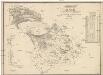
Geologische Uebersichtskarte von Teplitz, Bilin, Dux, Brüx un Umgegend
1 : 100000 Teplice-oblast (Česko) Marischler, Norbert Wolf, H. Adolf Becker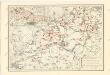
Československo v mapách
Karte des Bezirkes Dux
1 : 36000 Duchcov-oblast (Česko) Hollmann, Victor Josef Mecséry de Tsóor, Karl Johann Friedrich Selner
Chomutov a okolí
1 : 75000 Chomutov (Česko : oblast) Vojenský zeměpisný ústav
Atlas d'industrie de la république tchécoslovaque

Karte der Bezirke Teplitz und Dux
1 : 75000 Duchcov-oblast (Česko) Stelzig, Heinrich Heinrich Stelzig
Karte der Umgebungen von Brüx, Dux und Oberleutensdorf
1 : 25000 Duchcov-oblast (Česko) Schulz, Josef

III. vojenské mapování 3751/3
1 : 25000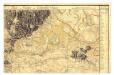

[Kartenblatt]
1 : 25000 Horní Jiřetín-oblast (Česko) Reichsamt für Landesaufnahme
[Kartenblatt]
1 : 25000 Horní Jiřetín-oblast (Česko) Reichsamt für Landesaufnahme
[Brüx und Umgebung]
Most-oblast (Česko) Kreibich, František Jakub Jindřich
Geologická mapa okolí Mostu
1 : 25000 Most (Česko : oblast) Hibsch, Josef Emanuel Purkyně, Cyrill Státní geologický ústav Československé republiky
III. vojenské mapování 3751/1
1 : 25000
III. vojenské mapování 3751/1
1 : 25000
III. vojenské mapování 3751/1
1 : 25000
[Kartenblatt]
1 : 25000 Bílina (Česko : oblast) Reichsamt für Landesaufnahme