Maps of Osek
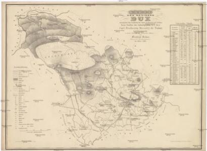
Karte des Bezirkes Dux
1 : 36000 Duchcov-oblast (Česko) Hollmann, Victor Josef Mecséry de Tsóor, Karl Johann Friedrich Selner
III. vojenské mapování 3751/2
1 : 25000
III. vojenské mapování 3751/2
1 : 25000
Meßtischblatt 131 : Neuwernsdorf, 1938
1 : 250000 Neuwernsdorf. - Umdr.-Ausg., aufgen. 1910, hrsg. 1911, bericht. 1923. - 1:25000. - Leipzig, 1938. - 1 Kt.
Meßtischblatt 131 : Neuwernsdorf, 1920
1 : 250000 Neuwernsdorf. - Aufgen. 1910. - 1:25000. - Leipzig, 1920. - 1 Kt.
Meßtischblatt 131 : Neuwernsdorf, 1919
1 : 250000 Neuwernsdorf. - Aufgen. 1910. - 1:25000. - Leipzig, 1919. - 1 Kt.
III. vojenské mapování 3751/2
1 : 25000
III. vojenské mapování 3751/2
1 : 25000
[Kartenblatt]
1 : 25000 Dubí (Teplice, Česko : oblast) Reichsamt für Landesaufnahme
Geologische und Gruben-Revier-Karte des Kohlenbeckens von Teplitz-Dux-Brüx
1 : 10000 Blatt 10 Wolf, Heinrich Lithografie u. Schnell-Pressen-Druck des k.k. Militär-geografischen Institutes
Fleyh - c1668-1-008 - Kaiserpflichtexemplar der Landkarten des stabilen Katasters
1 : 2880
Fleyh - c1668-1-003 - Kaiserpflichtexemplar der Landkarten des stabilen Katasters
1 : 2880
Fleyh - c1668-1-007 - Kaiserpflichtexemplar der Landkarten des stabilen Katasters
1 : 2880
Fleyh - c1668-1-004 - Kaiserpflichtexemplar der Landkarten des stabilen Katasters
1 : 2880
Fleyh - c1668-1-006 - Kaiserpflichtexemplar der Landkarten des stabilen Katasters
1 : 2880
Fleyh - c1668-1-011 - Kaiserpflichtexemplar der Landkarten des stabilen Katasters
1 : 2880
Fleyh - c1668-1-009 - Kaiserpflichtexemplar der Landkarten des stabilen Katasters
1 : 2880
Fleyh - c1668-1-002 - Kaiserpflichtexemplar der Landkarten des stabilen Katasters
1 : 2880
Fleyh - c1668-1-010 - Kaiserpflichtexemplar der Landkarten des stabilen Katasters
1 : 2880
Fleyh - c1668-1-001 - Kaiserpflichtexemplar der Landkarten des stabilen Katasters
1 : 2880
Fleyh - c1668-1-005 - Kaiserpflichtexemplar der Landkarten des stabilen Katasters
1 : 2880
Schönbach - c4561-2-007 - Kaiserpflichtexemplar der Landkarten des stabilen Katasters
1 : 2880
Schönbach - c4561-2-009 - Kaiserpflichtexemplar der Landkarten des stabilen Katasters
1 : 2880
Schönbach - c4561-2-004 - Kaiserpflichtexemplar der Landkarten des stabilen Katasters
1 : 2880
Schönbach - c4561-2-006 - Kaiserpflichtexemplar der Landkarten des stabilen Katasters
1 : 2880
Schönbach - c4561-2-001 - Kaiserpflichtexemplar der Landkarten des stabilen Katasters
1 : 2880
Schönbach - c4561-2-008 - Kaiserpflichtexemplar der Landkarten des stabilen Katasters
1 : 2880
Schönbach - c4561-2-003 - Kaiserpflichtexemplar der Landkarten des stabilen Katasters
1 : 2880
Schönbach - c4561-2-002 - Kaiserpflichtexemplar der Landkarten des stabilen Katasters
1 : 2880