Maps of Alföld

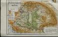
Magyarország közigazgatási törvénykezési és közlekedési térképe
1 : 3450000 Maďarsko Homolka, Josef Posner Károly Lajos és fia
Magyarország földtani térképe
1 : 3450000 Maďarsko Homolka, Josef Posner Károly Lajos és fia
Magyarország hömérsékleti és esözési térképei
Maďarsko Homolka, Josef Posner Károly Lajos és fia
Magyarország megyei térképe
1 : 5430000 Evropa jižní Homolka, Josef M. Kir. Államnyomdából
Magyarország a török hódoltság idejében
1 : 4350000 Maďarsko Homolka, Josef Ferencz, Salomon Eggenberger féle könyvkeresk. (Hofmann és Molnár)
Magyarország egyházi beosztása 1891
1 : 4450000 Maďarsko Homolka, Josef Eggenberger féle könyvkeresk. (Hofmann és Molnár)
Magyarország néprajzi térképe
1 : 4450000 Maďarsko Homolka, Josef Eggenberger féle könyvkeresk. (Hofmann és Molnár)
Magyarország hadügyi beosztása 1891
1 : 4450000 Maďarsko Homolka, Josef Eggenberger féle könyvkeresk. (Hofmann és Molnár)
Magyarország népességénék müveltségi foka 1890
1 : 5000000 Maďarsko Homolka, Josef Posner Károly Lajos és fia
Magyarország megyei beosztása 1848
1 : 4000000 Maďarsko Homolka, Josef Elek, Fényes Eggenberger féle könyvkeresk. (Hofmann és Molnár)
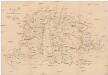
Magyarország hegyei és vizei
1 : 5320000 Budapešť (Maďarsko : oblast) Homolka, Josef M. Kir. Államnyomdából
Magyarország és a' Hozzá kapcsolt tartományok Földabrosza
1 : 970000 Chorvatsko Raffelsperger, Franz Raffelsperger F.
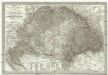
Charte des Koenigreichs Ungarn mit Einschluss der Koenigreiche Croatien u. Slavonien
1 : 2250000 Chorvatsko Bendowsky, Thomas Liechtenstern, Joseph Marx von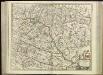
[80][80] Regnum Hungaria ..., uit: Atlas sive Descriptio terrarum orbis
Annotatie: Gedigitaliseerde versie. Amsterdam. Heiloo : Picturae (vervaardiger), 2015. tiff-bestand. Gedigitaliseerd: 07-01-2015; Origineel: Universiteitsbibliotheek Vrije Universiteit (XL.05127.-) ; Netherlands; Titelpagina ontbreekt Wit, Frederik de Amsterdam : Frederick de Wit
Karte der Königreiche Ungarn, Croatien, Slavonien und Militärgrenzen
Karte des ungarischen Communikations-Netzes
1 : 1140000 Evropa jihovýchodní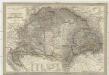
Magyar-ország
1 : 1400000 Chorvatsko Fried, Franz List, Joseph bei Artaria &. Comp.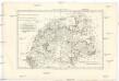
Royaume de Hongrie et pays adjacents
1 : 3420000 Maďarsko Bonne, Rigobert André
Hungaria in Partes II et Comitatus LII divisa
1 : 4300000 Mollova mapová sbírka Tomka Szászky, János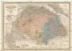
Die kaiserlich Oesterreichischen Ungarischen Erbstaaten
1 : 522000 Budapešť-oblast (Maďarsko) Weiland, Karl Ferdinand im Verlage des Geographischen Instituts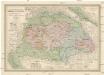
Die kaiserlich Oesterreichischen Ungarischen Erbstaaten
Maďarsko Weiland, Karl Ferdinand Prixner, Godofr. im Verlage des Geographischen Instituts
Die kaiserlich Oesterreichischen Ungarischen Erbstaaten
Maďarsko Weiland, Karl Ferdinand Prixner, Godofr. im Verlage des Geographischen Instituts
Die kaiserlich Oesterreichischen Ungarischen Erbstaaten
Maďarsko Weiland, Karl Ferdinand Prixner, Godofr. im Verlage des Geographischen Instituts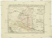
Postkarte von Nieder Ungarn, Kroatien und Sklavonien
Chorvatsko Kühn, Ignaz im von Reillyschen Landkarten und Kunstwerke Verschleiss Komptoir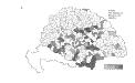
Die Bezirke der Tendenz "C" vor 1875
Ungarn Wahlbezirk, Wahlverhalten
Hungaria Regnum
General - Post- und Strassen- Karte des Königreichs Ungarn und des Grossfürstenthums Siebenbürgen
1 : 1400000 Maďarsko Fried, Franz List, Joseph Artaria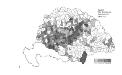
Die Bezirke der Tendenz "C" nach 1875
Ungarn Wahlbezirk, Wahlverhalten
Magyarország és Bosznia automobillal jarható útainak átnézeti térképe
1 : 900000 Bosna Benkö Gyula