Maps of Hungary

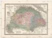
Magyarország megyei beosztása 1848
1 : 4000000 Maďarsko Homolka, Josef Elek, Fényes Eggenberger féle könyvkeresk. (Hofmann és Molnár)
Magyarország megyei térképe
1 : 5430000 Evropa jižní Homolka, Josef M. Kir. Államnyomdából
Magyarország a török hódoltság idejében
1 : 4350000 Maďarsko Homolka, Josef Ferencz, Salomon Eggenberger féle könyvkeresk. (Hofmann és Molnár)
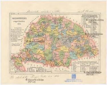
Magyarország közigazgatási törvénykezési és közlekedési térképe
1 : 3450000 Maďarsko Homolka, Josef Posner Károly Lajos és fia
Magyarország földtani térképe
1 : 3450000 Maďarsko Homolka, Josef Posner Károly Lajos és fia
Magyarország hömérsékleti és esözési térképei
Maďarsko Homolka, Josef Posner Károly Lajos és fia
Magyarország egyházi beosztása 1891
1 : 4450000 Maďarsko Homolka, Josef Eggenberger féle könyvkeresk. (Hofmann és Molnár)
Magyarország néprajzi térképe
1 : 4450000 Maďarsko Homolka, Josef Eggenberger féle könyvkeresk. (Hofmann és Molnár)
Magyarország hadügyi beosztása 1891
1 : 4450000 Maďarsko Homolka, Josef Eggenberger féle könyvkeresk. (Hofmann és Molnár)
Magyarország hegyei és vizei
1 : 5320000 Budapešť (Maďarsko : oblast) Homolka, Josef M. Kir. Államnyomdából
Magyarország népességénék müveltségi foka 1890
1 : 5000000 Maďarsko Homolka, Josef Posner Károly Lajos és fia
Magyarország és a' Hozzá kapcsolt tartományok Földabrosza
1 : 970000 Chorvatsko Raffelsperger, Franz Raffelsperger F.
Neüwe und gründtliche beschreibunge des ganczen Künigreichs Unngern mit den an[...]
Maďarsko
General - Post- und Strassen- Karte des Königreichs Ungarn und des Grossfürstenthums Siebenbürgen
1 : 1400000 Maďarsko Fried, Franz List, Joseph Artaria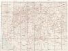
Magyarország és Bosznia automobillal jarható útainak átnézeti térképe
1 : 900000 Bosna Benkö Gyula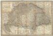
Magyar-Ország
1 : 1400000 Evropa jihovýchodní Fried, Franz List, Joseph Artaria &. Comp.
Magyar-Ország
Maďarsko Fried, Franz List, Joseph Artaria &. Comp.
Mappa Mineralographica Fodinas in Hungariâ. Partibusque adhaerentibus Ferè Omnes quae Danubium cominus aut eminus circumstant, et è quibus in eundem substantiae Minerales defluunt, suis distinctas characteribus, ostendens
1 : 1500000 Mollova mapová sbírka Marsili, Luigi Ferdinando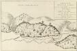
Fodinae Schmelnitzenses
Mollova mapová sbírka Marsili, Luigi Ferdinando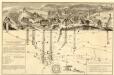
Mappa Metallographica Celebris Fodinae Semnitziensis In Hungariâ Superiori : A Quâ Effoditur Argentum Auro Mixtum, Quae Habenda Est Pro Sectione Montis, In Cuius Visceribus Inspiciuntur Subsequentia
Mollova mapová sbírka Marsili, Luigi Ferdinando
Das Königr. Ungarn mit seinen Nebenländern
Maďarsko Benecke Bormann, E. Ignaz Fuchs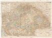
A Magyar korona országanaik közigazgatási térképe
1 : 900000 Evropa jihovýchodní Kogutowicz, Manó Magyar Földrajzi Intézet
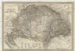
Karte von dem Königreiche Ungarn mit den Königreichen Kroatien und Sklavonien und dem Grossfürstenthum Siebenbürgen
1 : 1390000 Chorvatsko Reilly, Franz Johann Josef von Amon, Anton Franz Joh. Jos. von Reilly
Hungaria Regnum
Magyar-ország
1 : 1400000 Chorvatsko Fried, Franz List, Joseph bei Artaria &. Comp.
Théatre de la guerre actuelle, en Allemagne, en Pologne et en Turquie. n18, Bellegrade, Sziget ou Ziget
1 : 900000 Chanlaire, Pierre Grégoire 1758-1817 Paris : chez l'auteur P. G. Chanlaire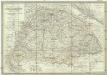
Die kaiserlich oesterreichischen ungarischen Erbstaaten, das ist Ungarn, Siebenbürgen, Dalmatien und die Militair-Graenze
1 : 1522000 Dalmácie (Chorvatsko) Weiland, Karl Ferdinand im Verlage des Geographischen Instituts
Kaiserlich Oesterreichischen Ungarischen Erbstaaten
1 : 1500000 Dalmácie (Chorvatsko) Weiland, Karl Ferdinand Geographischen Instituts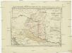
Postkarte von Nieder Ungarn, Kroatien und Sklavonien
Chorvatsko Kühn, Ignaz im von Reillyschen Landkarten und Kunstwerke Verschleiss Komptoir
Die kaiserlich oesterreichischen ungarischen Erbstaaten
1 : 1522000 Dalmácie (Chorvatsko) Weiland, Karl Ferdinand im Verlage des Geographischen Instituts
Die kaiserlich oesterreichischen ungarischen Erbstaaten
1 : 1522000 Dalmácie (Chorvatsko) Weiland, Karl Ferdinand im Verlage des Geographischen Instituts