Maps of Minsk Region

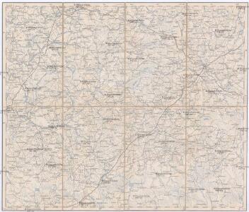
Wilna, Minsk, Grodno, Słonim
1 : 750000 Grodno (Bělorusko : oblast) Jakupec, M. K. u. k. Militärgeographisches Institut
Wilna, Minsk, Grodno, Słonim
1 : 750000 Grodno (Bělorusko : oblast) K. k. militär-geographisches Institut
Übersichtskarte von Mittel - Europa

Übersichtskarte von Mittel - Europa

Raspoloženīe vojska 1. ījulja.
Litauen Weißrussland Russlandfeldzug <1812>
Wiłkomierz, Dwinsk (Dünaburg), Wilna, Wilejka, Słonim, Mińsk
1 : 300000 Minsk (Bělorusko : oblast)
Zdzienciol, Gorodischtsche, Derewna, Ljachowitschi
1 : 100000 Bělorusko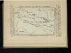
Karta di’jstvij ot‘‘ Bereziny k‘‘ Vil’ně
Litauen Vilnius Russlandfeldzug <1812>
Raspoloženīe 1 i 2 armīi pered vojnoju.
Litauen Weißrussland Napoleonische Kriege
Trigonometrisk grunnlag, vedlegg 65, 6-9: Grunnlagspunkter for Struves meridianbue fra Vilnius, Hrodna og Kurland
1 : 200000 de Tenner
Nowogródek

Grodno-Ost, Ostryna, Bielica, Indura, Mosty, Wenzowiec, Swislocz, Wolkowyßk, Slonim
1 : 100000 Bělorusko
Iwje, Ljubtscha, Nowogródek, Korelitschi, Zdzienciol, Gorodischtsche
1 : 100000 Dzjatlava (Bělorusko)
Plan mi''stopoloženija meždu Borisovym i Zembinom
Russland Borisov Russlandfeldzug <1812>
Die Beresina
1 : 500000 Beresina-Gebiet Schlacht an der Beresina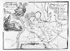
Vilnius. XVIII. šimtmečio pabaigoje
Vilnius Altstadt
Delineatio memorabilis conflictus et victoriae Lithuanorum Duce Radivilio de Cricevio
Bělorusko
Castra defensiva Ducis Radiuly Reciciae, obiecta aduentui Eliae Bohaczenlio
Bělorusko
Mapa nowej unji Polski z Litwą
1 : 2000000 Bělorusko Romer, Eugeniusz Instytut kartograficzny Atlas
Li palatinati di Nowogrodek Podlachia e Brzesk Littew / tratta dall'atlante polacco del Sig.r Rizzi
1 : 1300000 1 Karte : Kupferdruck ; 31 x 40 cm Zuliani, Giuliano presso Antonio Zatta
Litauen, O. Pruisen en Noord Gouv. Gen.
1 : 3000000 Annotatie: Vrijgegeven door W.B.N. 15-5-'44 Den Haag : Kompas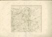

[Litauen, Lettland]
Litauen, Lettland, ethnische Gruppe
Geologičeskaja karta Polěs'ja
1 : 1250000 Polesí
Kartenskizze des polnisch-weißrussischen Grenzgebietes
Polen Weißrussland Grenzgebiet
Gipsometričeskaja karta Polěs'ja s oboznačenijem kanalizacii
1 : 1250000 Polesí
Li palatinati di Minsk, Mscislaw, Polok, e Witebsk nella Littuania / tratta dall'atlante polacco del
1 : 1400000 1 Karte : Kupferdruck ; 40 x 30 cm Zuliani, Giuliano presso Antonio Zatta
Kijew, Žitomir, Owrucz, Czernobyl, Mozyr, Łojew
1 : 750000 Kyjev (Ukrajina : oblast) Korb, L. K. u. k. Militärgeographisches Institut
Bobrujsk, Czerikow, Str. Szkłow
1 : 750000 Bobrujsk (Bělorusko) Dornhofer, J. K. u. k. Militärgeographisches Institut
Bobrujsk, Czerikow, Str. Szkłow
1 : 750000 Bobrujsk (Bělorusko) K. k. militär-geographisches Institut